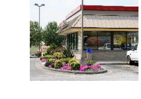
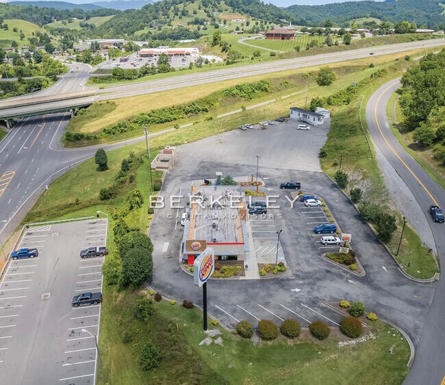
Property Record
71 Regional Park Rd, Lebanon, VA 24266
NEARBY LISTINGS FOR SALE OR LEASE
Property Detail
71 Regional Park Rd
Other Market Areas
Gray Heights
104R971C1
Russell
Restaurantbuilding
Virginia
X
1.17 AC
51167C0245C
Virginia Regional
3,468 SF
DEMOGRAPHICS near 71 Regional Park Rd
1 Mile
3 Mile
5 Mile
2024 Total Population
1,062
4,915
6,926
2029 Population
1,038
4,825
6,825
Pop Growth 2024-2029
(2.26%)
(1.83%)
(1.46%)
Average Age
44
44
44
2024 Total Households
474
2,139
3,005
HH Growth 2024-2029
(2.32%)
(1.78%)
(1.40%)
Median Household Inc
$40,952
$40,718
$42,053
Avg Household Size
2.10
2.20
2.20
2024 Avg HH Vehicles
2.00
2.00
2.00
Median Home Value
$155,508
$143,942
$134,025
Median Year Built
1980
1983
1982
Nearby Places
Map Layers
Map Styles
 Street
 Aerial
- Restaurants
- Banks
- Shops
- Fitness
- Groceries
SALE & LEASE HISTORY
LISTING DATE
SALE/LEASE

Sep 24, 2016
For Sale
Sep 24, 2016
For Sale
Oct 17, 2022
For Sale
Jan 02, 2018
For Sale
Nearby Properties
Address
Land Use
TOTAL SIZE
Lot Size
Zoning
Address
Land Use
TOTAL SIZE
Lot Size
Zoning
100,275 SF
13.30 AC
Address
Land Use
TOTAL SIZE
Lot Size
Zoning
154,827 SF
16.26 AC
Address
Land Use
TOTAL SIZE
Lot Size
Zoning
41,924 SF
10.35 AC
Address
Land Use
TOTAL SIZE
Lot Size
Zoning
162,792 SF
25.12 AC
Address
Land Use
TOTAL SIZE
Lot Size
Zoning
7,824 SF
4.12 AC
Address
Land Use
TOTAL SIZE
Lot Size
Zoning
Address
Land Use
TOTAL SIZE
Lot Size
Zoning
33,600 SF
6.66 AC
Address
Land Use
TOTAL SIZE
Lot Size
Zoning
96,480 SF
10.99 AC
Address
Land Use
TOTAL SIZE
Lot Size
Zoning
15,470 SF
2.54 AC
Address
Land Use
TOTAL SIZE
Lot Size
Zoning
6,016 SF
4.52 AC
Address
Land Use
TOTAL SIZE
Lot Size
Zoning
33,000 SF
4.25 AC
Address
Land Use
TOTAL SIZE
Lot Size
Zoning
40,000 SF
15.01 AC
Address
Land Use
TOTAL SIZE
Lot Size
Zoning
11,180 SF
0.97 AC
Address
Land Use
TOTAL SIZE
Lot Size
Zoning
4,680 SF
1.13 AC
Address
Land Use
TOTAL SIZE
Lot Size
Zoning
3,840 SF
3.11 AC
Address
Land Use
TOTAL SIZE
Lot Size
Zoning
77,938 SF
10 AC
Address
Land Use
TOTAL SIZE
Lot Size
Zoning
87,088 SF
14 AC
Address
Land Use
TOTAL SIZE
Lot Size
Zoning
3,738 SF
0.67 AC
Address
Land Use
TOTAL SIZE
Lot Size
Zoning
8,064 SF
0.48 AC
Address
Land Use
TOTAL SIZE
Lot Size
Zoning
1,056 SF
16.06 AC
Address
Land Use
TOTAL SIZE
Lot Size
Zoning
8,374 SF
3.40 AC
Address
Land Use
TOTAL SIZE
Lot Size
Zoning
19,656 SF
1.58 AC
Address
Land Use
TOTAL SIZE
Lot Size
Zoning
4,552 SF
1.41 AC
Address
Land Use
TOTAL SIZE
Lot Size
Zoning
3,720 SF
0.72 AC
Address
Land Use
TOTAL SIZE
Lot Size
Zoning
13,288 SF
74.21 AC
Address
Land Use
TOTAL SIZE
Lot Size
Zoning
5,810 SF
1.22 AC
Address
Land Use
TOTAL SIZE
Lot Size
Zoning
3,576 SF
0.56 AC
Address
Land Use
TOTAL SIZE
Lot Size
Zoning
4,320 SF
0.41 AC
Address
Land Use
TOTAL SIZE
Lot Size
Zoning
3,656 SF
0.43 AC
The World's #1 Commercial Real Estate Marketplace
Connect with us
© 2026 CoStar Group
The information above has been obtained from sources believed reliable. While we do not doubt its accuracy we have not verified it and make no guarantee, warranty or representation about it. It is your responsibility to independently confirm its accuracy and completeness. Any projections, opinions, assumptions, or estimates used are for example only and do not represent the current or future performance of the property. The value of this transaction to you depends on tax and other factors which should be evaluated by your tax, financial, and legal advisors. You and your advisors should conduct a careful, independent investigation of the property to determine to your satisfaction the suitability of the property for your needs.