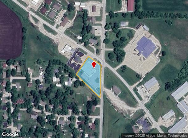
Property Record
71 S State Route F, Garden City, MO 64747
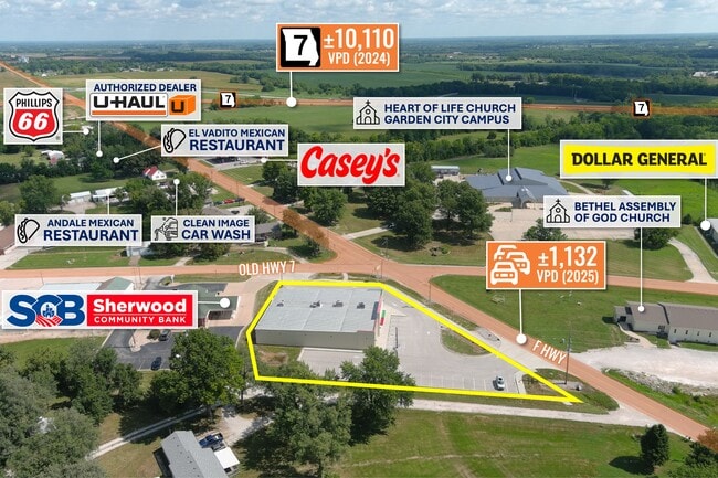
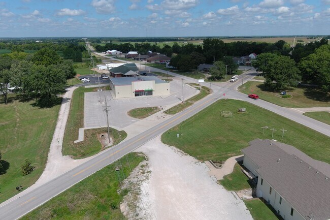
This Property Is For Sale
Current Lease Availabilities
NEARBY LISTINGS FOR SALE OR LEASE
Property Detail
71 S State Route F
0420003
BG SE CR NE N488 TPB NW360 NE221 SE193 S337 TB
Storebuilding
Cass
X
Missouri
29037C0330F
1.50 AC
2024
Cass County
2025
Kansas City
060700
Kansas City, MO-KS
10,580 SF
DEMOGRAPHICS near 71 S State Route F
1 Mile
3 Mile
5 Mile
2024 Total Population
1,674
2,412
3,263
2029 Population
1,801
2,594
3,501
Pop Growth 2024-2029
+ 7.59%
+ 7.55%
+ 7.29%
Average Age
38
40
41
2024 Total Households
663
951
1,285
HH Growth 2024-2029
+ 7.69%
+ 7.68%
+ 7.39%
Median Household Inc
$57,672
$62,581
$65,236
Avg Household Size
2.50
2.50
2.50
2024 Avg HH Vehicles
2.00
2.00
2.00
Median Home Value
$143,684
$168,333
$189,464
Median Year Built
1984
1984
1984
Nearby Places
Map Layers
Map Styles
 Street
 Aerial
- Restaurants
- Banks
- Shops
- Fitness
- Groceries
Nearby Properties
Address
Land Use
TOTAL SIZE
Lot Size
Zoning
Address
Land Use
TOTAL SIZE
Lot Size
Zoning
8,000 SF
5 AC
Address
Land Use
TOTAL SIZE
Lot Size
Zoning
20,340 SF
10 AC
Address
Land Use
TOTAL SIZE
Lot Size
Zoning
88,563 SF
13.72 AC
Address
Land Use
TOTAL SIZE
Lot Size
Zoning
64,320 SF
3.85 AC
Address
Land Use
TOTAL SIZE
Lot Size
Zoning
7,581 SF
53 AC
Address
Land Use
TOTAL SIZE
Lot Size
Zoning
12,129 SF
0.40 AC
Address
Land Use
TOTAL SIZE
Lot Size
Zoning
Address
Land Use
TOTAL SIZE
Lot Size
Zoning
Address
Land Use
TOTAL SIZE
Lot Size
Zoning
5,964 SF
9.15 AC
Address
Land Use
TOTAL SIZE
Lot Size
Zoning
9,020 SF
1.13 AC
Address
Land Use
TOTAL SIZE
Lot Size
Zoning
13,232 SF
1.38 AC
Address
Land Use
TOTAL SIZE
Lot Size
Zoning
6,720 SF
0.66 AC
Address
Land Use
TOTAL SIZE
Lot Size
Zoning
3,600 SF
0.85 AC
Address
Land Use
TOTAL SIZE
Lot Size
Zoning
2,368 SF
0.43 AC
Address
Land Use
TOTAL SIZE
Lot Size
Zoning
Address
Land Use
TOTAL SIZE
Lot Size
Zoning
6,465 SF
1.46 AC
Address
Land Use
TOTAL SIZE
Lot Size
Zoning
12,340 SF
1.24 AC
Address
Land Use
TOTAL SIZE
Lot Size
Zoning
7,440 SF
0.64 AC
Address
Land Use
TOTAL SIZE
Lot Size
Zoning
1.50 AC
Address
Land Use
TOTAL SIZE
Lot Size
Zoning
7,200 SF
1.56 AC
Address
Land Use
TOTAL SIZE
Lot Size
Zoning
2,644 SF
0.67 AC
Address
Land Use
TOTAL SIZE
Lot Size
Zoning
5,700 SF
0.32 AC
Address
Land Use
TOTAL SIZE
Lot Size
Zoning
6,585 SF
0.36 AC
Address
Land Use
TOTAL SIZE
Lot Size
Zoning
1,716 SF
0.14 AC
Address
Land Use
TOTAL SIZE
Lot Size
Zoning
2,964 SF
0.65 AC
Address
Land Use
TOTAL SIZE
Lot Size
Zoning
6,825 SF
0.60 AC
Address
Land Use
TOTAL SIZE
Lot Size
Zoning
0.09 AC
Address
Land Use
TOTAL SIZE
Lot Size
Zoning
19,146 SF
1.55 AC
Address
Land Use
TOTAL SIZE
Lot Size
Zoning
6,516 SF
2 AC
The World's #1 Commercial Real Estate Marketplace
Connect with us
© 2026 CoStar Group
The information above has been obtained from sources believed reliable. While we do not doubt its accuracy we have not verified it and make no guarantee, warranty or representation about it. It is your responsibility to independently confirm its accuracy and completeness. Any projections, opinions, assumptions, or estimates used are for example only and do not represent the current or future performance of the property. The value of this transaction to you depends on tax and other factors which should be evaluated by your tax, financial, and legal advisors. You and your advisors should conduct a careful, independent investigation of the property to determine to your satisfaction the suitability of the property for your needs.