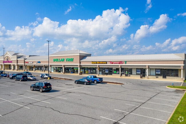
Property Record
71 S White Horse Pike, Hammonton, NJ 08037


Current Lease Availabilities
NEARBY LISTINGS FOR SALE OR LEASE
Property Detail
71 S White Horse Pike
Atlantic City-Hammonton, NJ
Incl
13-04604-0000-00032
B187L44
Regionalshoppingcenterormallwithanchorstore
Atlantic
X
New Jersey
34001C0018F
32
2024
9.27 AC
2025
Atlantic City/Hammonton
010900
Philadelphia
DEMOGRAPHICS near 71 S White Horse Pike
1 Mile
3 Mile
5 Mile
2024 Total Population
3,518
13,068
17,321
2029 Population
3,417
12,708
16,880
Pop Growth 2024-2029
(2.87%)
(2.75%)
(2.55%)
Average Age
42
41
42
2024 Total Households
1,304
4,721
6,174
HH Growth 2024-2029
(3.60%)
(3.50%)
(3.22%)
Median Household Inc
$71,148
$76,972
$80,559
Avg Household Size
2.60
2.60
2.60
2024 Avg HH Vehicles
2.00
2.00
2.00
Median Home Value
$299,999
$273,681
$268,818
Median Year Built
1974
1971
1971
Nearby Places
Map Layers
Map Styles
 Street
 Aerial
- Restaurants
- Banks
- Shops
- Fitness
- Groceries
PUBLIC TRANSPORTATION
COMMUTER RAIL
Hammonton (Atlantic City Line - NJ Transit Commuter Rail (NJ Transit))
DRIVE
WALK
Distance
Hammonton (Atlantic City Line - NJ Transit Commuter Rail (NJ Transit))
6 min
2.0 mi
AIRPORT
Atlantic City International
DRIVE
WALK
Distance
Atlantic City International
49 min
21.1 mi
Philadelphia International
DRIVE
WALK
Distance
Philadelphia International
53 min
37.0 mi
Freight Ports
Broadway Terminal - Pier 5
DRIVE
WALK
Distance
Broadway Terminal - Pier 5
38 min
28.5 mi
Nearby Properties
Address
Land Use
TOTAL SIZE
Lot Size
Zoning
Address
Land Use
TOTAL SIZE
Lot Size
Zoning
50.38 AC
Address
Land Use
TOTAL SIZE
Lot Size
Zoning
55.80 AC
Address
Land Use
TOTAL SIZE
Lot Size
Zoning
35.12 AC
Address
Land Use
TOTAL SIZE
Lot Size
Zoning
28.33 AC
R-3
Address
Land Use
TOTAL SIZE
Lot Size
Zoning
43.26 AC
R-1
Address
Land Use
TOTAL SIZE
Lot Size
Zoning
3,500 SF
4.77 AC
Address
Land Use
TOTAL SIZE
Lot Size
Zoning
Address
Land Use
TOTAL SIZE
Lot Size
Zoning
2,528 SF
21.85 AC
Address
Land Use
TOTAL SIZE
Lot Size
Zoning
Address
Land Use
TOTAL SIZE
Lot Size
Zoning
14.85 AC
Address
Land Use
TOTAL SIZE
Lot Size
Zoning
Address
Land Use
TOTAL SIZE
Lot Size
Zoning
16.92 AC
Address
Land Use
TOTAL SIZE
Lot Size
Zoning
67,563 SF
13.73 AC
Address
Land Use
TOTAL SIZE
Lot Size
Zoning
0.92 AC
Address
Land Use
TOTAL SIZE
Lot Size
Zoning
27.35 AC
PA
Address
Land Use
TOTAL SIZE
Lot Size
Zoning
Address
Land Use
TOTAL SIZE
Lot Size
Zoning
43,282 SF
1.58 AC
Address
Land Use
TOTAL SIZE
Lot Size
Zoning
26,277 SF
1 AC
Address
Land Use
TOTAL SIZE
Lot Size
Zoning
2,190 SF
7.20 AC
Address
Land Use
TOTAL SIZE
Lot Size
Zoning
Address
Land Use
TOTAL SIZE
Lot Size
Zoning
10.91 AC
Address
Land Use
TOTAL SIZE
Lot Size
Zoning
10,520 SF
7.76 AC
Address
Land Use
TOTAL SIZE
Lot Size
Zoning
Address
Land Use
TOTAL SIZE
Lot Size
Zoning
7.14 AC
R-1
Address
Land Use
TOTAL SIZE
Lot Size
Zoning
Address
Land Use
TOTAL SIZE
Lot Size
Zoning
22.49 AC
Address
Land Use
TOTAL SIZE
Lot Size
Zoning
81.61 AC
Address
Land Use
TOTAL SIZE
Lot Size
Zoning
Address
Land Use
TOTAL SIZE
Lot Size
Zoning
12,580 SF
9.89 AC
R-1
The World's #1 Commercial Real Estate Marketplace
Connect with us
© 2025 CoStar Group
The information above has been obtained from sources believed reliable. While we do not doubt its accuracy we have not verified it and make no guarantee, warranty or representation about it. It is your responsibility to independently confirm its accuracy and completeness. Any projections, opinions, assumptions, or estimates used are for example only and do not represent the current or future performance of the property. The value of this transaction to you depends on tax and other factors which should be evaluated by your tax, financial, and legal advisors. You and your advisors should conduct a careful, independent investigation of the property to determine to your satisfaction the suitability of the property for your needs.