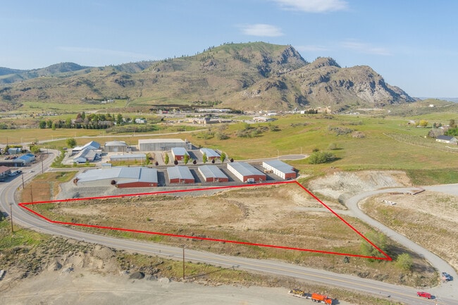
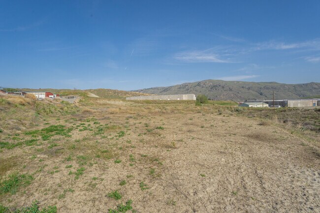
Property Record
71 Highway 150, Chelan, WA 98816

NEARBY LISTINGS FOR SALE OR LEASE
-
-
View all Chelan listings for sale on LoopNet.com
Property Detail
71 Highway 150
Wenatchee-East Wenatchee, WA
T 27N R 23EWM S 18 NE1/4 NWSESE 3.9100 ACRES NE1/4 NWSESE
46559
Chelan
Agriculturalland
Washington
2024
3.91 AC
2024
Washington State Area
960303
Other Market Areas
DEMOGRAPHICS near 71 Highway 150
1 Mile
3 Mile
5 Mile
2024 Total Population
658
4,129
6,239
2029 Population
650
4,175
6,398
Pop Growth 2024-2029
(1.22%)
+ 1.11%
+ 2.55%
Average Age
42
42
43
2024 Total Households
270
1,621
2,435
HH Growth 2024-2029
(1.11%)
+ 1.05%
+ 2.55%
Median Household Inc
$64,745
$60,345
$63,848
Avg Household Size
2.40
2.50
2.50
2024 Avg HH Vehicles
2.00
2.00
2.00
Median Home Value
$336,111
$370,945
$449,549
Median Year Built
1958
1985
1987
Nearby Places
Map Layers
Map Styles
 Street
 Aerial
- Restaurants
- Banks
- Shops
- Fitness
- Groceries
PUBLIC TRANSPORTATION
AIRPORT
Pangborn Memorial
DRIVE
WALK
Distance
Pangborn Memorial
68 min
45.2 mi
SALE & LEASE HISTORY
LISTING DATE
SALE/LEASE

May 09, 2023
For Sale
Nearby Properties
Address
Land Use
TOTAL SIZE
Lot Size
Zoning
Address
Land Use
TOTAL SIZE
Lot Size
Zoning
710,240 SF
60.95 AC
Address
Land Use
TOTAL SIZE
Lot Size
Zoning
118,660 SF
9.25 AC
Address
Land Use
TOTAL SIZE
Lot Size
Zoning
227,150 SF
34.55 AC
RR-5
Address
Land Use
TOTAL SIZE
Lot Size
Zoning
128,041 SF
9.54 AC
Address
Land Use
TOTAL SIZE
Lot Size
Zoning
42,056 SF
6.81 AC
Address
Land Use
TOTAL SIZE
Lot Size
Zoning
21,226 SF
3 AC
Address
Land Use
TOTAL SIZE
Lot Size
Zoning
15,544 SF
0.41 AC
Address
Land Use
TOTAL SIZE
Lot Size
Zoning
19,697 SF
3.82 AC
Address
Land Use
TOTAL SIZE
Lot Size
Zoning
7,574 SF
10.11 AC
Address
Land Use
TOTAL SIZE
Lot Size
Zoning
73,357 SF
4.69 AC
Address
Land Use
TOTAL SIZE
Lot Size
Zoning
14,744 SF
355.92 AC
AC-10
Address
Land Use
TOTAL SIZE
Lot Size
Zoning
21,680 SF
3.55 AC
Address
Land Use
TOTAL SIZE
Lot Size
Zoning
20,637 SF
2.78 AC
Address
Land Use
TOTAL SIZE
Lot Size
Zoning
21,045 SF
0.74 AC
Address
Land Use
TOTAL SIZE
Lot Size
Zoning
21,200 SF
2.61 AC
Address
Land Use
TOTAL SIZE
Lot Size
Zoning
8.24 AC
Address
Land Use
TOTAL SIZE
Lot Size
Zoning
4,264 SF
1.18 AC
Address
Land Use
TOTAL SIZE
Lot Size
Zoning
6,048 SF
0.91 AC
Address
Land Use
TOTAL SIZE
Lot Size
Zoning
38,020 SF
2.14 AC
Address
Land Use
TOTAL SIZE
Lot Size
Zoning
13,205 SF
0.17 AC
Address
Land Use
TOTAL SIZE
Lot Size
Zoning
0.86 AC
Address
Land Use
TOTAL SIZE
Lot Size
Zoning
19,031 SF
1.79 AC
Address
Land Use
TOTAL SIZE
Lot Size
Zoning
780 SF
1.21 AC
Address
Land Use
TOTAL SIZE
Lot Size
Zoning
29,707 SF
1.53 AC
Address
Land Use
TOTAL SIZE
Lot Size
Zoning
52,560 SF
1.46 AC
Address
Land Use
TOTAL SIZE
Lot Size
Zoning
14,602 SF
1.06 AC
Address
Land Use
TOTAL SIZE
Lot Size
Zoning
11,000 SF
0.13 AC
Address
Land Use
TOTAL SIZE
Lot Size
Zoning
37,994 SF
0.83 AC
Address
Land Use
TOTAL SIZE
Lot Size
Zoning
2,128 SF
0.09 AC
Address
Land Use
TOTAL SIZE
Lot Size
Zoning
11,280 SF
0.53 AC
The World's #1 Commercial Real Estate Marketplace
Connect with us
© 2026 CoStar Group
The information above has been obtained from sources believed reliable. While we do not doubt its accuracy we have not verified it and make no guarantee, warranty or representation about it. It is your responsibility to independently confirm its accuracy and completeness. Any projections, opinions, assumptions, or estimates used are for example only and do not represent the current or future performance of the property. The value of this transaction to you depends on tax and other factors which should be evaluated by your tax, financial, and legal advisors. You and your advisors should conduct a careful, independent investigation of the property to determine to your satisfaction the suitability of the property for your needs.