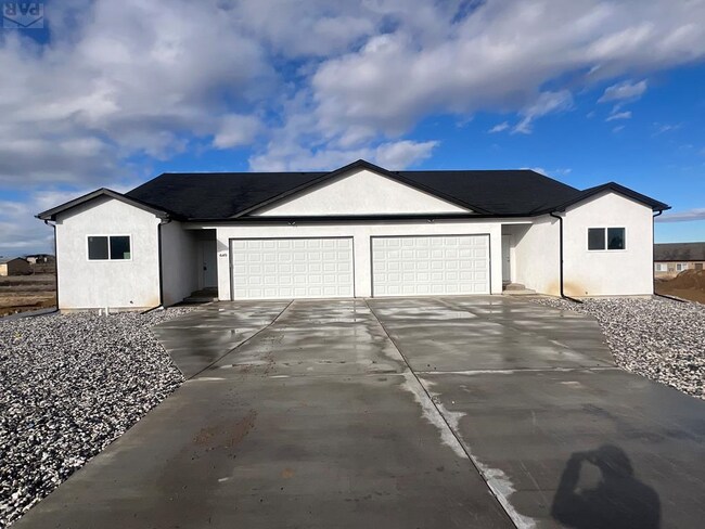
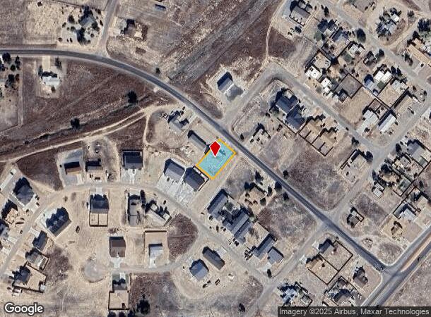
Property Record
710 E Hahns Peak Ave, Pueblo, CO 81007
NEARBY LISTINGS FOR SALE OR LEASE
Property Detail
710 E Hahns Peak Ave
Pueblo, CO
Pueblo West
0-5-07-0-18-028
LOT 28 BLK 5 TR 380 PUEBLO WEST
Multifamilyacreage
Pueblo
X
Colorado
08101C0479D
28
2024
0.31 AC
2024
Colorado East Area
002914
Other Market Areas
3,706 SF
DEMOGRAPHICS near 710 E Hahns Peak Ave
1 Mile
3 Mile
5 Mile
2024 Total Population
2,238
20,070
48,183
2029 Population
2,273
20,522
49,519
Pop Growth 2024-2029
+ 1.56%
+ 2.25%
+ 2.77%
Average Age
38
40
41
2024 Total Households
789
7,512
18,694
HH Growth 2024-2029
+ 1.65%
+ 2.32%
+ 2.88%
Median Household Inc
$76,520
$80,036
$71,911
Avg Household Size
2.70
2.60
2.50
2024 Avg HH Vehicles
2.00
2.00
2.00
Median Home Value
$326,050
$293,866
$290,625
Median Year Built
1993
1996
1996
Nearby Places
Map Layers
Map Styles
 Street
 Aerial
- Restaurants
- Banks
- Shops
- Fitness
- Groceries
PUBLIC TRANSPORTATION
AIRPORT
City of Colorado Springs Municipal
DRIVE
WALK
Distance
City of Colorado Springs Municipal
63 min
48.9 mi
SALE & LEASE HISTORY
LISTING DATE
SALE/LEASE

Feb 20, 2025
For Sale
Nearby Properties
Address
Land Use
TOTAL SIZE
Lot Size
Zoning
Address
Land Use
TOTAL SIZE
Lot Size
Zoning
78,127 SF
34.84 AC
R-5
Address
Land Use
TOTAL SIZE
Lot Size
Zoning
60,593 SF
12.69 AC
Address
Land Use
TOTAL SIZE
Lot Size
Zoning
221,954 SF
24.02 AC
B-4
Address
Land Use
TOTAL SIZE
Lot Size
Zoning
15,284 SF
4.50 AC
R6:RES/MUL
Address
Land Use
TOTAL SIZE
Lot Size
Zoning
33,098 SF
5 AC
B4:COMM/RE
Address
Land Use
TOTAL SIZE
Lot Size
Zoning
34,494 SF
3.87 AC
R5:RES/MUL
Address
Land Use
TOTAL SIZE
Lot Size
Zoning
104,405 SF
8.17 AC
A2:AG/1&2
Address
Land Use
TOTAL SIZE
Lot Size
Zoning
8,166 SF
8.27 AC
R-6
Address
Land Use
TOTAL SIZE
Lot Size
Zoning
79,400 SF
5.83 AC
I-2
Address
Land Use
TOTAL SIZE
Lot Size
Zoning
7,495 SF
2.99 AC
R5:RES/MUL
Address
Land Use
TOTAL SIZE
Lot Size
Zoning
51,856 SF
6.01 AC
Address
Land Use
TOTAL SIZE
Lot Size
Zoning
3,146 SF
46.55 AC
S1:SPC/PUB
Address
Land Use
TOTAL SIZE
Lot Size
Zoning
107,280 SF
6.22 AC
I-2
Address
Land Use
TOTAL SIZE
Lot Size
Zoning
37.11 AC
S1:SPC/PUB
Address
Land Use
TOTAL SIZE
Lot Size
Zoning
33.01 AC
S1:SPC/PUB
Address
Land Use
TOTAL SIZE
Lot Size
Zoning
22,077 SF
13.98 AC
S1:SPC/PUB
Address
Land Use
TOTAL SIZE
Lot Size
Zoning
29,720 SF
2.28 AC
B4:COMM/RE
Address
Land Use
TOTAL SIZE
Lot Size
Zoning
152,286 SF
6.29 AC
Address
Land Use
TOTAL SIZE
Lot Size
Zoning
30.47 AC
S1:SPC/PUB
Address
Land Use
TOTAL SIZE
Lot Size
Zoning
10,030 SF
1.72 AC
B4:COMM/RE
Address
Land Use
TOTAL SIZE
Lot Size
Zoning
20.39 AC
I2:IND/MAN
Address
Land Use
TOTAL SIZE
Lot Size
Zoning
56,140 SF
5.60 AC
B4:COMM/RE
Address
Land Use
TOTAL SIZE
Lot Size
Zoning
19.74 AC
I2:IND/MAN
Address
Land Use
TOTAL SIZE
Lot Size
Zoning
54,100 SF
4.60 AC
I2:IND/MAN
Address
Land Use
TOTAL SIZE
Lot Size
Zoning
29,933 SF
2.20 AC
B4:COMM/RE
Address
Land Use
TOTAL SIZE
Lot Size
Zoning
19.41 AC
I2:IND/MAN
Address
Land Use
TOTAL SIZE
Lot Size
Zoning
32.46 AC
B4:COMM/RE
Address
Land Use
TOTAL SIZE
Lot Size
Zoning
66,890 SF
4.21 AC
B4:COMM/RE
Address
Land Use
TOTAL SIZE
Lot Size
Zoning
5,682 SF
4.23 AC
R6:RES/MUL
Address
Land Use
TOTAL SIZE
Lot Size
Zoning
15,633 SF
0.36 AC
B4:COMM/RE
The World's #1 Commercial Real Estate Marketplace
Connect with us
© 2026 CoStar Group
The information above has been obtained from sources believed reliable. While we do not doubt its accuracy we have not verified it and make no guarantee, warranty or representation about it. It is your responsibility to independently confirm its accuracy and completeness. Any projections, opinions, assumptions, or estimates used are for example only and do not represent the current or future performance of the property. The value of this transaction to you depends on tax and other factors which should be evaluated by your tax, financial, and legal advisors. You and your advisors should conduct a careful, independent investigation of the property to determine to your satisfaction the suitability of the property for your needs.