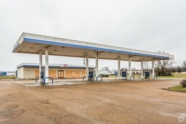
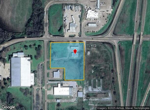
Property Record
710 Highway 35 N, Batesville, MS 38606

NEARBY LISTINGS FOR SALE OR LEASE
Property Detail
710 Highway 35 N
Conveniencestore
4.3 AC PT NE 1/4 NE 1/4 SE 1/4
X
Panola
28107C0310D
Mississippi
2024
4.30 AC
2024
Other Market Areas
950601
3138-0004803-0000218
3,320 SF
DEMOGRAPHICS near 710 Highway 35 N
1 Mile
3 Mile
5 Mile
2024 Total Population
14
3,542
9,814
2029 Population
13
3,438
9,589
Pop Growth 2024-2029
(7.14%)
(2.94%)
(2.29%)
Average Age
37
40
39
2024 Total Households
5
1,377
3,682
HH Growth 2024-2029
0.00%
(2.83%)
(2.28%)
Median Household Inc
$22,500
$57,083
$42,333
Avg Household Size
2.40
2.50
2.60
2024 Avg HH Vehicles
2.00
2.00
2.00
Median Home Value
$125,000
$148,191
$136,584
Median Year Built
1999
1989
1985
Nearby Places
Map Layers
Map Styles
 Street
 Aerial
- Restaurants
- Banks
- Shops
- Fitness
- Groceries
SALE & LEASE HISTORY
LISTING DATE
SALE/LEASE

Feb 09, 2017
For Sale
Nearby Properties
Address
Land Use
TOTAL SIZE
Lot Size
Zoning
Address
Land Use
TOTAL SIZE
Lot Size
Zoning
138,838 SF
14.30 AC
Address
Land Use
TOTAL SIZE
Lot Size
Zoning
9,911 SF
9.80 AC
Address
Land Use
TOTAL SIZE
Lot Size
Zoning
5,802 SF
11.50 AC
Address
Land Use
TOTAL SIZE
Lot Size
Zoning
4,120 SF
39 AC
Address
Land Use
TOTAL SIZE
Lot Size
Zoning
108,001 SF
13.10 AC
Address
Land Use
TOTAL SIZE
Lot Size
Zoning
Address
Land Use
TOTAL SIZE
Lot Size
Zoning
97,155 SF
14.20 AC
Address
Land Use
TOTAL SIZE
Lot Size
Zoning
5,901 SF
7 AC
Address
Land Use
TOTAL SIZE
Lot Size
Zoning
7,492 SF
45.50 AC
Address
Land Use
TOTAL SIZE
Lot Size
Zoning
2.20 AC
Address
Land Use
TOTAL SIZE
Lot Size
Zoning
49,248 SF
2.40 AC
Address
Land Use
TOTAL SIZE
Lot Size
Zoning
10,530 SF
12 AC
Address
Land Use
TOTAL SIZE
Lot Size
Zoning
41,413 SF
2.80 AC
Address
Land Use
TOTAL SIZE
Lot Size
Zoning
20,172 SF
2.10 AC
Address
Land Use
TOTAL SIZE
Lot Size
Zoning
88,114 SF
10.30 AC
Address
Land Use
TOTAL SIZE
Lot Size
Zoning
29,333 SF
1.80 AC
Address
Land Use
TOTAL SIZE
Lot Size
Zoning
42,389 SF
12.70 AC
Address
Land Use
TOTAL SIZE
Lot Size
Zoning
15,086 SF
1.80 AC
Address
Land Use
TOTAL SIZE
Lot Size
Zoning
8,554 SF
22.70 AC
Address
Land Use
TOTAL SIZE
Lot Size
Zoning
27,603 SF
3.80 AC
Address
Land Use
TOTAL SIZE
Lot Size
Zoning
11,545 SF
2.60 AC
Address
Land Use
TOTAL SIZE
Lot Size
Zoning
6,031 SF
0.96 AC
Address
Land Use
TOTAL SIZE
Lot Size
Zoning
2,664 SF
1.90 AC
Address
Land Use
TOTAL SIZE
Lot Size
Zoning
10,920 SF
2.90 AC
The World's #1 Commercial Real Estate Marketplace
Connect with us
© 2025 CoStar Group
The information above has been obtained from sources believed reliable. While we do not doubt its accuracy we have not verified it and make no guarantee, warranty or representation about it. It is your responsibility to independently confirm its accuracy and completeness. Any projections, opinions, assumptions, or estimates used are for example only and do not represent the current or future performance of the property. The value of this transaction to you depends on tax and other factors which should be evaluated by your tax, financial, and legal advisors. You and your advisors should conduct a careful, independent investigation of the property to determine to your satisfaction the suitability of the property for your needs.