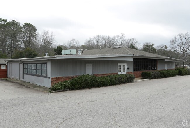
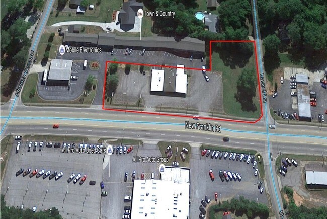
Property Record
710 New Franklin Rd, Lagrange, GA 30240
NEARBY LISTINGS FOR SALE OR LEASE
Property Detail
710 New Franklin Rd
LaGrange, GA-AL
Summer Heights
050-2B-005-028
700 NEW FRANKLIN RD/ TR 6 BLK
Restaurantbuilding
Troup
X
Georgia
13285C0142E
6
2024
0.61 AC
2025
Troup County
960501
Columbus GA
5,599 SF
DEMOGRAPHICS near 710 New Franklin Rd
1 Mile
3 Mile
5 Mile
2024 Total Population
6,378
30,016
39,050
2029 Population
6,349
30,550
39,710
Pop Growth 2024-2029
(0.45%)
+ 1.78%
+ 1.69%
Average Age
37
38
38
2024 Total Households
2,664
11,763
15,159
HH Growth 2024-2029
(0.49%)
+ 1.79%
+ 1.71%
Median Household Inc
$42,110
$44,540
$46,404
Avg Household Size
2.40
2.50
2.50
2024 Avg HH Vehicles
1.00
2.00
2.00
Median Home Value
$153,975
$154,006
$167,597
Median Year Built
1976
1979
1982
Nearby Places
Map Layers
Map Styles
 Street
 Aerial
- Restaurants
- Banks
- Shops
- Fitness
- Groceries
SALE & LEASE HISTORY
LISTING DATE
SALE/LEASE

Sep 24, 2016
For Sale
Jun 22, 2017
For Sale
Nearby Properties
Address
Land Use
TOTAL SIZE
Lot Size
Zoning
Address
Land Use
TOTAL SIZE
Lot Size
Zoning
2,095 SF
16.50 AC
16- CP-GB
Address
Land Use
TOTAL SIZE
Lot Size
Zoning
17,328 SF
10.66 AC
16- CP-GB
Address
Land Use
TOTAL SIZE
Lot Size
Zoning
35,269 SF
22.34 AC
16- CR-MR
Address
Land Use
TOTAL SIZE
Lot Size
Zoning
28,575 SF
45.67 AC
16- CR-MX
Address
Land Use
TOTAL SIZE
Lot Size
Zoning
109,533 SF
1.80 AC
16- DT-MX
Address
Land Use
TOTAL SIZE
Lot Size
Zoning
117,684 SF
12.61 AC
16- AC-MX
Address
Land Use
TOTAL SIZE
Lot Size
Zoning
174,899 SF
7.52 AC
16- TN-R
Address
Land Use
TOTAL SIZE
Lot Size
Zoning
121,889 SF
8.99 AC
16- CR-MX
Address
Land Use
TOTAL SIZE
Lot Size
Zoning
2,152 SF
21.70 AC
16- CR-MR
Address
Land Use
TOTAL SIZE
Lot Size
Zoning
551,306 SF
72.64 AC
16- CP-GI
Address
Land Use
TOTAL SIZE
Lot Size
Zoning
141,328 SF
7.18 AC
16- TN-MX
Address
Land Use
TOTAL SIZE
Lot Size
Zoning
159,645 SF
2.98 AC
16- DT-MX
Address
Land Use
TOTAL SIZE
Lot Size
Zoning
8,448 SF
25.78 AC
16- CR-MX
Address
Land Use
TOTAL SIZE
Lot Size
Zoning
29,520 SF
1.92 AC
16- CP-GB
Address
Land Use
TOTAL SIZE
Lot Size
Zoning
26,595 SF
20.13 AC
16- CR-MX
Address
Land Use
TOTAL SIZE
Lot Size
Zoning
3,798 SF
22.81 AC
16- CR-MR
Address
Land Use
TOTAL SIZE
Lot Size
Zoning
89,395 SF
28.47 AC
16- TN-R
Address
Land Use
TOTAL SIZE
Lot Size
Zoning
56,620 SF
5.22 AC
16- CR-MX
Address
Land Use
TOTAL SIZE
Lot Size
Zoning
82,725 SF
5.98 AC
16- TN-R
Address
Land Use
TOTAL SIZE
Lot Size
Zoning
22,600 SF
15.57 AC
16- CR-MX
Address
Land Use
TOTAL SIZE
Lot Size
Zoning
9,290 SF
11.58 AC
16- CP-GB
Address
Land Use
TOTAL SIZE
Lot Size
Zoning
3,433 SF
19.65 AC
16- CR-MR
Address
Land Use
TOTAL SIZE
Lot Size
Zoning
56,580 SF
12.87 AC
16- CR-MX
Address
Land Use
TOTAL SIZE
Lot Size
Zoning
4,428 SF
9.67 AC
16- CR-MR
Address
Land Use
TOTAL SIZE
Lot Size
Zoning
8,752 SF
13.43 AC
16- CR-MR
Address
Land Use
TOTAL SIZE
Lot Size
Zoning
2,366 SF
8.70 AC
16- CR-MR
Address
Land Use
TOTAL SIZE
Lot Size
Zoning
14,232 SF
2.59 AC
16- DT-MX
Address
Land Use
TOTAL SIZE
Lot Size
Zoning
57,971 SF
7.98 AC
16- CP-GB
Address
Land Use
TOTAL SIZE
Lot Size
Zoning
133,950 SF
1.94 AC
16- DT-MX
Address
Land Use
TOTAL SIZE
Lot Size
Zoning
34,409 SF
12.40 AC
16- TN-R
The World's #1 Commercial Real Estate Marketplace
Connect with us
© 2026 CoStar Group
The information above has been obtained from sources believed reliable. While we do not doubt its accuracy we have not verified it and make no guarantee, warranty or representation about it. It is your responsibility to independently confirm its accuracy and completeness. Any projections, opinions, assumptions, or estimates used are for example only and do not represent the current or future performance of the property. The value of this transaction to you depends on tax and other factors which should be evaluated by your tax, financial, and legal advisors. You and your advisors should conduct a careful, independent investigation of the property to determine to your satisfaction the suitability of the property for your needs.