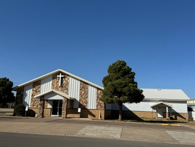
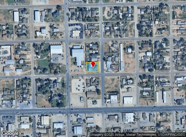
Property Record
710 S Baird St, Midland, TX 79701
Property Detail
710 S Baird St
Other Market Areas
Southern
Midland, TX
ACRES: 0.328 BLK: 157 LOT: 008 S.2 & ALL OF ADDN: SOUTHERN LOTS 9 THRU 12
R000045-819
Midland
Sfr
Texas
2025
8
2025
0.33 AC
001400
Midland & Odessa
5,337 SF
NEARBY LISTINGS FOR SALE OR LEASE
DEMOGRAPHICS near 710 S Baird St
1 mile
3 mile
5 mile
2024 Total Population
8,417
51,487
115,759
2029 Population
8,641
52,447
118,456
Pop Growth 2024-2029
+ 2.66%
+ 1.86%
+ 2.33%
Average Age
34
35
35
2024 Total Households
2,552
17,783
42,008
HH Growth 2024-2029
+ 2.98%
+ 2.15%
+ 2.68%
Median Household Inc
$47,465
$57,523
$73,085
Avg Household Size
3.00
2.80
2.70
2024 Avg HH Vehicles
2.00
2.00
2.00
Median Home Value
$182,149
$232,998
$254,356
Median Year Built
1970
1967
1981
Nearby Places
Map Layers
Map Styles
 Street
 Aerial
Transit
 Traffic
 Biking
Places
Listings with unknown addresses are not visible on the map
- Restaurants
- Banks
- Shops
- Fitness
- Groceries
PUBLIC TRANSPORTATION
AIRPORT
Midland International Air And Space Port
Drive
Walk
Distance
Midland International Air And Space Port
17 min
10.7 mi
Freight Ports
Calhoun Port
Drive
Walk
Distance
Calhoun Port
522 min
470.7 mi
SALE & LEASE HISTORY
LISTING DATE
SALE/LEASE

Nov 12, 2024
For Sale
Apr 07, 2025
For Sale
Nearby Properties
Address
Land Use
TOTAL SIZE
Lot Size
Zoning
Address
Land Use
TOTAL SIZE
Lot Size
Zoning
15,052 SF
4.68 AC
C1
Address
Land Use
TOTAL SIZE
Lot Size
Zoning
245,203 SF
18.40 AC
Address
Land Use
TOTAL SIZE
Lot Size
Zoning
94,059 SF
15.95 AC
PDMX
Address
Land Use
TOTAL SIZE
Lot Size
Zoning
176,175 SF
16.85 AC
Address
Land Use
TOTAL SIZE
Lot Size
Zoning
29,645 SF
2.07 AC
C1
Address
Land Use
TOTAL SIZE
Lot Size
Zoning
10,228 SF
15.98 AC
Address
Land Use
TOTAL SIZE
Lot Size
Zoning
8,004 SF
3.58 AC
C1
Address
Land Use
TOTAL SIZE
Lot Size
Zoning
133,056 SF
2.07 AC
C1
Address
Land Use
TOTAL SIZE
Lot Size
Zoning
46,010 SF
13.02 AC
PDOC
Address
Land Use
TOTAL SIZE
Lot Size
Zoning
7,200 SF
2.07 AC
C1
Address
Land Use
TOTAL SIZE
Lot Size
Zoning
46,512 SF
0.96 AC
C1
Address
Land Use
TOTAL SIZE
Lot Size
Zoning
96,390 SF
0.96 AC
C1
Address
Land Use
TOTAL SIZE
Lot Size
Zoning
7,008 SF
0.96 AC
C1
Address
Land Use
TOTAL SIZE
Lot Size
Zoning
13.73 AC
Address
Land Use
TOTAL SIZE
Lot Size
Zoning
41,790 SF
1.50 AC
C1
Address
Land Use
TOTAL SIZE
Lot Size
Zoning
12.91 AC
Address
Land Use
TOTAL SIZE
Lot Size
Zoning
800 SF
75.53 AC
Address
Land Use
TOTAL SIZE
Lot Size
Zoning
276 SF
0.48 AC
C1
Address
Land Use
TOTAL SIZE
Lot Size
Zoning
97,700 SF
10.79 AC
Address
Land Use
TOTAL SIZE
Lot Size
Zoning
161,148 SF
3.83 AC
MF2
Address
Land Use
TOTAL SIZE
Lot Size
Zoning
26,390 SF
1.01 AC
C1
Address
Land Use
TOTAL SIZE
Lot Size
Zoning
21,609 SF
5.45 AC
O2
Address
Land Use
TOTAL SIZE
Lot Size
Zoning
86,922 SF
1.87 AC
PDMC
Address
Land Use
TOTAL SIZE
Lot Size
Zoning
6,510 SF
0.48 AC
C1
Address
Land Use
TOTAL SIZE
Lot Size
Zoning
218,900 SF
0.40 AC
C1
Address
Land Use
TOTAL SIZE
Lot Size
Zoning
1,116 SF
0.56 AC
C1
Address
Land Use
TOTAL SIZE
Lot Size
Zoning
9,650 SF
13 AC
MF1
Address
Land Use
TOTAL SIZE
Lot Size
Zoning
215,322 SF
19.80 AC
PDSC
Address
Land Use
TOTAL SIZE
Lot Size
Zoning
112,449 SF
8 AC
MF1
Address
Land Use
TOTAL SIZE
Lot Size
Zoning
103,500 SF
0.20 AC
C1
The World's #1 Commercial Real Estate Marketplace
Connect with us
© 2026 CoStar Group
The information above has been obtained from sources believed reliable. While we do not doubt its accuracy we have not verified it and make no guarantee, warranty or representation about it. It is your responsibility to independently confirm its accuracy and completeness. Any projections, opinions, assumptions, or estimates used are for example only and do not represent the current or future performance of the property. The value of this transaction to you depends on tax and other factors which should be evaluated by your tax, financial, and legal advisors. You and your advisors should conduct a careful, independent investigation of the property to determine to your satisfaction the suitability of the property for your needs.