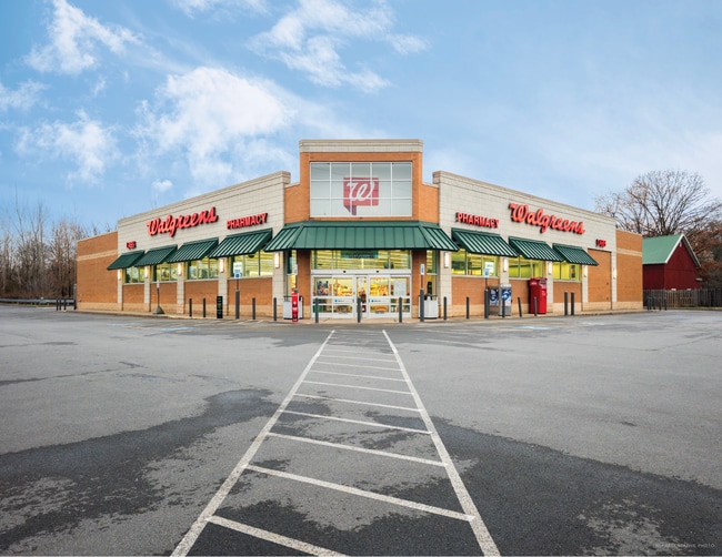
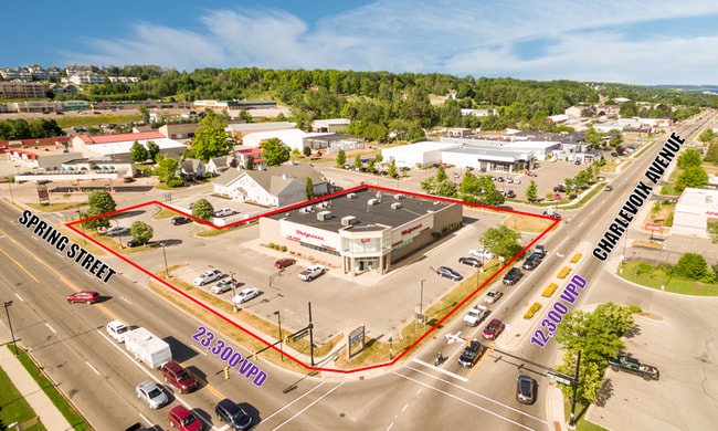
Property Record
710 Spring St, Petoskey, MI 49770

Property Detail
710 Spring St
52-19-06-300-090
COM 33 FT W & 33 FT S OF NE COR OF NW ? OF SW ? OF SECTION 6, TH W 300 FT, TH S210 FT, TH E 300 FT, TH N 210 FT TO POB. EXC A
Commercialnec
Emmet
COP B-3
Michigan
2024
1.58 AC
2025
Michigan North Central Area
970800
Other Market Areas
13,929 SF
Petoskey, MI
NEARBY LISTINGS FOR SALE OR LEASE
DEMOGRAPHICS near 710 Spring St
1 mile
3 mile
5 mile
2025 Total Population
3,214
8,398
14,862
2030 Population
3,068
8,048
14,682
Pop Growth 2025-2030
(4.54%)
(4.17%)
(1.21%)
Average Age
44
43
45
2025 Total Households
1,544
3,891
6,744
HH Growth 2025-2030
(5.12%)
(4.50%)
(1.17%)
Median Household Inc
$66,305
$69,575
$73,940
Avg Household Size
1.90
2.00
2.10
2025 Avg HH Vehicles
2.00
2.00
2.00
Median Home Value
$309,836
$355,125
$368,708
Median Year Built
1978
1977
1979
Nearby Places
Map Layers
Map Styles
 Street
 Aerial
Layers
 Traffic
 Biking
Places
Listings with unknown addresses are not visible on the map
- Restaurants
- Banks
- Shops
- Fitness
- Groceries
SALE & LEASE HISTORY
LISTING DATE
SALE/LEASE

Jan 28, 2020
For Sale
Dec 05, 2024
For Sale
Nearby Properties
Address
Land Use
TOTAL SIZE
Lot Size
Zoning
Address
Land Use
TOTAL SIZE
Lot Size
Zoning
Address
Land Use
TOTAL SIZE
Lot Size
Zoning
4.68 AC
RT PUD-2
Address
Land Use
TOTAL SIZE
Lot Size
Zoning
17.22 AC
COP B-3
Address
Land Use
TOTAL SIZE
Lot Size
Zoning
21.71 AC
EC FF-1
Address
Land Use
TOTAL SIZE
Lot Size
Zoning
13.88 AC
EC FF-1
Address
Land Use
TOTAL SIZE
Lot Size
Zoning
19.09 AC
COP PUD
Address
Land Use
TOTAL SIZE
Lot Size
Zoning
213,838 SF
21.02 AC
EC R-1
Address
Land Use
TOTAL SIZE
Lot Size
Zoning
31,545 SF
6.10 AC
COP RM-1
Address
Land Use
TOTAL SIZE
Lot Size
Zoning
1.43 AC
COP B-2
Address
Land Use
TOTAL SIZE
Lot Size
Zoning
23.70 AC
EC B-2
Address
Land Use
TOTAL SIZE
Lot Size
Zoning
137,452 SF
14.69 AC
EC B-2
Address
Land Use
TOTAL SIZE
Lot Size
Zoning
11.64 AC
EC R-2
Address
Land Use
TOTAL SIZE
Lot Size
Zoning
1.76 AC
COP PUD
Address
Land Use
TOTAL SIZE
Lot Size
Zoning
15.50 AC
EC R-1
Address
Land Use
TOTAL SIZE
Lot Size
Zoning
15.19 AC
EC R-1
Address
Land Use
TOTAL SIZE
Lot Size
Zoning
2 AC
EC R-2
Address
Land Use
TOTAL SIZE
Lot Size
Zoning
2.71 AC
COP B-3
Address
Land Use
TOTAL SIZE
Lot Size
Zoning
3,118 SF
2.89 AC
RT R-2B
Address
Land Use
TOTAL SIZE
Lot Size
Zoning
2.33 AC
RT FF
Address
Land Use
TOTAL SIZE
Lot Size
Zoning
1.25 AC
COP B-3
Address
Land Use
TOTAL SIZE
Lot Size
Zoning
7.38 AC
EC FF-1
Address
Land Use
TOTAL SIZE
Lot Size
Zoning
0.45 AC
EC R-2
Address
Land Use
TOTAL SIZE
Lot Size
Zoning
3.83 AC
COP PUD
Address
Land Use
TOTAL SIZE
Lot Size
Zoning
51,672 SF
1.80 AC
COP B-3
Address
Land Use
TOTAL SIZE
Lot Size
Zoning
71,808 SF
3.98 AC
RT I
Address
Land Use
TOTAL SIZE
Lot Size
Zoning
0.18 AC
COP B-2
Address
Land Use
TOTAL SIZE
Lot Size
Zoning
0.19 AC
RT PUD-2
Address
Land Use
TOTAL SIZE
Lot Size
Zoning
4.85 AC
COP B-3B
Address
Land Use
TOTAL SIZE
Lot Size
Zoning
3.61 AC
EC PUD
Address
Land Use
TOTAL SIZE
Lot Size
Zoning
7.91 AC
EC R-1
The World's #1 Commercial Real Estate Marketplace
Connect with us
© 2026 CoStar Group
The information above has been obtained from sources believed reliable. While we do not doubt its accuracy we have not verified it and make no guarantee, warranty or representation about it. It is your responsibility to independently confirm its accuracy and completeness. Any projections, opinions, assumptions, or estimates used are for example only and do not represent the current or future performance of the property. The value of this transaction to you depends on tax and other factors which should be evaluated by your tax, financial, and legal advisors. You and your advisors should conduct a careful, independent investigation of the property to determine to your satisfaction the suitability of the property for your needs.