Property Record
18803 Sw Farm Rd, Indiantown, FL 34956

Property Detail
18803 Sw Farm Rd
Port St. Lucie, FL
THE SOUTH 1/2 OF THE SE 1/4 OF THE SW 1/4 OF 35-39-38 AND BEGINNING AT THE SOUTHEAST CORNER OF THE SW 1/4 OF THE SW 1/4 OF 35-39-38 THEN WESTERLY ALONG THE SOUTH LINE OF SECTION 35 FOR 151.8 FT M/L TO A CORNER ROW OF THE COUNTY RD RUN NORTHEASTERLY A
35-39-38-000-000-00030-8
MARTIN
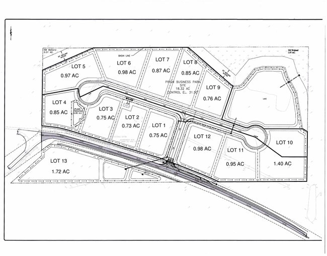
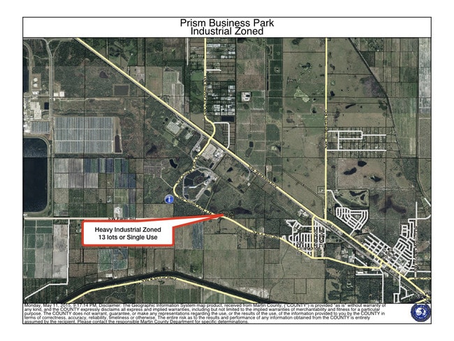
Industrialacreage
Florida
B and X Area of moderate flood hazard, usually the area between the limits of the 100-year and 500-year floods.
19.17 AC
2024
Martin Inland
2025
Port St Lucie/Fort Pierce
001803
NEARBY LISTINGS FOR SALE OR LEASE
DEMOGRAPHICS near 18803 Sw Farm Rd
1 mile
3 mile
5 mile
2025 Total Population
1,092
7,215
7,415
2030 Population
1,095
7,416
7,616
Pop Growth 2025-2030
+ 0.27%
+ 2.79%
+ 2.71%
Average Age
34
36
36
2025 Total Households
244
2,004
2,055
HH Growth 2025-2030
0.00%
+ 2.84%
+ 2.77%
Median Household Inc
$67,500
$54,517
$54,671
Avg Household Size
3.90
3.30
3.30
2025 Avg HH Vehicles
2.00
2.00
2.00
Median Home Value
$250,000
$209,155
$211,749
Median Year Built
1976
1984
1984
Nearby Places
Map Layers
Map Styles
 Street
 Aerial
Transit
 Traffic
 Biking
Places
Listings with unknown addresses are not visible on the map
- Restaurants
- Banks
- Shops
- Fitness
- Groceries
SALE & LEASE HISTORY
LISTING DATE
SALE/LEASE

Oct 25, 2019
For Sale
Nearby Properties
Address
Land Use
TOTAL SIZE
Lot Size
Zoning
Address
Land Use
TOTAL SIZE
Lot Size
Zoning
206,889 SF
76.77 AC
GI
Address
Land Use
TOTAL SIZE
Lot Size
Zoning
3,456 SF
20.12 AC
A2
Address
Land Use
TOTAL SIZE
Lot Size
Zoning
10.39 AC
Address
Land Use
TOTAL SIZE
Lot Size
Zoning
93,546 SF
22.05 AC
GI
Address
Land Use
TOTAL SIZE
Lot Size
Zoning
144.69 AC
M3
Address
Land Use
TOTAL SIZE
Lot Size
Zoning
105,069 SF
11.30 AC
PS
Address
Land Use
TOTAL SIZE
Lot Size
Zoning
44,656 SF
97.02 AC
Address
Land Use
TOTAL SIZE
Lot Size
Zoning
149.83 AC
Address
Land Use
TOTAL SIZE
Lot Size
Zoning
Address
Land Use
TOTAL SIZE
Lot Size
Zoning
35,723 SF
20 AC
RS6
Address
Land Use
TOTAL SIZE
Lot Size
Zoning
1.60 AC
RM10
Address
Land Use
TOTAL SIZE
Lot Size
Zoning
489 AC
A2
Address
Land Use
TOTAL SIZE
Lot Size
Zoning
80,279 SF
10.59 AC
M1
Address
Land Use
TOTAL SIZE
Lot Size
Zoning
Address
Land Use
TOTAL SIZE
Lot Size
Zoning
563.93 AC
AG20A
Address
Land Use
TOTAL SIZE
Lot Size
Zoning
22,014 SF
0.79 AC
Address
Land Use
TOTAL SIZE
Lot Size
Zoning
1,168 SF
28.75 AC
WGC
Address
Land Use
TOTAL SIZE
Lot Size
Zoning
Address
Land Use
TOTAL SIZE
Lot Size
Zoning
56,333 SF
18.86 AC
RM8
Address
Land Use
TOTAL SIZE
Lot Size
Zoning
83,829 SF
20 AC
PS
Address
Land Use
TOTAL SIZE
Lot Size
Zoning
13,380 SF
2.89 AC
B2
Address
Land Use
TOTAL SIZE
Lot Size
Zoning
Address
Land Use
TOTAL SIZE
Lot Size
Zoning
18,138 SF
213.55 AC
PUDI
Address
Land Use
TOTAL SIZE
Lot Size
Zoning
19,485 SF
10.28 AC
PS
Address
Land Use
TOTAL SIZE
Lot Size
Zoning
505.06 AC
Address
Land Use
TOTAL SIZE
Lot Size
Zoning
10,359 SF
2.79 AC
B1
Address
Land Use
TOTAL SIZE
Lot Size
Zoning
145.40 AC
Address
Land Use
TOTAL SIZE
Lot Size
Zoning
18,615 SF
1.41 AC
B1
Address
Land Use
TOTAL SIZE
Lot Size
Zoning
10,092 SF
1.47 AC
Address
Land Use
TOTAL SIZE
Lot Size
Zoning
62.57 AC
The World's #1 Commercial Real Estate Marketplace
Connect with us
© 2026 CoStar Group
The information above has been obtained from sources believed reliable. While we do not doubt its accuracy we have not verified it and make no guarantee, warranty or representation about it. It is your responsibility to independently confirm its accuracy and completeness. Any projections, opinions, assumptions, or estimates used are for example only and do not represent the current or future performance of the property. The value of this transaction to you depends on tax and other factors which should be evaluated by your tax, financial, and legal advisors. You and your advisors should conduct a careful, independent investigation of the property to determine to your satisfaction the suitability of the property for your needs.