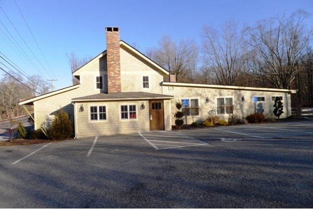
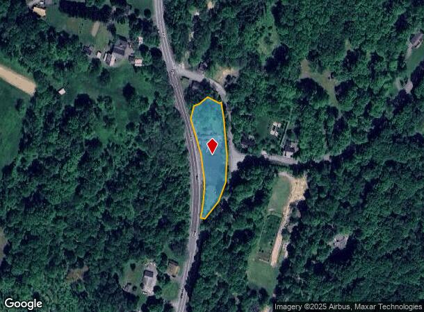
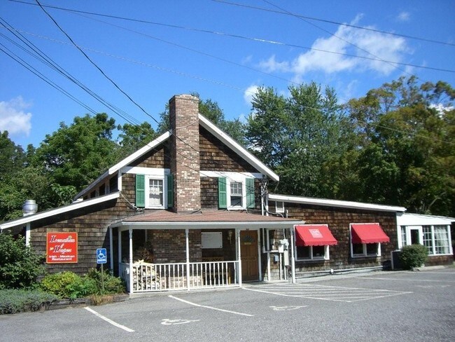
Property Record
7100 Albany Post Rd, Rhinebeck, NY 12572

NEARBY LISTINGS FOR SALE OR LEASE
Property Detail
7100 Albany Post Rd
134889-6271-00-223830-0000
1.2 AC 1893 0054 1650 0353
Restaurantbuilding
Dutchess
X
New York
36027C0132E
223
2025
1.10 AC
2024
Fishkill
150005
Westchester/So Connecticut
5,959 SF
Dutchess County-Putnam County, NY
DEMOGRAPHICS near 7100 Albany Post Rd
1 Mile
3 Mile
5 Mile
2024 Total Population
945
8,412
17,910
2029 Population
965
8,476
18,022
Pop Growth 2024-2029
+ 2.12%
+ 0.76%
+ 0.63%
Average Age
45
46
47
2024 Total Households
368
3,471
7,437
HH Growth 2024-2029
+ 2.17%
+ 0.72%
+ 0.61%
Median Household Inc
$91,598
$95,155
$97,102
Avg Household Size
2.40
2.30
2.20
2024 Avg HH Vehicles
2.00
2.00
2.00
Median Home Value
$345,394
$389,598
$407,222
Median Year Built
1972
1971
1971
Nearby Places
- Restaurants
- Banks
- Shops
- Fitness
- Groceries
SALE & LEASE HISTORY
LISTING DATE
SALE/LEASE

Sep 23, 2016
For Sale
Oct 12, 2016
For Sale
May 09, 2017
For Sale
Jul 10, 2018
For Sale
Nearby Properties
Address
Land Use
TOTAL SIZE
Lot Size
Zoning
Address
Land Use
TOTAL SIZE
Lot Size
Zoning
313,959 SF
9.59 AC
R1000
Address
Land Use
TOTAL SIZE
Lot Size
Zoning
71,318 SF
96.98 AC
R1000
Address
Land Use
TOTAL SIZE
Lot Size
Zoning
10 AC
R-20
Address
Land Use
TOTAL SIZE
Lot Size
Zoning
52,587 SF
122.50 AC
RC5
Address
Land Use
TOTAL SIZE
Lot Size
Zoning
48,731 SF
6.01 AC
Address
Land Use
TOTAL SIZE
Lot Size
Zoning
50,180 SF
14.18 AC
TND-CC
Address
Land Use
TOTAL SIZE
Lot Size
Zoning
32,610 SF
9.75 AC
RC5
Address
Land Use
TOTAL SIZE
Lot Size
Zoning
67,514 SF
10.50 AC
RC5
Address
Land Use
TOTAL SIZE
Lot Size
Zoning
1,875 SF
5.73 AC
R1.5
Address
Land Use
TOTAL SIZE
Lot Size
Zoning
2.55 AC
NMU
Address
Land Use
TOTAL SIZE
Lot Size
Zoning
27,360 SF
2.42 AC
NMU
Address
Land Use
TOTAL SIZE
Lot Size
Zoning
36,810 SF
6.67 AC
ORP
Address
Land Use
TOTAL SIZE
Lot Size
Zoning
860.90 AC
RA10
Address
Land Use
TOTAL SIZE
Lot Size
Zoning
10,421 SF
15.10 AC
RC5
Address
Land Use
TOTAL SIZE
Lot Size
Zoning
12,074 SF
45.41 AC
HP20
Address
Land Use
TOTAL SIZE
Lot Size
Zoning
16.58 AC
R-20
Address
Land Use
TOTAL SIZE
Lot Size
Zoning
11,580 SF
4.09 AC
M
Address
Land Use
TOTAL SIZE
Lot Size
Zoning
25,672 SF
3 AC
R10
Address
Land Use
TOTAL SIZE
Lot Size
Zoning
50,829 SF
3 AC
CBN
Address
Land Use
TOTAL SIZE
Lot Size
Zoning
3,200 SF
142.47 AC
ABD
Address
Land Use
TOTAL SIZE
Lot Size
Zoning
29,977 SF
1.82 AC
R10
Address
Land Use
TOTAL SIZE
Lot Size
Zoning
22,463 SF
7.90 AC
RC5
Address
Land Use
TOTAL SIZE
Lot Size
Zoning
21,627 SF
3 AC
GB
Address
Land Use
TOTAL SIZE
Lot Size
Zoning
28,505 SF
6.82 AC
RC5
Address
Land Use
TOTAL SIZE
Lot Size
Zoning
11,688 SF
10.02 AC
RC5
Address
Land Use
TOTAL SIZE
Lot Size
Zoning
12,422 SF
40.48 AC
RC5
Address
Land Use
TOTAL SIZE
Lot Size
Zoning
14,549 SF
1.10 AC
GB
Address
Land Use
TOTAL SIZE
Lot Size
Zoning
5,377 SF
11.14 AC
R-10
Address
Land Use
TOTAL SIZE
Lot Size
Zoning
15,120 SF
3.21 AC
CBN
Address
Land Use
TOTAL SIZE
Lot Size
Zoning
36,941 SF
13.29 AC
TND-CC
The World's #1 Commercial Real Estate Marketplace
Connect with us
© 2025 CoStar Group
The information above has been obtained from sources believed reliable. While we do not doubt its accuracy we have not verified it and make no guarantee, warranty or representation about it. It is your responsibility to independently confirm its accuracy and completeness. Any projections, opinions, assumptions, or estimates used are for example only and do not represent the current or future performance of the property. The value of this transaction to you depends on tax and other factors which should be evaluated by your tax, financial, and legal advisors. You and your advisors should conduct a careful, independent investigation of the property to determine to your satisfaction the suitability of the property for your needs.