Property Record
7100 E Highway 50 E, Mark Twain, NV 89403
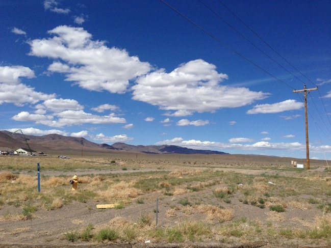
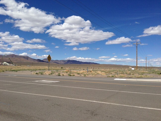

Property Detail
7100 E Highway 50 E
016-021-34
NOTE ON CREATION OF PAR, ZONE
Commercialacreage
LYON
C2
Nevada
B and X Area of moderate flood hazard, usually the area between the limits of the 100-year and 500-year floods.
5.56 AC
2026
Lyon County
2025
Reno/Sparks
960304
Reno, NV
NEARBY LISTINGS FOR SALE OR LEASE
DEMOGRAPHICS near 7100 E Highway 50 E
1 mile
3 mile
5 mile
2025 Total Population
1,089
7,938
9,692
2030 Population
1,170
8,423
10,260
Pop Growth 2025-2030
+ 7.44%
+ 6.11%
+ 5.86%
Average Age
43
44
45
2025 Total Households
408
3,001
3,713
HH Growth 2025-2030
+ 7.60%
+ 6.10%
+ 5.84%
Median Household Inc
$84,444
$92,644
$91,071
Avg Household Size
2.60
2.60
2.60
2025 Avg HH Vehicles
3.00
3.00
3.00
Median Home Value
$400,476
$421,859
$431,440
Median Year Built
2007
2003
2003
Nearby Places
Map Layers
Map Styles
 Street
 Aerial
Transit
 Traffic
 Biking
Places
Listings with unknown addresses are not visible on the map
- Restaurants
- Banks
- Shops
- Fitness
- Groceries
PUBLIC TRANSPORTATION
AIRPORT
Reno/Tahoe International
Drive
Walk
Distance
Reno/Tahoe International
53 min
31.7 mi
SALE & LEASE HISTORY
LISTING DATE
SALE/LEASE

Nov 15, 2018
For Sale
Nearby Properties
Address
Land Use
TOTAL SIZE
Lot Size
Zoning
Address
Land Use
TOTAL SIZE
Lot Size
Zoning
50,495 SF
10.76 AC
E1
Address
Land Use
TOTAL SIZE
Lot Size
Zoning
24.60 AC
MULT
Address
Land Use
TOTAL SIZE
Lot Size
Zoning
9,600 SF
4.50 AC
C2
Address
Land Use
TOTAL SIZE
Lot Size
Zoning
4,644 SF
1.18 AC
C2
Address
Land Use
TOTAL SIZE
Lot Size
Zoning
1,620 SF
2.81 AC
C2
Address
Land Use
TOTAL SIZE
Lot Size
Zoning
78.88 AC
E1
Address
Land Use
TOTAL SIZE
Lot Size
Zoning
2,400 SF
3.01 AC
C2
Address
Land Use
TOTAL SIZE
Lot Size
Zoning
7,771 SF
1.21 AC
C2
Address
Land Use
TOTAL SIZE
Lot Size
Zoning
67.47 AC
E1
Address
Land Use
TOTAL SIZE
Lot Size
Zoning
2,301 SF
4.98 AC
C2
Address
Land Use
TOTAL SIZE
Lot Size
Zoning
10,800 SF
2.73 AC
C2
Address
Land Use
TOTAL SIZE
Lot Size
Zoning
5,880 SF
2.70 AC
C2
Address
Land Use
TOTAL SIZE
Lot Size
Zoning
4,000 SF
3.59 AC
C1
Address
Land Use
TOTAL SIZE
Lot Size
Zoning
0.51 AC
RR2T
Address
Land Use
TOTAL SIZE
Lot Size
Zoning
5,715 SF
1.02 AC
C1
Address
Land Use
TOTAL SIZE
Lot Size
Zoning
3,264 SF
300 AC
I-2;INDUST
Address
Land Use
TOTAL SIZE
Lot Size
Zoning
1,953 SF
0.27 AC
E1
Address
Land Use
TOTAL SIZE
Lot Size
Zoning
34.76 AC
E1
Address
Land Use
TOTAL SIZE
Lot Size
Zoning
11,800 SF
3.42 AC
ME
Address
Land Use
TOTAL SIZE
Lot Size
Zoning
6,600 SF
2.75 AC
C2
Address
Land Use
TOTAL SIZE
Lot Size
Zoning
2,204 SF
0.32 AC
E1
Address
Land Use
TOTAL SIZE
Lot Size
Zoning
53.02 AC
SR-2
Address
Land Use
TOTAL SIZE
Lot Size
Zoning
4,800 SF
1.51 AC
C2
Address
Land Use
TOTAL SIZE
Lot Size
Zoning
1,529 SF
0.31 AC
E1
Address
Land Use
TOTAL SIZE
Lot Size
Zoning
1,529 SF
0.28 AC
E1
Address
Land Use
TOTAL SIZE
Lot Size
Zoning
1,270 SF
1,357.13 AC
MULT
Address
Land Use
TOTAL SIZE
Lot Size
Zoning
0.31 AC
SR-12000
Address
Land Use
TOTAL SIZE
Lot Size
Zoning
14.02 AC
C2
Address
Land Use
TOTAL SIZE
Lot Size
Zoning
960 SF
11.95 AC
PUD
The World's #1 Commercial Real Estate Marketplace
Connect with us
© 2026 CoStar Group
The information above has been obtained from sources believed reliable. While we do not doubt its accuracy we have not verified it and make no guarantee, warranty or representation about it. It is your responsibility to independently confirm its accuracy and completeness. Any projections, opinions, assumptions, or estimates used are for example only and do not represent the current or future performance of the property. The value of this transaction to you depends on tax and other factors which should be evaluated by your tax, financial, and legal advisors. You and your advisors should conduct a careful, independent investigation of the property to determine to your satisfaction the suitability of the property for your needs.