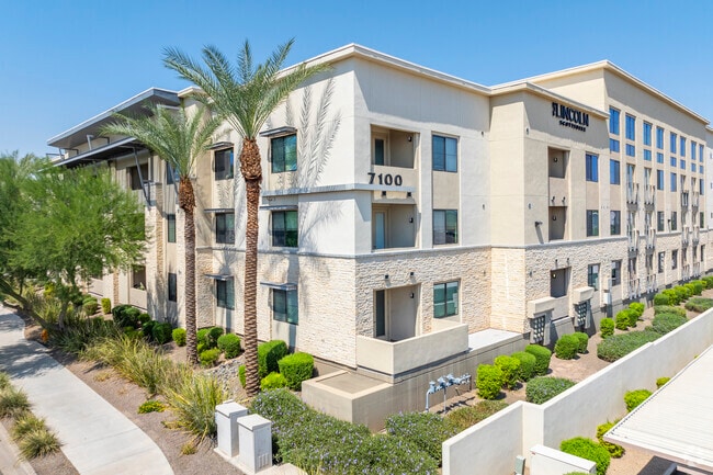
Property Record
7100 E Lincoln Dr, Paradise Valley, AZ 85253


Save to a Folder
{{folder.Name}}
{{folder.ListingIds.length}} Properties
{{folder.ListingIds.length}} Property
Create a New Folder
Property Detail
7100 E Lincoln Dr
174-57-006
BROADSTONE LINCOLN LOT 1 MCR 1222-09
Apartment
Maricopa
PUD
Arizona
B and X Area of moderate flood hazard, usually the area between the limits of the 100-year and 500-year floods.
1
2025
5.31 AC
2025
Paradise Valley
216901
Phoenix
358,139 SF
Phoenix-Mesa-Chandler, AZ
NEARBY LISTINGS FOR SALE OR LEASE
DEMOGRAPHICS near 7100 E Lincoln Dr
1 mile
3 mile
5 mile
2025 Total Population
6,536
70,802
188,659
2030 Population
6,964
75,207
198,964
Pop Growth 2025-2030
+ 6.55%
+ 6.22%
+ 5.46%
Average Age
51
46
44
2025 Total Households
3,485
36,195
90,733
HH Growth 2025-2030
+ 6.51%
+ 6.43%
+ 5.66%
Median Household Inc
$114,052
$107,712
$103,803
Avg Household Size
1.80
1.90
2.00
2025 Avg HH Vehicles
2.00
2.00
2.00
Median Home Value
$917,286
$808,217
$800,524
Median Year Built
1986
1981
1980
Nearby Places
Map Layers
Map Styles
 Street
 Aerial
Layers
 Traffic
 Biking
Places
Listings with unknown addresses are not visible on the map
- Restaurants
- Banks
- Shops
- Fitness
- Groceries
PUBLIC TRANSPORTATION
AIRPORT
Phoenix Sky Harbor International
Drive
Walk
Distance
Phoenix Sky Harbor International
21 min
11.3 mi
Phoenix-Mesa Gateway
Drive
Walk
Distance
Phoenix-Mesa Gateway
44 min
30.9 mi
Freight Ports
Port of San Diego
Drive
Walk
Distance
Port of San Diego
415 min
367.9 mi
Nearby Properties
Address
Land Use
TOTAL SIZE
Lot Size
Zoning
Address
Land Use
TOTAL SIZE
Lot Size
Zoning
Address
Land Use
TOTAL SIZE
Lot Size
Zoning
2,636,740 SF
21.88 AC
C-DT
Address
Land Use
TOTAL SIZE
Lot Size
Zoning
33,483 SF
7.82 AC
PF
Address
Land Use
TOTAL SIZE
Lot Size
Zoning
1,457,213 SF
41.78 AC
PUD
Address
Land Use
TOTAL SIZE
Lot Size
Zoning
981,325 SF
8.31 AC
Address
Land Use
TOTAL SIZE
Lot Size
Zoning
623,263 SF
27.34 AC
M-H
Address
Land Use
TOTAL SIZE
Lot Size
Zoning
440,573 SF
19.10 AC
SUPR
Address
Land Use
TOTAL SIZE
Lot Size
Zoning
1,229,384 SF
4.81 AC
Address
Land Use
TOTAL SIZE
Lot Size
Zoning
517,502 SF
21.26 AC
SUPR
Address
Land Use
TOTAL SIZE
Lot Size
Zoning
457,979 SF
9.26 AC
CO
Address
Land Use
TOTAL SIZE
Lot Size
Zoning
734,506 SF
7.75 AC
C-T
Address
Land Use
TOTAL SIZE
Lot Size
Zoning
268,262 SF
1.15 AC
C-DT
Address
Land Use
TOTAL SIZE
Lot Size
Zoning
439,600 SF
8.52 AC
DDCC2
Address
Land Use
TOTAL SIZE
Lot Size
Zoning
22,630 SF
1.06 AC
SUPP
Address
Land Use
TOTAL SIZE
Lot Size
Zoning
515,127 SF
7.57 AC
C-T
Address
Land Use
TOTAL SIZE
Lot Size
Zoning
289,633 SF
9.11 AC
R-10
Address
Land Use
TOTAL SIZE
Lot Size
Zoning
530,384 SF
5.24 AC
C-DT
Address
Land Use
TOTAL SIZE
Lot Size
Zoning
Address
Land Use
TOTAL SIZE
Lot Size
Zoning
590,903 SF
9.41 AC
C-DT
Address
Land Use
TOTAL SIZE
Lot Size
Zoning
245,175 SF
6.94 AC
DDRU2
Address
Land Use
TOTAL SIZE
Lot Size
Zoning
1,137 SF
76.71 AC
RE35
Address
Land Use
TOTAL SIZE
Lot Size
Zoning
153,890 SF
8.54 AC
C-R
Address
Land Use
TOTAL SIZE
Lot Size
Zoning
355,399 SF
7.13 AC
C-C
Address
Land Use
TOTAL SIZE
Lot Size
Zoning
153,300 SF
8.78 AC
R5
Address
Land Use
TOTAL SIZE
Lot Size
Zoning
121,740 SF
22.13 AC
SUPR
Address
Land Use
TOTAL SIZE
Lot Size
Zoning
158,895 SF
6.83 AC
R-43
Address
Land Use
TOTAL SIZE
Lot Size
Zoning
345,713 SF
18.25 AC
M-H
Address
Land Use
TOTAL SIZE
Lot Size
Zoning
138,984 SF
14.30 AC
C-C
Address
Land Use
TOTAL SIZE
Lot Size
Zoning
341,324 SF
1.93 AC
Address
Land Use
TOTAL SIZE
Lot Size
Zoning
195,343 SF
0.86 AC
DDMU2
The World's #1 Commercial Real Estate Marketplace
Connect with us
© 2026 CoStar Group
The information above has been obtained from sources believed reliable. While we do not doubt its accuracy we have not verified it and make no guarantee, warranty or representation about it. It is your responsibility to independently confirm its accuracy and completeness. Any projections, opinions, assumptions, or estimates used are for example only and do not represent the current or future performance of the property. The value of this transaction to you depends on tax and other factors which should be evaluated by your tax, financial, and legal advisors. You and your advisors should conduct a careful, independent investigation of the property to determine to your satisfaction the suitability of the property for your needs.