Property Record
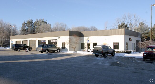
7100 Fulton St E, Ada, MI 49301

Property Detail
7100 Fulton St E
41-15-28-477-047
411528477047 PART OF SE 1/4 COM 655.59 FT S 88D 11M 03S W ALONG S SEC LINE & 142.04 FT N 1D 48M 57S W FROM SE COR OF SEC TH N
Commercialnec
KENT
C2
Michigan
B and X Area of moderate flood hazard, usually the area between the limits of the 100-year and 500-year floods.
3.26 AC
2024
Ada/Lowell
2025
West Michigan
011902
Grand Rapids-Wyoming-Kentwood, MI
15,056 SF
NEARBY LISTINGS FOR SALE OR LEASE
-
-
View all Ada listings for sale on LoopNet.com
DEMOGRAPHICS near 7100 Fulton St E
1 mile
3 mile
5 mile
2025 Total Population
2,259
19,691
54,425
2030 Population
2,354
20,379
56,032
Pop Growth 2025-2030
+ 4.21%
+ 3.49%
+ 2.95%
Average Age
40
41
41
2025 Total Households
756
6,837
19,385
HH Growth 2025-2030
+ 4.37%
+ 3.57%
+ 3.07%
Median Household Inc
$184,035
$156,123
$123,639
Avg Household Size
3.00
2.90
2.70
2025 Avg HH Vehicles
2.00
2.00
2.00
Median Home Value
$430,973
$498,557
$464,979
Median Year Built
1988
1992
1988
Nearby Places
Map Layers
Map Styles
 Street
 Aerial
Layers
 Traffic
 Biking
Places
Listings with unknown addresses are not visible on the map
- Restaurants
- Banks
- Shops
- Fitness
- Groceries
PUBLIC TRANSPORTATION
AIRPORT
Gerald R Ford International
Drive
Walk
Distance
Gerald R Ford International
23 min
12.1 mi
Freight Ports
Port Milwaukee
Drive
Walk
Distance
Port Milwaukee
317 min
272.6 mi
Nearby Properties
Address
Land Use
TOTAL SIZE
Lot Size
Zoning
Address
Land Use
TOTAL SIZE
Lot Size
Zoning
277.36 AC
I
Address
Land Use
TOTAL SIZE
Lot Size
Zoning
709,488 SF
106.95 AC
LI
Address
Land Use
TOTAL SIZE
Lot Size
Zoning
Address
Land Use
TOTAL SIZE
Lot Size
Zoning
226,877 SF
22.40 AC
R2
Address
Land Use
TOTAL SIZE
Lot Size
Zoning
8.97 AC
Address
Land Use
TOTAL SIZE
Lot Size
Zoning
Address
Land Use
TOTAL SIZE
Lot Size
Zoning
Address
Land Use
TOTAL SIZE
Lot Size
Zoning
33,540 SF
5.67 AC
PO
Address
Land Use
TOTAL SIZE
Lot Size
Zoning
14,700 SF
1.44 AC
Address
Land Use
TOTAL SIZE
Lot Size
Zoning
0.65 AC
Address
Land Use
TOTAL SIZE
Lot Size
Zoning
Address
Land Use
TOTAL SIZE
Lot Size
Zoning
64,790 SF
290,921.90 AC
PUD
Address
Land Use
TOTAL SIZE
Lot Size
Zoning
29,224 SF
5.48 AC
I
Address
Land Use
TOTAL SIZE
Lot Size
Zoning
0.20 AC
Address
Land Use
TOTAL SIZE
Lot Size
Zoning
44,215 SF
12.51 AC
PUD
Address
Land Use
TOTAL SIZE
Lot Size
Zoning
4,600 SF
0.64 AC
Address
Land Use
TOTAL SIZE
Lot Size
Zoning
39,312 SF
7.01 AC
R2
Address
Land Use
TOTAL SIZE
Lot Size
Zoning
79,921 SF
420,750 AC
PUD
Address
Land Use
TOTAL SIZE
Lot Size
Zoning
0.92 AC
C1
Address
Land Use
TOTAL SIZE
Lot Size
Zoning
18,096 SF
2.53 AC
PO
Address
Land Use
TOTAL SIZE
Lot Size
Zoning
87,210 SF
4 AC
I
Address
Land Use
TOTAL SIZE
Lot Size
Zoning
34,276 SF
6.40 AC
PO
Address
Land Use
TOTAL SIZE
Lot Size
Zoning
9,414 SF
1.64 AC
Address
Land Use
TOTAL SIZE
Lot Size
Zoning
22,848 SF
0.28 AC
Address
Land Use
TOTAL SIZE
Lot Size
Zoning
14,026 SF
2.57 AC
R3
Address
Land Use
TOTAL SIZE
Lot Size
Zoning
19,610 SF
R1
Address
Land Use
TOTAL SIZE
Lot Size
Zoning
0.44 AC
Address
Land Use
TOTAL SIZE
Lot Size
Zoning
0.17 AC
Address
Land Use
TOTAL SIZE
Lot Size
Zoning
1.24 AC
Address
Land Use
TOTAL SIZE
Lot Size
Zoning
45,872 SF
4.53 AC
I
The World's #1 Commercial Real Estate Marketplace
Connect with us
© 2026 CoStar Group
The information above has been obtained from sources believed reliable. While we do not doubt its accuracy we have not verified it and make no guarantee, warranty or representation about it. It is your responsibility to independently confirm its accuracy and completeness. Any projections, opinions, assumptions, or estimates used are for example only and do not represent the current or future performance of the property. The value of this transaction to you depends on tax and other factors which should be evaluated by your tax, financial, and legal advisors. You and your advisors should conduct a careful, independent investigation of the property to determine to your satisfaction the suitability of the property for your needs.