Property Record
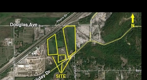
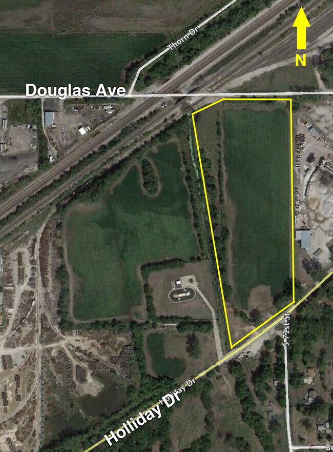
7112 Holliday Dr, Kansas City, KS 66106
This Property Is For Sale
NEARBY LISTINGS FOR SALE OR LEASE
Property Detail
7112 Holliday Dr
Kansas City, MO-KS
Hart Farm
225617
HART FARM B1-3, S33, T11, R24, ACRES 8.160000, B3 L2
Miscellaneous
Wyandotte
X
Kansas
20209C0153D
2
0
8.12 AC
2024
Kansas City KS
043700
Kansas City
DEMOGRAPHICS near 7112 Holliday Dr
1 Mile
3 Mile
5 Mile
2024 Total Population
647
28,428
108,415
2029 Population
635
28,304
108,648
Pop Growth 2024-2029
(1.85%)
(0.44%)
+ 0.21%
Average Age
43
41
39
2024 Total Households
255
10,773
43,035
HH Growth 2024-2029
(1.96%)
(0.38%)
+ 0.49%
Median Household Inc
$83,189
$75,464
$66,199
Avg Household Size
2.50
2.60
2.40
2024 Avg HH Vehicles
2.00
2.00
2.00
Median Home Value
$253,571
$224,612
$199,821
Median Year Built
1970
1971
1971
Nearby Places
Map Layers
Map Styles
 Street
 Aerial
- Restaurants
- Banks
- Shops
- Fitness
- Groceries
PUBLIC TRANSPORTATION
AIRPORT
Kansas City International
DRIVE
WALK
Distance
Kansas City International
31 min
26.0 mi
Nearby Properties
Address
Land Use
TOTAL SIZE
Lot Size
Zoning
Address
Land Use
TOTAL SIZE
Lot Size
Zoning
920,306 SF
90.21 AC
Address
Land Use
TOTAL SIZE
Lot Size
Zoning
872,064 SF
119.39 AC
Address
Land Use
TOTAL SIZE
Lot Size
Zoning
249,363 SF
58.59 AC
Address
Land Use
TOTAL SIZE
Lot Size
Zoning
100,090 SF
48.47 AC
KR1
Address
Land Use
TOTAL SIZE
Lot Size
Zoning
81,361 SF
3.81 AC
AG
Address
Land Use
TOTAL SIZE
Lot Size
Zoning
62,452 SF
14.89 AC
KR1
Address
Land Use
TOTAL SIZE
Lot Size
Zoning
80,474 SF
11.30 AC
R-1
Address
Land Use
TOTAL SIZE
Lot Size
Zoning
285,041 SF
109.90 AC
EI1
Address
Land Use
TOTAL SIZE
Lot Size
Zoning
77,375 SF
9.22 AC
R-1
Address
Land Use
TOTAL SIZE
Lot Size
Zoning
59,256 SF
22.06 AC
KR1
Address
Land Use
TOTAL SIZE
Lot Size
Zoning
13,925 SF
107.85 AC
KR1
Address
Land Use
TOTAL SIZE
Lot Size
Zoning
35,296 SF
4.16 AC
R-1
Address
Land Use
TOTAL SIZE
Lot Size
Zoning
33,609 SF
14.33 AC
R-1
Address
Land Use
TOTAL SIZE
Lot Size
Zoning
164,462 SF
23.15 AC
Address
Land Use
TOTAL SIZE
Lot Size
Zoning
53,352 SF
13.79 AC
KR1
Address
Land Use
TOTAL SIZE
Lot Size
Zoning
167,713 SF
78.95 AC
KR1
Address
Land Use
TOTAL SIZE
Lot Size
Zoning
15,264 SF
73.01 AC
KR1
Address
Land Use
TOTAL SIZE
Lot Size
Zoning
50,006 SF
18.98 AC
KR1
Address
Land Use
TOTAL SIZE
Lot Size
Zoning
180,000 SF
12.47 AC
Address
Land Use
TOTAL SIZE
Lot Size
Zoning
37,244 SF
9.08 AC
KR1
Address
Land Use
TOTAL SIZE
Lot Size
Zoning
175,620 SF
15.52 AC
Address
Land Use
TOTAL SIZE
Lot Size
Zoning
181,708 SF
20.29 AC
KR1
Address
Land Use
TOTAL SIZE
Lot Size
Zoning
27,022 SF
11.66 AC
K99
Address
Land Use
TOTAL SIZE
Lot Size
Zoning
2.80 AC
R-1
Address
Land Use
TOTAL SIZE
Lot Size
Zoning
14,700 SF
1.75 AC
Address
Land Use
TOTAL SIZE
Lot Size
Zoning
108,717 SF
14.50 AC
Address
Land Use
TOTAL SIZE
Lot Size
Zoning
13,673 SF
4.81 AC
Address
Land Use
TOTAL SIZE
Lot Size
Zoning
20,230 SF
32.30 AC
KR1
Address
Land Use
TOTAL SIZE
Lot Size
Zoning
17,722 SF
1.24 AC
R-1
Address
Land Use
TOTAL SIZE
Lot Size
Zoning
6,400 SF
71.31 AC
KR1
The World's #1 Commercial Real Estate Marketplace
Connect with us
© 2025 CoStar Group
The information above has been obtained from sources believed reliable. While we do not doubt its accuracy we have not verified it and make no guarantee, warranty or representation about it. It is your responsibility to independently confirm its accuracy and completeness. Any projections, opinions, assumptions, or estimates used are for example only and do not represent the current or future performance of the property. The value of this transaction to you depends on tax and other factors which should be evaluated by your tax, financial, and legal advisors. You and your advisors should conduct a careful, independent investigation of the property to determine to your satisfaction the suitability of the property for your needs.