Property Record
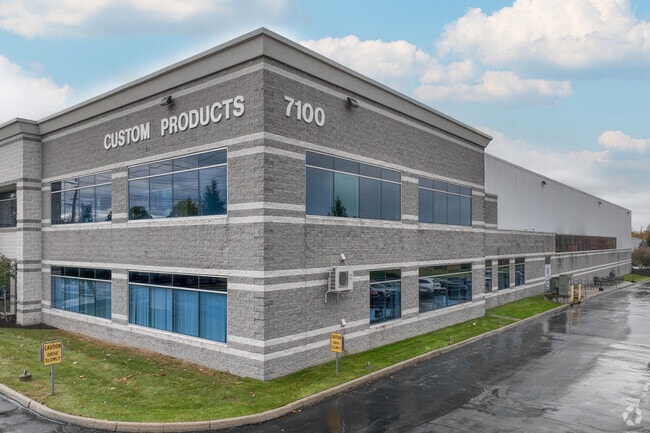
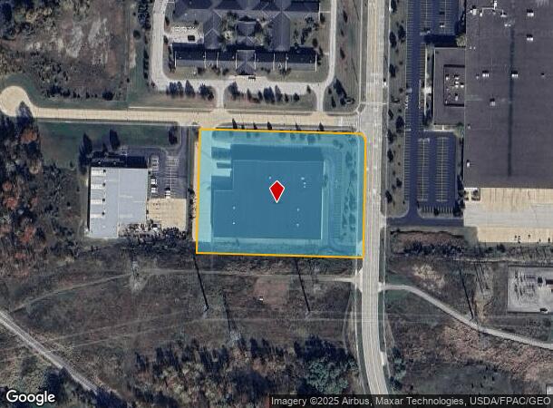
7100 Tinkers Ct, Solon, OH 44139

NEARBY LISTINGS FOR SALE OR LEASE
Property Detail
7100 Tinkers Ct
Cleveland-Elyria, OH
Solon 03
991-17-005
19 00B1
Publicstorage
Cuyahoga
X
Ohio
39153C0051F
b1
2024
5 AC
2024
Solon
184106
Cleveland
81,557 SF
DEMOGRAPHICS near 7100 Tinkers Ct
1 Mile
3 Mile
5 Mile
2024 Total Population
1,300
39,759
105,237
2029 Population
1,274
38,924
103,126
Pop Growth 2024-2029
(2.00%)
(2.10%)
(2.01%)
Average Age
45
43
43
2024 Total Households
433
16,017
43,592
HH Growth 2024-2029
(2.08%)
(2.20%)
(2.09%)
Median Household Inc
$92,307
$82,623
$77,823
Avg Household Size
2.60
2.40
2.40
2024 Avg HH Vehicles
2.00
2.00
2.00
Median Home Value
$297,663
$241,242
$248,697
Median Year Built
1985
1975
1975
Nearby Places
Map Layers
Map Styles
 Street
 Aerial
- Restaurants
- Banks
- Shops
- Fitness
- Groceries
PUBLIC TRANSPORTATION
COMMUTER RAIL
Canal Exploration Center (National Park Scenic Railway - Cuyahoga Valley Scenic Railroad)
DRIVE
WALK
Distance
Canal Exploration Center (National Park Scenic Railway - Cuyahoga Valley Scenic Railroad)
20 min
9.0 mi
AIRPORT
Cleveland-Hopkins International
DRIVE
WALK
Distance
Cleveland-Hopkins International
40 min
24.1 mi
Freight Ports
Port of Toledo
DRIVE
WALK
Distance
Port of Toledo
154 min
125.0 mi
Nearby Properties
Address
Land Use
TOTAL SIZE
Lot Size
Zoning
Address
Land Use
TOTAL SIZE
Lot Size
Zoning
130,621 SF
67.21 AC
I-2
Address
Land Use
TOTAL SIZE
Lot Size
Zoning
49.31 AC
Address
Land Use
TOTAL SIZE
Lot Size
Zoning
433,283 SF
29.89 AC
Address
Land Use
TOTAL SIZE
Lot Size
Zoning
90.68 AC
I-2
Address
Land Use
TOTAL SIZE
Lot Size
Zoning
433,283 SF
40.49 AC
Address
Land Use
TOTAL SIZE
Lot Size
Zoning
475,568 SF
38.17 AC
IG
Address
Land Use
TOTAL SIZE
Lot Size
Zoning
197,000 SF
42.41 AC
I-2
Address
Land Use
TOTAL SIZE
Lot Size
Zoning
246,138 SF
67.82 AC
R-1-C
Address
Land Use
TOTAL SIZE
Lot Size
Zoning
344,806 SF
35.19 AC
R-1-A
Address
Land Use
TOTAL SIZE
Lot Size
Zoning
396,420 SF
26.02 AC
IG
Address
Land Use
TOTAL SIZE
Lot Size
Zoning
401,401 SF
25.14 AC
IG
Address
Land Use
TOTAL SIZE
Lot Size
Zoning
184,512 SF
5.22 AC
C-1
Address
Land Use
TOTAL SIZE
Lot Size
Zoning
351,000 SF
25.48 AC
IG
Address
Land Use
TOTAL SIZE
Lot Size
Zoning
458,000 SF
35.06 AC
IG
Address
Land Use
TOTAL SIZE
Lot Size
Zoning
243,040 SF
9.36 AC
R-3-B
Address
Land Use
TOTAL SIZE
Lot Size
Zoning
49,264 SF
13.36 AC
C-3
Address
Land Use
TOTAL SIZE
Lot Size
Zoning
302,022 SF
19.04 AC
I-2
Address
Land Use
TOTAL SIZE
Lot Size
Zoning
147,635 SF
15.14 AC
I-2
Address
Land Use
TOTAL SIZE
Lot Size
Zoning
342,068 SF
29.02 AC
Address
Land Use
TOTAL SIZE
Lot Size
Zoning
262,950 SF
26.24 AC
IG
Address
Land Use
TOTAL SIZE
Lot Size
Zoning
594,909 SF
39.82 AC
I-2
Address
Land Use
TOTAL SIZE
Lot Size
Zoning
20.49 AC
R-1-C
Address
Land Use
TOTAL SIZE
Lot Size
Zoning
37.51 AC
I-2
Address
Land Use
TOTAL SIZE
Lot Size
Zoning
351,911 SF
39.85 AC
I-2
Address
Land Use
TOTAL SIZE
Lot Size
Zoning
90,287 SF
66.28 AC
G-2
Address
Land Use
TOTAL SIZE
Lot Size
Zoning
14.67 AC
I-2
Address
Land Use
TOTAL SIZE
Lot Size
Zoning
201,034 SF
21.07 AC
I-2
Address
Land Use
TOTAL SIZE
Lot Size
Zoning
268,672 SF
25.07 AC
R-3
Address
Land Use
TOTAL SIZE
Lot Size
Zoning
66,157 SF
13.08 AC
Address
Land Use
TOTAL SIZE
Lot Size
Zoning
197,930 SF
14.80 AC
I-2
The World's #1 Commercial Real Estate Marketplace
Connect with us
© 2025 CoStar Group
The information above has been obtained from sources believed reliable. While we do not doubt its accuracy we have not verified it and make no guarantee, warranty or representation about it. It is your responsibility to independently confirm its accuracy and completeness. Any projections, opinions, assumptions, or estimates used are for example only and do not represent the current or future performance of the property. The value of this transaction to you depends on tax and other factors which should be evaluated by your tax, financial, and legal advisors. You and your advisors should conduct a careful, independent investigation of the property to determine to your satisfaction the suitability of the property for your needs.