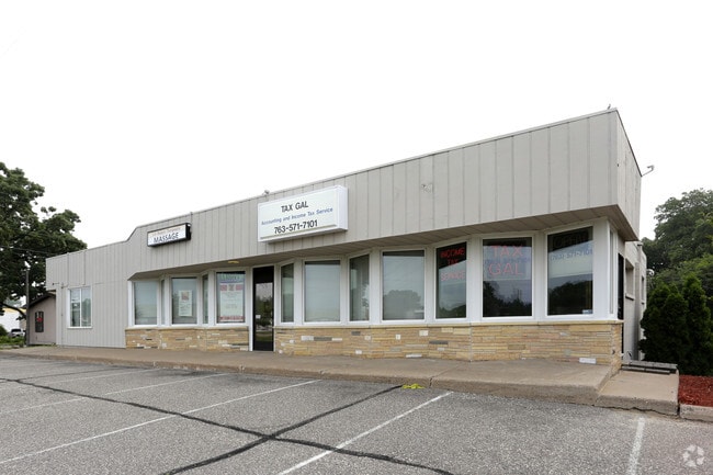
Property Record
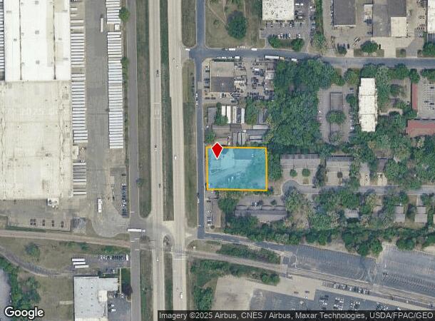
7101 Highway 65 Ne, Minneapolis, MN 55432
Current Lease Availabilities
NEARBY LISTINGS FOR SALE OR LEASE
Property Detail
7101 Highway 65 Ne
Minneapolis-St. Paul-Bloomington, MN-WI
Auditors Subdivision No 89
12-30-24-31-0012
THE W 270 FT OF LOT 4 AUD SUB NO 89, SUBJ TO EASE OF REC
Commercialnec
Anoka
X
Minnesota
27053C0250F
4
2025
1 AC
2025
North Central
051103
Minneapolis/St Paul
5,274 SF
DEMOGRAPHICS near 7101 Highway 65 Ne
1 Mile
3 Mile
5 Mile
2024 Total Population
10,064
81,385
222,613
2029 Population
10,404
82,152
223,762
Pop Growth 2024-2029
+ 3.38%
+ 0.94%
+ 0.52%
Average Age
39
40
39
2024 Total Households
3,662
31,458
84,141
HH Growth 2024-2029
+ 3.41%
+ 0.99%
+ 0.56%
Median Household Inc
$73,943
$74,382
$75,210
Avg Household Size
2.70
2.50
2.60
2024 Avg HH Vehicles
2.00
2.00
2.00
Median Home Value
$259,005
$265,201
$261,678
Median Year Built
1968
1970
1973
Nearby Places
- Restaurants
- Banks
- Shops
- Fitness
- Groceries
PUBLIC TRANSPORTATION
COMMUTER RAIL
Fridley Station (Northstar Corridor - Northstar Commuter Rail)
DRIVE
WALK
Distance
Fridley Station (Northstar Corridor - Northstar Commuter Rail)
7 min
3.4 mi
AIRPORT
Minneapolis-St Paul International/Wold-Chamberlain
DRIVE
WALK
Distance
Minneapolis-St Paul International/Wold-Chamberlain
36 min
22.9 mi
Freight Ports
Port Milwaukee
DRIVE
WALK
Distance
Port Milwaukee
381 min
345.7 mi
Nearby Properties
Address
Land Use
TOTAL SIZE
Lot Size
Zoning
Address
Land Use
TOTAL SIZE
Lot Size
Zoning
2,443,869 SF
31.79 AC
Address
Land Use
TOTAL SIZE
Lot Size
Zoning
47,727 SF
17.03 AC
Address
Land Use
TOTAL SIZE
Lot Size
Zoning
35,488 SF
39.07 AC
Address
Land Use
TOTAL SIZE
Lot Size
Zoning
Address
Land Use
TOTAL SIZE
Lot Size
Zoning
663,908 SF
109.91 AC
Address
Land Use
TOTAL SIZE
Lot Size
Zoning
417,810 SF
20.60 AC
Address
Land Use
TOTAL SIZE
Lot Size
Zoning
33,060 SF
20.14 AC
Address
Land Use
TOTAL SIZE
Lot Size
Zoning
66,342 SF
8.85 AC
Address
Land Use
TOTAL SIZE
Lot Size
Zoning
264,574 SF
12.71 AC
Address
Land Use
TOTAL SIZE
Lot Size
Zoning
229,420 SF
4.14 AC
Address
Land Use
TOTAL SIZE
Lot Size
Zoning
539,671 SF
26.93 AC
Address
Land Use
TOTAL SIZE
Lot Size
Zoning
249,884 SF
Address
Land Use
TOTAL SIZE
Lot Size
Zoning
334,568 SF
30.27 AC
Address
Land Use
TOTAL SIZE
Lot Size
Zoning
393,252 SF
40 AC
Address
Land Use
TOTAL SIZE
Lot Size
Zoning
27,175 SF
1.86 AC
Address
Land Use
TOTAL SIZE
Lot Size
Zoning
13,588 SF
129.03 AC
Address
Land Use
TOTAL SIZE
Lot Size
Zoning
Address
Land Use
TOTAL SIZE
Lot Size
Zoning
Address
Land Use
TOTAL SIZE
Lot Size
Zoning
12.37 AC
Address
Land Use
TOTAL SIZE
Lot Size
Zoning
213,984 SF
12.21 AC
Address
Land Use
TOTAL SIZE
Lot Size
Zoning
208 SF
228 AC
Address
Land Use
TOTAL SIZE
Lot Size
Zoning
194,221 SF
27.83 AC
Address
Land Use
TOTAL SIZE
Lot Size
Zoning
14,908 SF
28.38 AC
Address
Land Use
TOTAL SIZE
Lot Size
Zoning
186,928 SF
4.07 AC
Address
Land Use
TOTAL SIZE
Lot Size
Zoning
196 SF
9.81 AC
Address
Land Use
TOTAL SIZE
Lot Size
Zoning
169,628 SF
2.67 AC
Address
Land Use
TOTAL SIZE
Lot Size
Zoning
212,161 SF
35.98 AC
Address
Land Use
TOTAL SIZE
Lot Size
Zoning
10.28 AC
Address
Land Use
TOTAL SIZE
Lot Size
Zoning
368,545 SF
18.09 AC
Address
Land Use
TOTAL SIZE
Lot Size
Zoning
398,544 SF
17.52 AC
The World's #1 Commercial Real Estate Marketplace
Connect with us
© 2025 CoStar Group
The information above has been obtained from sources believed reliable. While we do not doubt its accuracy we have not verified it and make no guarantee, warranty or representation about it. It is your responsibility to independently confirm its accuracy and completeness. Any projections, opinions, assumptions, or estimates used are for example only and do not represent the current or future performance of the property. The value of this transaction to you depends on tax and other factors which should be evaluated by your tax, financial, and legal advisors. You and your advisors should conduct a careful, independent investigation of the property to determine to your satisfaction the suitability of the property for your needs.