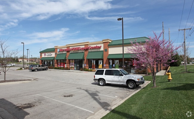
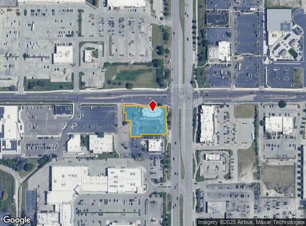
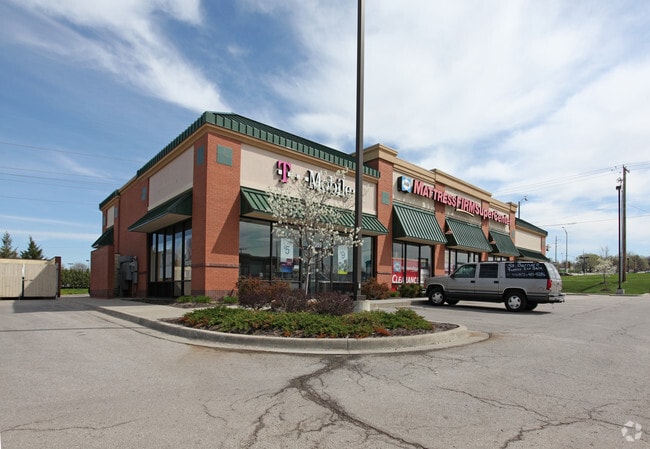
Property Record
9100 Metcalf Ave, Overland Park, KS 66212
Current Lease Availabilities
NEARBY LISTINGS FOR SALE OR LEASE
Property Detail
9100 Metcalf Ave
Kansas City, MO-KS
Replat Of North Regency Park
NP53460000-0004
REPLAT OF NORTH REGENCY PARK LT 4 OPC 692 10 4
Regionalshoppingcenterormallwithanchorstore
Johnson
X
Kansas
20091C0053G
4
2024
0.92 AC
2024
Northeast Johnson County
051803
Kansas City
7,500 SF
DEMOGRAPHICS near 9100 Metcalf Ave
1 Mile
3 Mile
5 Mile
2024 Total Population
12,934
99,000
260,944
2029 Population
13,489
103,326
270,249
Pop Growth 2024-2029
+ 4.29%
+ 4.37%
+ 3.57%
Average Age
41
41
41
2024 Total Households
5,996
43,859
116,668
HH Growth 2024-2029
+ 4.62%
+ 4.59%
+ 3.68%
Median Household Inc
$68,525
$78,764
$82,600
Avg Household Size
2.10
2.20
2.20
2024 Avg HH Vehicles
2.00
2.00
2.00
Median Home Value
$270,435
$296,695
$302,098
Median Year Built
1965
1967
1972
Nearby Places
- Restaurants
- Banks
- Shops
- Fitness
- Groceries
PUBLIC TRANSPORTATION
AIRPORT
Kansas City International
DRIVE
WALK
Distance
Kansas City International
41 min
29.7 mi
Nearby Properties
Address
Land Use
TOTAL SIZE
Lot Size
Zoning
Address
Land Use
TOTAL SIZE
Lot Size
Zoning
857,568 SF
38.48 AC
PUD-G
Address
Land Use
TOTAL SIZE
Lot Size
Zoning
203,079 SF
8.10 AC
BP2
Address
Land Use
TOTAL SIZE
Lot Size
Zoning
177,588 SF
9.27 AC
CP-O
Address
Land Use
TOTAL SIZE
Lot Size
Zoning
189,882 SF
13.04 AC
CP-O
Address
Land Use
TOTAL SIZE
Lot Size
Zoning
183,684 SF
36.94 AC
R-1A
Address
Land Use
TOTAL SIZE
Lot Size
Zoning
188,248 SF
4.78 AC
C-2
Address
Land Use
TOTAL SIZE
Lot Size
Zoning
122,309 SF
76.14 AC
R-1
Address
Land Use
TOTAL SIZE
Lot Size
Zoning
234,968 SF
37.40 AC
R-1
Address
Land Use
TOTAL SIZE
Lot Size
Zoning
133,505 SF
16.41 AC
R-1
Address
Land Use
TOTAL SIZE
Lot Size
Zoning
120,305 SF
7.01 AC
CP-O
Address
Land Use
TOTAL SIZE
Lot Size
Zoning
166,039 SF
35.38 AC
R-1
Address
Land Use
TOTAL SIZE
Lot Size
Zoning
81,051 SF
7.17 AC
R-1
Address
Land Use
TOTAL SIZE
Lot Size
Zoning
110,710 SF
4.66 AC
CP-O
Address
Land Use
TOTAL SIZE
Lot Size
Zoning
81,762 SF
9.66 AC
R-1
Address
Land Use
TOTAL SIZE
Lot Size
Zoning
146,143 SF
10.59 AC
CP-2
Address
Land Use
TOTAL SIZE
Lot Size
Zoning
113,263 SF
3.53 AC
CP-O
Address
Land Use
TOTAL SIZE
Lot Size
Zoning
73,383 SF
9.53 AC
R-1
Address
Land Use
TOTAL SIZE
Lot Size
Zoning
411,435 SF
17.41 AC
CP-2
Address
Land Use
TOTAL SIZE
Lot Size
Zoning
79,437 SF
4.12 AC
DFD
Address
Land Use
TOTAL SIZE
Lot Size
Zoning
73,793 SF
9.21 AC
R-1A
Address
Land Use
TOTAL SIZE
Lot Size
Zoning
69,958 SF
10.93 AC
R-1
Address
Land Use
TOTAL SIZE
Lot Size
Zoning
85,703 SF
7.84 AC
R-1
Address
Land Use
TOTAL SIZE
Lot Size
Zoning
355,197 SF
30.05 AC
CP-2
Address
Land Use
TOTAL SIZE
Lot Size
Zoning
179,965 SF
6.15 AC
CP-O
Address
Land Use
TOTAL SIZE
Lot Size
Zoning
120,225 SF
9.13 AC
R-1
Address
Land Use
TOTAL SIZE
Lot Size
Zoning
89,002 SF
8.77 AC
R-1
Address
Land Use
TOTAL SIZE
Lot Size
Zoning
119,320 SF
19.74 AC
R-1
Address
Land Use
TOTAL SIZE
Lot Size
Zoning
79,737 SF
11.90 AC
R-1
Address
Land Use
TOTAL SIZE
Lot Size
Zoning
77,548 SF
7.21 AC
R-1
Address
Land Use
TOTAL SIZE
Lot Size
Zoning
37,499 SF
3.72 AC
PUD-G
The World's #1 Commercial Real Estate Marketplace
Connect with us
© 2025 CoStar Group
The information above has been obtained from sources believed reliable. While we do not doubt its accuracy we have not verified it and make no guarantee, warranty or representation about it. It is your responsibility to independently confirm its accuracy and completeness. Any projections, opinions, assumptions, or estimates used are for example only and do not represent the current or future performance of the property. The value of this transaction to you depends on tax and other factors which should be evaluated by your tax, financial, and legal advisors. You and your advisors should conduct a careful, independent investigation of the property to determine to your satisfaction the suitability of the property for your needs.