Property Record
7101 8Th Ave, Jenison, MI 49428
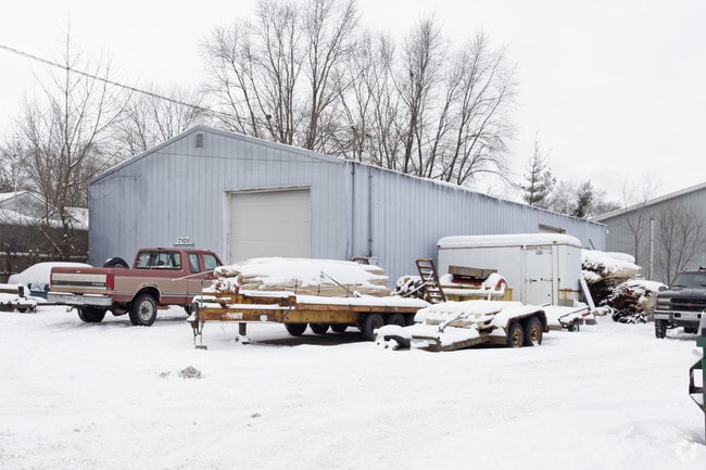

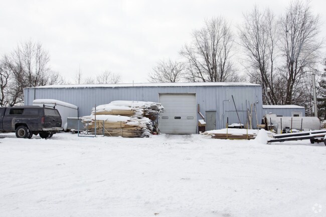
Property Detail
7101 8Th Ave
70-14-23-250-028
LOT 3 R H LOWINGS SUPR PLAT
Autorepair
Ottawa
HS
Michigan
B and X Area of moderate flood hazard, usually the area between the limits of the 100-year and 500-year floods.
3
2025
0.28 AC
2025
E Ottawa Cnty/Hudsonville
021502
West Michigan
3,320 SF
Grand Rapids-Wyoming-Kentwood, MI
NEARBY LISTINGS FOR SALE OR LEASE
-
-
View all Jenison listings for sale on LoopNet.com
DEMOGRAPHICS near 7101 8Th Ave
1 mile
3 mile
5 mile
2025 Total Population
7,125
50,974
122,471
2030 Population
7,276
52,128
125,954
Pop Growth 2025-2030
+ 2.12%
+ 2.26%
+ 2.84%
Average Age
42
40
39
2025 Total Households
3,014
19,417
45,515
HH Growth 2025-2030
+ 2.32%
+ 2.43%
+ 2.94%
Median Household Inc
$74,102
$85,508
$87,763
Avg Household Size
2.30
2.60
2.60
2025 Avg HH Vehicles
2.00
2.00
2.00
Median Home Value
$255,355
$297,766
$305,128
Median Year Built
1973
1978
1983
Nearby Places
Map Layers
Map Styles
 Street
 Aerial
Layers
 Traffic
 Biking
Places
Listings with unknown addresses are not visible on the map
- Restaurants
- Banks
- Shops
- Fitness
- Groceries
PUBLIC TRANSPORTATION
COMMUTER RAIL
Drive
Walk
Distance
13 min
8.7 mi
AIRPORT
Gerald R Ford International
Drive
Walk
Distance
Gerald R Ford International
31 min
17.0 mi
Nearby Properties
Address
Land Use
TOTAL SIZE
Lot Size
Zoning
Address
Land Use
TOTAL SIZE
Lot Size
Zoning
79.40 AC
C-4
Address
Land Use
TOTAL SIZE
Lot Size
Zoning
12.64 AC
PUD
Address
Land Use
TOTAL SIZE
Lot Size
Zoning
268,440 SF
28.11 AC
HDR
Address
Land Use
TOTAL SIZE
Lot Size
Zoning
225,992 SF
14.40 AC
Address
Land Use
TOTAL SIZE
Lot Size
Zoning
20.61 AC
HDR
Address
Land Use
TOTAL SIZE
Lot Size
Zoning
230,864 SF
59.58 AC
PUD2
Address
Land Use
TOTAL SIZE
Lot Size
Zoning
269,021 SF
22.89 AC
HDR
Address
Land Use
TOTAL SIZE
Lot Size
Zoning
173,288 SF
4.17 AC
PUD
Address
Land Use
TOTAL SIZE
Lot Size
Zoning
211,138 SF
30.58 AC
C-5
Address
Land Use
TOTAL SIZE
Lot Size
Zoning
222,785 SF
26.69 AC
CS
Address
Land Use
TOTAL SIZE
Lot Size
Zoning
124,950 SF
18.30 AC
MHR
Address
Land Use
TOTAL SIZE
Lot Size
Zoning
14.69 AC
R3-B
Address
Land Use
TOTAL SIZE
Lot Size
Zoning
89,648 SF
3.17 AC
OS-2
Address
Land Use
TOTAL SIZE
Lot Size
Zoning
9.65 AC
R3-B
Address
Land Use
TOTAL SIZE
Lot Size
Zoning
139,774 SF
10.67 AC
HDR-B
Address
Land Use
TOTAL SIZE
Lot Size
Zoning
9 AC
R3-A
Address
Land Use
TOTAL SIZE
Lot Size
Zoning
60,523 SF
6.48 AC
C-1
Address
Land Use
TOTAL SIZE
Lot Size
Zoning
82,554 SF
5.56 AC
HDR
Address
Land Use
TOTAL SIZE
Lot Size
Zoning
136,766 SF
18.52 AC
B3
Address
Land Use
TOTAL SIZE
Lot Size
Zoning
164,700 SF
19.18 AC
C-5
Address
Land Use
TOTAL SIZE
Lot Size
Zoning
60,980 SF
2.51 AC
PUD
Address
Land Use
TOTAL SIZE
Lot Size
Zoning
135,752 SF
13.86 AC
C-5
Address
Land Use
TOTAL SIZE
Lot Size
Zoning
62,080 SF
2.54 AC
PUD
Address
Land Use
TOTAL SIZE
Lot Size
Zoning
6.77 AC
R3-B
Address
Land Use
TOTAL SIZE
Lot Size
Zoning
71,102 SF
8.65 AC
MHR
Address
Land Use
TOTAL SIZE
Lot Size
Zoning
44,871 SF
3.35 AC
PUD
Address
Land Use
TOTAL SIZE
Lot Size
Zoning
45,636 SF
14.11 AC
C-5
Address
Land Use
TOTAL SIZE
Lot Size
Zoning
120,236 SF
13.33 AC
ER
Address
Land Use
TOTAL SIZE
Lot Size
Zoning
42,745 SF
8.74 AC
C-1
Address
Land Use
TOTAL SIZE
Lot Size
Zoning
106,193 SF
10.68 AC
CS
The World's #1 Commercial Real Estate Marketplace
Connect with us
© 2026 CoStar Group
The information above has been obtained from sources believed reliable. While we do not doubt its accuracy we have not verified it and make no guarantee, warranty or representation about it. It is your responsibility to independently confirm its accuracy and completeness. Any projections, opinions, assumptions, or estimates used are for example only and do not represent the current or future performance of the property. The value of this transaction to you depends on tax and other factors which should be evaluated by your tax, financial, and legal advisors. You and your advisors should conduct a careful, independent investigation of the property to determine to your satisfaction the suitability of the property for your needs.