Property Record
7102 Harrison Ave, Cincinnati, OH 45247
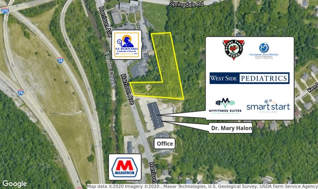
This Property Is For Sale
Property Detail
7102 Harrison Ave
Cincinnati, OH-KY-IN
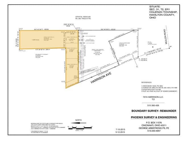
ES HARRISON PK 108.15 X 191.31 IRRPT LOT 6 CHAS JACOBS HEIRS SUB R1 T2 S31
510-0360-0061
Hamilton
Residentialacreage
Ohio
C and X Area of minimal flood hazard, usually depicted on FIRMs as above the 500-year flood level.
6
2025
0.36 AC
2025
Forest Park/West
020601
Cincinnati/Dayton
2,742 SF
NEARBY LISTINGS FOR SALE OR LEASE
DEMOGRAPHICS near 7102 Harrison Ave
1 mile
3 mile
5 mile
2025 Total Population
4,856
25,332
89,521
2030 Population
4,869
25,358
89,477
Pop Growth 2025-2030
+ 0.27%
+ 0.10%
(0.05%)
Average Age
42
42
42
2025 Total Households
1,997
10,232
35,874
HH Growth 2025-2030
+ 0.25%
+ 0.09%
(0.10%)
Median Household Inc
$93,023
$93,050
$85,325
Avg Household Size
2.40
2.40
2.40
2025 Avg HH Vehicles
2.00
2.00
2.00
Median Home Value
$297,161
$300,844
$254,917
Median Year Built
1996
1986
1975
Nearby Places
Map Layers
Map Styles
 Street
 Aerial
Layers
 Traffic
 Biking
Places
Listings with unknown addresses are not visible on the map
- Restaurants
- Banks
- Shops
- Fitness
- Groceries
PUBLIC TRANSPORTATION
AIRPORT
Cincinnati/Northern Kentucky International
Drive
Walk
Distance
Cincinnati/Northern Kentucky International
44 min
27.0 mi
Nearby Properties
Address
Land Use
TOTAL SIZE
Lot Size
Zoning
Address
Land Use
TOTAL SIZE
Lot Size
Zoning
5.38 AC
OO
Address
Land Use
TOTAL SIZE
Lot Size
Zoning
12.23 AC
Address
Land Use
TOTAL SIZE
Lot Size
Zoning
83.15 AC
Address
Land Use
TOTAL SIZE
Lot Size
Zoning
474 SF
9.59 AC
A
Address
Land Use
TOTAL SIZE
Lot Size
Zoning
1,671 SF
21.48 AC
CCUP
Address
Land Use
TOTAL SIZE
Lot Size
Zoning
4.68 AC
E
Address
Land Use
TOTAL SIZE
Lot Size
Zoning
29,084 SF
30.10 AC
DD
Address
Land Use
TOTAL SIZE
Lot Size
Zoning
20.34 AC
Address
Land Use
TOTAL SIZE
Lot Size
Zoning
18.30 AC
EE
Address
Land Use
TOTAL SIZE
Lot Size
Zoning
8,580 SF
19.31 AC
DD
Address
Land Use
TOTAL SIZE
Lot Size
Zoning
Address
Land Use
TOTAL SIZE
Lot Size
Zoning
35,496 SF
13.86 AC
A
Address
Land Use
TOTAL SIZE
Lot Size
Zoning
8.69 AC
EE
Address
Land Use
TOTAL SIZE
Lot Size
Zoning
2.76 AC
EE
Address
Land Use
TOTAL SIZE
Lot Size
Zoning
19,608 SF
11.60 AC
Address
Land Use
TOTAL SIZE
Lot Size
Zoning
Address
Land Use
TOTAL SIZE
Lot Size
Zoning
4,439 SF
1,059.01 AC
AA
Address
Land Use
TOTAL SIZE
Lot Size
Zoning
Address
Land Use
TOTAL SIZE
Lot Size
Zoning
69.35 AC
Address
Land Use
TOTAL SIZE
Lot Size
Zoning
4.59 AC
EE
Address
Land Use
TOTAL SIZE
Lot Size
Zoning
1,208 SF
5.37 AC
EE
Address
Land Use
TOTAL SIZE
Lot Size
Zoning
21.29 AC
Address
Land Use
TOTAL SIZE
Lot Size
Zoning
Address
Land Use
TOTAL SIZE
Lot Size
Zoning
4.14 AC
EE
Address
Land Use
TOTAL SIZE
Lot Size
Zoning
19,119 SF
5.28 AC
E
Address
Land Use
TOTAL SIZE
Lot Size
Zoning
1,692 SF
0.89 AC
EE
Address
Land Use
TOTAL SIZE
Lot Size
Zoning
Address
Land Use
TOTAL SIZE
Lot Size
Zoning
1.12 AC
EE
Address
Land Use
TOTAL SIZE
Lot Size
Zoning
8,468 SF
2.76 AC
OPUD
Address
Land Use
TOTAL SIZE
Lot Size
Zoning
5,282 SF
17.72 AC
The World's #1 Commercial Real Estate Marketplace
Connect with us
© 2026 CoStar Group
The information above has been obtained from sources believed reliable. While we do not doubt its accuracy we have not verified it and make no guarantee, warranty or representation about it. It is your responsibility to independently confirm its accuracy and completeness. Any projections, opinions, assumptions, or estimates used are for example only and do not represent the current or future performance of the property. The value of this transaction to you depends on tax and other factors which should be evaluated by your tax, financial, and legal advisors. You and your advisors should conduct a careful, independent investigation of the property to determine to your satisfaction the suitability of the property for your needs.