Property Record
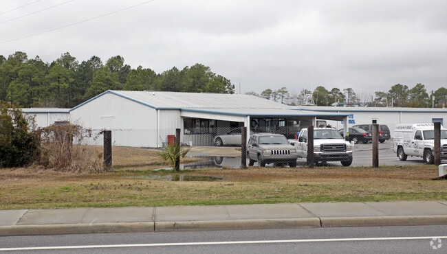
7103 Highway 77, Panama City, FL 32409


NEARBY LISTINGS FOR SALE OR LEASE
-
-
View all Panama City listings for sale on LoopNet.com
Property Detail
7103 Highway 77
08026-030-000
St Andrew Bay Pecan & Fig Grvs
Warehouse
27 2S 14W -106.25- 101A3 COM AT THE SE COR OF SEC TH W ALONG S LINE OF SEC 3984.74 TO THE NEW WLY R/W OF HWY 77 FOR POB TH W 306.82 N 357.03 TO THE SLY R/W OF GRASSY POINT RD TH N48 DEG E ALONG SAID R/W 517.69 S 63.73 W 25.39 TH S 547.23 TH S 64 DEG
AE
Bay
12005C0219J
Florida
2023
4.01 AC
2024
Panama City
000203
Other Market Areas
57,580 SF
Panama City, FL
DEMOGRAPHICS near 7103 Highway 77
1 Mile
3 Mile
5 Mile
2024 Total Population
1,256
10,470
30,532
2029 Population
1,348
11,013
31,948
Pop Growth 2024-2029
+ 7.32%
+ 5.19%
+ 4.64%
Average Age
40
42
40
2024 Total Households
470
3,925
11,537
HH Growth 2024-2029
+ 8.09%
+ 5.71%
+ 5.04%
Median Household Inc
$46,736
$63,180
$71,224
Avg Household Size
2.70
2.60
2.60
2024 Avg HH Vehicles
2.00
2.00
2.00
Median Home Value
$167,646
$247,456
$251,111
Median Year Built
1992
1990
1992
Nearby Places
Map Layers
Map Styles
 Street
 Aerial
- Restaurants
- Banks
- Shops
- Fitness
- Groceries
PUBLIC TRANSPORTATION
AIRPORT
Northwest Florida Beaches International
DRIVE
WALK
Distance
Northwest Florida Beaches International
21 min
14.0 mi
Freight Ports
Port of Panama City
DRIVE
WALK
Distance
Port of Panama City
23 min
10.7 mi
Nearby Properties
Address
Land Use
TOTAL SIZE
Lot Size
Zoning
Address
Land Use
TOTAL SIZE
Lot Size
Zoning
50,491 SF
6.48 AC
BC14
Address
Land Use
TOTAL SIZE
Lot Size
Zoning
241.76 AC
BC01
Address
Land Use
TOTAL SIZE
Lot Size
Zoning
453.24 AC
UND
Address
Land Use
TOTAL SIZE
Lot Size
Zoning
42,809 SF
0.77 AC
PSP
Address
Land Use
TOTAL SIZE
Lot Size
Zoning
27,485 SF
1.76 AC
BC16
Address
Land Use
TOTAL SIZE
Lot Size
Zoning
2,895 SF
97.83 AC
Address
Land Use
TOTAL SIZE
Lot Size
Zoning
69,020 SF
4.44 AC
BC14
Address
Land Use
TOTAL SIZE
Lot Size
Zoning
16,165 SF
1.72 AC
RB
Address
Land Use
TOTAL SIZE
Lot Size
Zoning
73,792 SF
7.53 AC
PSP
Address
Land Use
TOTAL SIZE
Lot Size
Zoning
24,134 SF
5.17 AC
UND
Address
Land Use
TOTAL SIZE
Lot Size
Zoning
6.65 AC
BC13
Address
Land Use
TOTAL SIZE
Lot Size
Zoning
5,472 SF
1.84 AC
RB
Address
Land Use
TOTAL SIZE
Lot Size
Zoning
231.05 AC
BC08
Address
Land Use
TOTAL SIZE
Lot Size
Zoning
31 AC
BC16
Address
Land Use
TOTAL SIZE
Lot Size
Zoning
40 AC
COM
Address
Land Use
TOTAL SIZE
Lot Size
Zoning
16,929 SF
4.06 AC
BC14
Address
Land Use
TOTAL SIZE
Lot Size
Zoning
24,484 SF
3.44 AC
PSP
Address
Land Use
TOTAL SIZE
Lot Size
Zoning
61 AC
COM
Address
Land Use
TOTAL SIZE
Lot Size
Zoning
12,060 SF
50.03 AC
BC14
Address
Land Use
TOTAL SIZE
Lot Size
Zoning
13,770 SF
2.07 AC
SB
Address
Land Use
TOTAL SIZE
Lot Size
Zoning
7,998 SF
3.05 AC
BC05
Address
Land Use
TOTAL SIZE
Lot Size
Zoning
110.28 AC
BC08
Address
Land Use
TOTAL SIZE
Lot Size
Zoning
5,490 SF
1.24 AC
A
Address
Land Use
TOTAL SIZE
Lot Size
Zoning
16,815 SF
5.48 AC
BC05
Address
Land Use
TOTAL SIZE
Lot Size
Zoning
6,812 SF
0.86 AC
R1
Address
Land Use
TOTAL SIZE
Lot Size
Zoning
975 SF
3.44 AC
PSP
Address
Land Use
TOTAL SIZE
Lot Size
Zoning
36.70 AC
BC08
Address
Land Use
TOTAL SIZE
Lot Size
Zoning
5,752 SF
1.18 AC
RB
Address
Land Use
TOTAL SIZE
Lot Size
Zoning
8,381 SF
0.87 AC
RB
The World's #1 Commercial Real Estate Marketplace
Connect with us
© 2025 CoStar Group
The information above has been obtained from sources believed reliable. While we do not doubt its accuracy we have not verified it and make no guarantee, warranty or representation about it. It is your responsibility to independently confirm its accuracy and completeness. Any projections, opinions, assumptions, or estimates used are for example only and do not represent the current or future performance of the property. The value of this transaction to you depends on tax and other factors which should be evaluated by your tax, financial, and legal advisors. You and your advisors should conduct a careful, independent investigation of the property to determine to your satisfaction the suitability of the property for your needs.