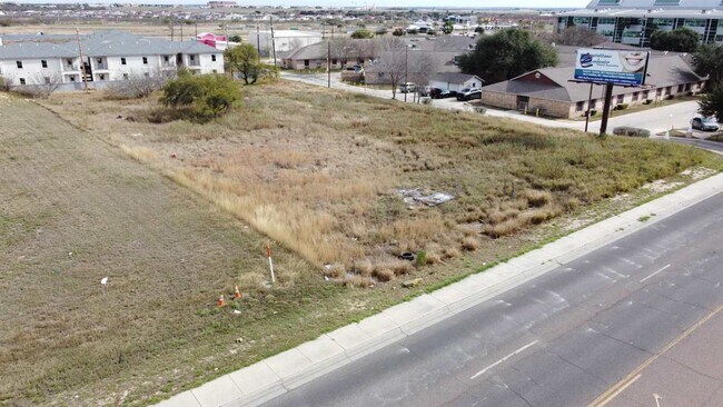
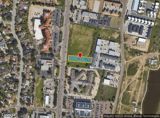
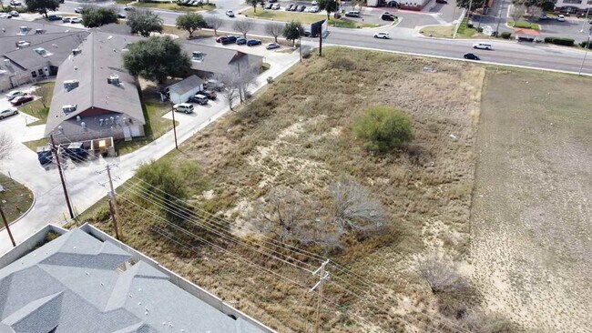
Property Record
7105 Mcpherson Rd, Laredo, TX 78041
NEARBY LISTINGS FOR SALE OR LEASE
Property Detail
7105 Mcpherson Rd
Laredo, TX
Buitron/Ramos
545351
BUITRON/RAMOS, BLOCK 1, LOT 1
Residentialacreage
Webb
X
Texas
48479C1205C
1
2024
0.53 AC
2025
Texas South Area
001719
Other Market Areas
DEMOGRAPHICS near 7105 Mcpherson Rd
1 Mile
3 Mile
5 Mile
2024 Total Population
11,247
84,807
172,335
2029 Population
11,401
85,883
173,830
Pop Growth 2024-2029
+ 1.37%
+ 1.27%
+ 0.87%
Average Age
38
36
35
2024 Total Households
3,864
27,358
53,830
HH Growth 2024-2029
+ 1.50%
+ 1.33%
+ 0.92%
Median Household Inc
$70,817
$68,117
$56,118
Avg Household Size
2.80
3.00
3.10
2024 Avg HH Vehicles
2.00
2.00
2.00
Median Home Value
$276,827
$218,617
$173,557
Median Year Built
1996
1997
1993
Nearby Places
Map Layers
Map Styles
 Street
 Aerial
- Restaurants
- Banks
- Shops
- Fitness
- Groceries
PUBLIC TRANSPORTATION
AIRPORT
Laredo International
DRIVE
WALK
Distance
Laredo International
10 min
3.9 mi
SALE & LEASE HISTORY
LISTING DATE
SALE/LEASE

Feb 04, 2021
For Sale
Nearby Properties
Address
Land Use
TOTAL SIZE
Lot Size
Zoning
Address
Land Use
TOTAL SIZE
Lot Size
Zoning
1,443,608 SF
116.27 AC
Address
Land Use
TOTAL SIZE
Lot Size
Zoning
668,900 SF
38.32 AC
B4
Address
Land Use
TOTAL SIZE
Lot Size
Zoning
497,463 SF
1.77 AC
R1
Address
Land Use
TOTAL SIZE
Lot Size
Zoning
178,000 SF
23.50 AC
B4
Address
Land Use
TOTAL SIZE
Lot Size
Zoning
489,093 SF
32.23 AC
B4
Address
Land Use
TOTAL SIZE
Lot Size
Zoning
251,512 SF
57.32 AC
B4
Address
Land Use
TOTAL SIZE
Lot Size
Zoning
337,607 SF
45.06 AC
R1
Address
Land Use
TOTAL SIZE
Lot Size
Zoning
255,819 SF
50 AC
R1
Address
Land Use
TOTAL SIZE
Lot Size
Zoning
152.08 AC
M1
Address
Land Use
TOTAL SIZE
Lot Size
Zoning
258,114 SF
30.54 AC
B1
Address
Land Use
TOTAL SIZE
Lot Size
Zoning
227,503 SF
19.84 AC
B4
Address
Land Use
TOTAL SIZE
Lot Size
Zoning
164,276 SF
43.92 AC
Address
Land Use
TOTAL SIZE
Lot Size
Zoning
192,176 SF
34.94 AC
Address
Land Use
TOTAL SIZE
Lot Size
Zoning
109,695 SF
3.73 AC
M1
Address
Land Use
TOTAL SIZE
Lot Size
Zoning
194,520 SF
11.18 AC
B3
Address
Land Use
TOTAL SIZE
Lot Size
Zoning
355,229 SF
15.41 AC
M1
Address
Land Use
TOTAL SIZE
Lot Size
Zoning
254,594 SF
11.84 AC
Address
Land Use
TOTAL SIZE
Lot Size
Zoning
192,203 SF
22.01 AC
B4
Address
Land Use
TOTAL SIZE
Lot Size
Zoning
218,415 SF
13.41 AC
R3
Address
Land Use
TOTAL SIZE
Lot Size
Zoning
203,922 SF
11 AC
R2
Address
Land Use
TOTAL SIZE
Lot Size
Zoning
122,752 SF
17.16 AC
R2
Address
Land Use
TOTAL SIZE
Lot Size
Zoning
170,632 SF
8.03 AC
B3
Address
Land Use
TOTAL SIZE
Lot Size
Zoning
144,522 SF
3.86 AC
B3
Address
Land Use
TOTAL SIZE
Lot Size
Zoning
158,728 SF
7.89 AC
Address
Land Use
TOTAL SIZE
Lot Size
Zoning
101,034 SF
19.79 AC
Address
Land Use
TOTAL SIZE
Lot Size
Zoning
50,765 SF
39.73 AC
Address
Land Use
TOTAL SIZE
Lot Size
Zoning
139,521 SF
18.13 AC
M1
Address
Land Use
TOTAL SIZE
Lot Size
Zoning
100,598 SF
26.22 AC
Address
Land Use
TOTAL SIZE
Lot Size
Zoning
66,567 SF
3.81 AC
M1
Address
Land Use
TOTAL SIZE
Lot Size
Zoning
10,712 SF
745.84 AC
AG
The World's #1 Commercial Real Estate Marketplace
Connect with us
© 2026 CoStar Group
The information above has been obtained from sources believed reliable. While we do not doubt its accuracy we have not verified it and make no guarantee, warranty or representation about it. It is your responsibility to independently confirm its accuracy and completeness. Any projections, opinions, assumptions, or estimates used are for example only and do not represent the current or future performance of the property. The value of this transaction to you depends on tax and other factors which should be evaluated by your tax, financial, and legal advisors. You and your advisors should conduct a careful, independent investigation of the property to determine to your satisfaction the suitability of the property for your needs.