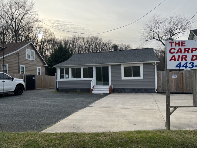
Property Record
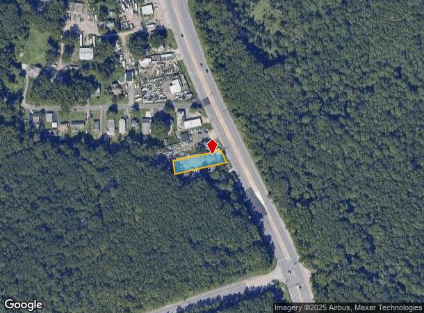
7108 Fort Smallwood Rd, Curtis Bay, MD 21226
NEARBY LISTINGS FOR SALE OR LEASE
Property Detail
7108 Fort Smallwood Rd
Baltimore-Columbia-Towson, MD
Felix A Valney Sub
03-000-14210000
LT C FELIX A VALNEY SUB
Officebuilding
Anne Arundel
X
Maryland
2400870036G
c
2024
0.34 AC
2025
Route 2 Corridor
730102
Baltimore
1,056 SF
DEMOGRAPHICS near 7108 Fort Smallwood Rd
1 Mile
3 Mile
5 Mile
2024 Total Population
2,577
31,130
153,962
2029 Population
2,710
31,954
156,568
Pop Growth 2024-2029
+ 5.16%
+ 2.65%
+ 1.69%
Average Age
35
39
39
2024 Total Households
973
11,899
57,260
HH Growth 2024-2029
+ 5.24%
+ 2.68%
+ 1.72%
Median Household Inc
$117,455
$103,634
$82,615
Avg Household Size
2.60
2.60
2.60
2024 Avg HH Vehicles
2.00
2.00
2.00
Median Home Value
$424,268
$343,327
$306,984
Median Year Built
2011
1988
1971
Nearby Places
Map Layers
Map Styles
 Street
 Aerial
- Restaurants
- Banks
- Shops
- Fitness
- Groceries
PUBLIC TRANSPORTATION
AIRPORT
Baltimore/Washington International Thurgood Marshall
DRIVE
WALK
Distance
Baltimore/Washington International Thurgood Marshall
20 min
12.0 mi
Ronald Reagan Washington Ntl
DRIVE
WALK
Distance
Ronald Reagan Washington Ntl
67 min
44.4 mi
Freight Ports
Port of Baltimore
DRIVE
WALK
Distance
Port of Baltimore
22 min
13.2 mi
SALE & LEASE HISTORY
LISTING DATE
SALE/LEASE

Jun 13, 2023
For Lease
Nearby Properties
Address
Land Use
TOTAL SIZE
Lot Size
Zoning
Address
Land Use
TOTAL SIZE
Lot Size
Zoning
1,186,080 SF
456.52 AC
W3
Address
Land Use
TOTAL SIZE
Lot Size
Zoning
467.03 AC
W2
Address
Land Use
TOTAL SIZE
Lot Size
Zoning
512,900 SF
51.15 AC
W1
Address
Land Use
TOTAL SIZE
Lot Size
Zoning
252,911 SF
8.32 AC
R10
Address
Land Use
TOTAL SIZE
Lot Size
Zoning
111.20 AC
W3
Address
Land Use
TOTAL SIZE
Lot Size
Zoning
340,000 SF
35 AC
W1
Address
Land Use
TOTAL SIZE
Lot Size
Zoning
239,476 SF
19.02 AC
MI
Address
Land Use
TOTAL SIZE
Lot Size
Zoning
291,600 SF
14.52 AC
W2
Address
Land Use
TOTAL SIZE
Lot Size
Zoning
304,404 SF
16.74 AC
W3
Address
Land Use
TOTAL SIZE
Lot Size
Zoning
119,220 SF
6.99 AC
W1
Address
Land Use
TOTAL SIZE
Lot Size
Zoning
345,088 SF
28.26 AC
W2
Address
Land Use
TOTAL SIZE
Lot Size
Zoning
351,620 SF
15.68 AC
W2
Address
Land Use
TOTAL SIZE
Lot Size
Zoning
227,704 SF
23.52 AC
C4
Address
Land Use
TOTAL SIZE
Lot Size
Zoning
674,828 SF
167.04 AC
W3
Address
Land Use
TOTAL SIZE
Lot Size
Zoning
344,254 SF
20.82 AC
W3
Address
Land Use
TOTAL SIZE
Lot Size
Zoning
155,608 SF
18.68 AC
C3
Address
Land Use
TOTAL SIZE
Lot Size
Zoning
482,600 SF
26.50 AC
I-2
Address
Land Use
TOTAL SIZE
Lot Size
Zoning
126,300 SF
18.81 AC
C3
Address
Land Use
TOTAL SIZE
Lot Size
Zoning
336,216 SF
19.99 AC
W1
Address
Land Use
TOTAL SIZE
Lot Size
Zoning
154,368 SF
17.01 AC
W3
Address
Land Use
TOTAL SIZE
Lot Size
Zoning
371,145 SF
17.41 AC
W1
Address
Land Use
TOTAL SIZE
Lot Size
Zoning
185,787 SF
12.60 AC
W3
Address
Land Use
TOTAL SIZE
Lot Size
Zoning
7.27 AC
R15
Address
Land Use
TOTAL SIZE
Lot Size
Zoning
267,551 SF
11.87 AC
W2
Address
Land Use
TOTAL SIZE
Lot Size
Zoning
133,454 SF
13.56 AC
C3
Address
Land Use
TOTAL SIZE
Lot Size
Zoning
190,168 SF
58.58 AC
MI
Address
Land Use
TOTAL SIZE
Lot Size
Zoning
300,700 SF
58.45 AC
W3
Address
Land Use
TOTAL SIZE
Lot Size
Zoning
4.33 AC
R15
Address
Land Use
TOTAL SIZE
Lot Size
Zoning
293,269 SF
14.67 AC
W1
Address
Land Use
TOTAL SIZE
Lot Size
Zoning
203,190 SF
16.76 AC
W3
The World's #1 Commercial Real Estate Marketplace
Connect with us
© 2025 CoStar Group
The information above has been obtained from sources believed reliable. While we do not doubt its accuracy we have not verified it and make no guarantee, warranty or representation about it. It is your responsibility to independently confirm its accuracy and completeness. Any projections, opinions, assumptions, or estimates used are for example only and do not represent the current or future performance of the property. The value of this transaction to you depends on tax and other factors which should be evaluated by your tax, financial, and legal advisors. You and your advisors should conduct a careful, independent investigation of the property to determine to your satisfaction the suitability of the property for your needs.