Property Record
711 E Cloud Ave, Andover, KS 67002
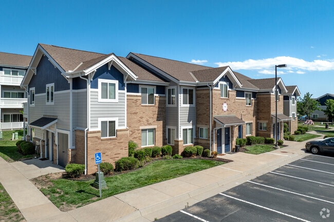


Property Detail
711 E Cloud Ave
Wichita, KS
MARKETPLACE COMMERCIAL 3RD ADD, S29, T27, R03E, BLOCK 2, LOT 1, ACRES 12.7
309-29-0-20-02-090-00-0
Butler
Apartmenthouse5plusunits
Kansas
B and X Area of moderate flood hazard, usually the area between the limits of the 100-year and 500-year floods.
1
0
12.70 AC
2025
Butler County
020210
Wichita
7,924 SF
NEARBY LISTINGS FOR SALE OR LEASE
-
-
View all Andover listings for sale on LoopNet.com
DEMOGRAPHICS near 711 E Cloud Ave
1 mile
3 mile
5 mile
2025 Total Population
3,981
20,189
45,914
2030 Population
4,046
20,606
47,160
Pop Growth 2025-2030
+ 1.63%
+ 2.07%
+ 2.71%
Average Age
36
40
40
2025 Total Households
1,483
7,020
16,078
HH Growth 2025-2030
+ 1.75%
+ 2.12%
+ 2.77%
Median Household Inc
$72,914
$110,208
$115,942
Avg Household Size
2.60
2.80
2.80
2025 Avg HH Vehicles
2.00
2.00
2.00
Median Home Value
$216,335
$329,952
$331,398
Median Year Built
1998
1997
2000
Nearby Places
Map Layers
Map Styles
 Street
 Aerial
Layers
 Traffic
 Biking
Places
Listings with unknown addresses are not visible on the map
- Restaurants
- Banks
- Shops
- Fitness
- Groceries
PUBLIC TRANSPORTATION
AIRPORT
Wichita Dwight D Eisenhower Ntl
Drive
Walk
Distance
Wichita Dwight D Eisenhower Ntl
26 min
18.3 mi
Freight Ports
Tulsa Port Of Catoosa
Drive
Walk
Distance
Tulsa Port Of Catoosa
213 min
200.8 mi
Nearby Properties
Address
Land Use
TOTAL SIZE
Lot Size
Zoning
Address
Land Use
TOTAL SIZE
Lot Size
Zoning
121.30 AC
Address
Land Use
TOTAL SIZE
Lot Size
Zoning
126.70 AC
Address
Land Use
TOTAL SIZE
Lot Size
Zoning
32.40 AC
Address
Land Use
TOTAL SIZE
Lot Size
Zoning
129,965 SF
39.35 AC
SF-5
Address
Land Use
TOTAL SIZE
Lot Size
Zoning
117,375 SF
20.60 AC
Address
Land Use
TOTAL SIZE
Lot Size
Zoning
123,253 SF
14.60 AC
Address
Land Use
TOTAL SIZE
Lot Size
Zoning
97,612 SF
28.40 AC
Address
Land Use
TOTAL SIZE
Lot Size
Zoning
16.80 AC
Address
Land Use
TOTAL SIZE
Lot Size
Zoning
15,597 SF
67.40 AC
Address
Land Use
TOTAL SIZE
Lot Size
Zoning
37,934 SF
24.82 AC
SF-5
Address
Land Use
TOTAL SIZE
Lot Size
Zoning
20.60 AC
Address
Land Use
TOTAL SIZE
Lot Size
Zoning
86,955 SF
Address
Land Use
TOTAL SIZE
Lot Size
Zoning
14,337 SF
3 AC
Address
Land Use
TOTAL SIZE
Lot Size
Zoning
47,234 SF
8.70 AC
Address
Land Use
TOTAL SIZE
Lot Size
Zoning
15,184 SF
136.70 AC
Address
Land Use
TOTAL SIZE
Lot Size
Zoning
38,759 SF
14.86 AC
SF-5
Address
Land Use
TOTAL SIZE
Lot Size
Zoning
20,113 SF
2.90 AC
Address
Land Use
TOTAL SIZE
Lot Size
Zoning
70,937 SF
9.60 AC
Address
Land Use
TOTAL SIZE
Lot Size
Zoning
199,945 SF
3.40 AC
Address
Land Use
TOTAL SIZE
Lot Size
Zoning
8,993 SF
1.70 AC
Address
Land Use
TOTAL SIZE
Lot Size
Zoning
20,744 SF
2.50 AC
Address
Land Use
TOTAL SIZE
Lot Size
Zoning
29,697 SF
6.34 AC
SF-5
Address
Land Use
TOTAL SIZE
Lot Size
Zoning
174,164 SF
18.50 AC
Address
Land Use
TOTAL SIZE
Lot Size
Zoning
3.50 AC
Address
Land Use
TOTAL SIZE
Lot Size
Zoning
17,048 SF
7.77 AC
SF-5
Address
Land Use
TOTAL SIZE
Lot Size
Zoning
16,172 SF
21.37 AC
SF-5
Address
Land Use
TOTAL SIZE
Lot Size
Zoning
9,839 SF
2.60 AC
Address
Land Use
TOTAL SIZE
Lot Size
Zoning
9.60 AC
Address
Land Use
TOTAL SIZE
Lot Size
Zoning
119,030 SF
12.40 AC
The World's #1 Commercial Real Estate Marketplace
Connect with us
© 2026 CoStar Group
The information above has been obtained from sources believed reliable. While we do not doubt its accuracy we have not verified it and make no guarantee, warranty or representation about it. It is your responsibility to independently confirm its accuracy and completeness. Any projections, opinions, assumptions, or estimates used are for example only and do not represent the current or future performance of the property. The value of this transaction to you depends on tax and other factors which should be evaluated by your tax, financial, and legal advisors. You and your advisors should conduct a careful, independent investigation of the property to determine to your satisfaction the suitability of the property for your needs.