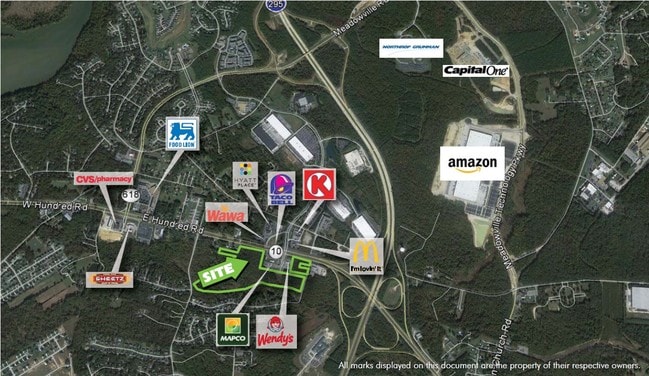
Property Record
711 E Hundred Rd, Chester, VA 23836
NEARBY LISTINGS FOR SALE OR LEASE
-
-
No Photo
-
-
-
-
View all Chester listings for sale on LoopNet.com
Property Detail
711 E Hundred Rd
Richmond, VA
Bermuda Ochre
818-65-14-25-900-000
S/L EAST HUNDRED ROAD
Commercialnec
Chesterfield
X
Virginia
51041C0351E
5.38 AC
2025
Iron Bridge Corridor
2025
Richmond VA
100509
DEMOGRAPHICS near 711 E Hundred Rd
1 Mile
3 Mile
5 Mile
2024 Total Population
4,189
19,030
57,504
2029 Population
4,578
20,919
60,819
Pop Growth 2024-2029
+ 9.29%
+ 9.93%
+ 5.76%
Average Age
38
40
39
2024 Total Households
1,504
6,857
20,286
HH Growth 2024-2029
+ 9.31%
+ 9.83%
+ 5.92%
Median Household Inc
$106,475
$96,116
$73,061
Avg Household Size
2.80
2.70
2.60
2024 Avg HH Vehicles
2.00
2.00
2.00
Median Home Value
$289,999
$323,658
$244,828
Median Year Built
1995
1994
1984
Nearby Places
Map Layers
Map Styles
 Street
 Aerial
- Restaurants
- Banks
- Shops
- Fitness
- Groceries
PUBLIC TRANSPORTATION
AIRPORT
Richmond International
DRIVE
WALK
Distance
Richmond International
25 min
17.8 mi
Freight Ports
Virginia Port Authority - Richmond
DRIVE
WALK
Distance
Virginia Port Authority - Richmond
21 min
13.2 mi
Nearby Properties
Address
Land Use
TOTAL SIZE
Lot Size
Zoning
Address
Land Use
TOTAL SIZE
Lot Size
Zoning
549.22 AC
A1
Address
Land Use
TOTAL SIZE
Lot Size
Zoning
107.29 AC
Address
Land Use
TOTAL SIZE
Lot Size
Zoning
99.30 AC
I2 - GEN I
Address
Land Use
TOTAL SIZE
Lot Size
Zoning
252,000 SF
118.66 AC
I3 - HVY I
Address
Land Use
TOTAL SIZE
Lot Size
Zoning
440,100 SF
82.70 AC
I2 - GEN I
Address
Land Use
TOTAL SIZE
Lot Size
Zoning
557,533 SF
48.60 AC
I2 - GEN I
Address
Land Use
TOTAL SIZE
Lot Size
Zoning
41,930 SF
23.04 AC
C5 - GEN B
Address
Land Use
TOTAL SIZE
Lot Size
Zoning
88,847 SF
93.02 AC
A - AGRICU
Address
Land Use
TOTAL SIZE
Lot Size
Zoning
49,595 SF
28.14 AC
I2 - GEN I
Address
Land Use
TOTAL SIZE
Lot Size
Zoning
352,800 SF
54.30 AC
I2 - GEN I
Address
Land Use
TOTAL SIZE
Lot Size
Zoning
81,138 SF
27.31 AC
C2 - NBHD
Address
Land Use
TOTAL SIZE
Lot Size
Zoning
100 SF
14.70 AC
C5 - GEN B
Address
Land Use
TOTAL SIZE
Lot Size
Zoning
404,200 SF
62.22 AC
I2 - GEN I
Address
Land Use
TOTAL SIZE
Lot Size
Zoning
296,000 SF
42.39 AC
I2 - GEN I
Address
Land Use
TOTAL SIZE
Lot Size
Zoning
241,800 SF
16.96 AC
I2 - GEN I
Address
Land Use
TOTAL SIZE
Lot Size
Zoning
242,042 SF
10.15 AC
I2 - GEN I
Address
Land Use
TOTAL SIZE
Lot Size
Zoning
91,105 SF
10.90 AC
C3 - COMMU
Address
Land Use
TOTAL SIZE
Lot Size
Zoning
340.76 AC
I2 - GEN I
Address
Land Use
TOTAL SIZE
Lot Size
Zoning
187,980 SF
15.31 AC
I1 - LT IN
Address
Land Use
TOTAL SIZE
Lot Size
Zoning
173,800 SF
15.99 AC
I2 - GEN I
Address
Land Use
TOTAL SIZE
Lot Size
Zoning
490,345 SF
101.57 AC
I2 - GEN I
Address
Land Use
TOTAL SIZE
Lot Size
Zoning
203,544 SF
15.17 AC
I1 - LT IN
Address
Land Use
TOTAL SIZE
Lot Size
Zoning
47.44 AC
MH1 - MOBI
Address
Land Use
TOTAL SIZE
Lot Size
Zoning
219 SF
74.95 AC
I3 - HVY I
Address
Land Use
TOTAL SIZE
Lot Size
Zoning
186,837 SF
26.82 AC
I2 - GEN I
Address
Land Use
TOTAL SIZE
Lot Size
Zoning
158,400 SF
9.96 AC
I1 - LT IN
Address
Land Use
TOTAL SIZE
Lot Size
Zoning
228,108 SF
19.32 AC
I1 - LT IN
Address
Land Use
TOTAL SIZE
Lot Size
Zoning
95,824 SF
2.29 AC
C3 - COMMU
Address
Land Use
TOTAL SIZE
Lot Size
Zoning
35,173 SF
19.30 AC
C3 - COMMU
Address
Land Use
TOTAL SIZE
Lot Size
Zoning
120 SF
100.80 AC
I3 - HVY I
The World's #1 Commercial Real Estate Marketplace
Connect with us
© 2025 CoStar Group
The information above has been obtained from sources believed reliable. While we do not doubt its accuracy we have not verified it and make no guarantee, warranty or representation about it. It is your responsibility to independently confirm its accuracy and completeness. Any projections, opinions, assumptions, or estimates used are for example only and do not represent the current or future performance of the property. The value of this transaction to you depends on tax and other factors which should be evaluated by your tax, financial, and legal advisors. You and your advisors should conduct a careful, independent investigation of the property to determine to your satisfaction the suitability of the property for your needs.