Property Record
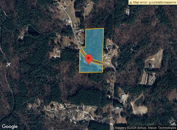
711 John Horton Rd, Apex, NC 27523

NEARBY LISTINGS FOR SALE OR LEASE
Property Detail
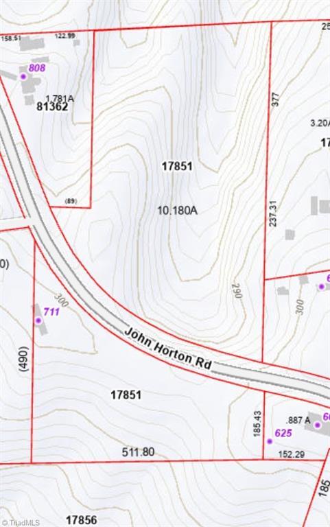
711 John Horton Rd
17851
South East New Hope
Vacantlandnec
TRACT B AC 10.18 BK 22 PG 30
X
Chatham
3720070200K
North Carolina
2025
10.18 AC
2025
Chatham County
020702
Raleigh/Durham
980 SF
Durham-Chapel Hill, NC
DEMOGRAPHICS near 711 John Horton Rd
1 mile
3 mile
5 mile
2024 Total Population
274
2,698
32,318
2029 Population
311
3,098
36,660
Pop Growth 2024-2029
+ 13.50%
+ 14.83%
+ 13.44%
Average Age
46
41
37
2024 Total Households
114
1,011
10,998
HH Growth 2024-2029
+ 13.16%
+ 14.64%
+ 13.48%
Median Household Inc
$95,454
$124,384
$153,882
Avg Household Size
2.30
2.60
2.90
2024 Avg HH Vehicles
3.00
2.00
2.00
Median Home Value
$648,936
$603,448
$618,014
Median Year Built
1992
2004
2010
Nearby Places
Map Layers
Map Styles
 Street
 Aerial
Transit
 Traffic
 Biking
Places
Listings with unknown addresses are not visible on the map
- Restaurants
- Banks
- Shops
- Fitness
- Groceries
PUBLIC TRANSPORTATION
AIRPORT
Raleigh-Durham International
Drive
Walk
Distance
Raleigh-Durham International
30 min
20.1 mi
Freight Ports
Port of Wilmington
Drive
Walk
Distance
Port of Wilmington
179 min
152.6 mi
SALE & LEASE HISTORY
LISTING DATE
SALE/LEASE

Nov 28, 2023
For Sale
Nearby Properties
Address
Land Use
TOTAL SIZE
Lot Size
Zoning
Address
Land Use
TOTAL SIZE
Lot Size
Zoning
1,704 SF
38,566.08 AC
R-5
Address
Land Use
TOTAL SIZE
Lot Size
Zoning
174,645 SF
23.23 AC
LI-CZ
Address
Land Use
TOTAL SIZE
Lot Size
Zoning
189,429 SF
26.61 AC
PUD-C
Address
Land Use
TOTAL SIZE
Lot Size
Zoning
178,880 SF
55.35 AC
LI-CZ
Address
Land Use
TOTAL SIZE
Lot Size
Zoning
22,534 SF
20.01 AC
CD-RB
Address
Land Use
TOTAL SIZE
Lot Size
Zoning
39,040 SF
42.75 AC
CD-IL
Address
Land Use
TOTAL SIZE
Lot Size
Zoning
83.23 AC
M-1
Address
Land Use
TOTAL SIZE
Lot Size
Zoning
28,089 SF
16.40 AC
R-80W
Address
Land Use
TOTAL SIZE
Lot Size
Zoning
45.06 AC
PUD-C
Address
Land Use
TOTAL SIZE
Lot Size
Zoning
4,432 SF
41.02 AC
PUD-C
Address
Land Use
TOTAL SIZE
Lot Size
Zoning
10,756 SF
28.30 AC
R-1
Address
Land Use
TOTAL SIZE
Lot Size
Zoning
3,670 SF
58.97 AC
M-1
Address
Land Use
TOTAL SIZE
Lot Size
Zoning
1,705 SF
41.57 AC
R-80W
Address
Land Use
TOTAL SIZE
Lot Size
Zoning
16,840 SF
25.72 AC
CD-RB
Address
Land Use
TOTAL SIZE
Lot Size
Zoning
11,539 SF
6.42 AC
R-1
Address
Land Use
TOTAL SIZE
Lot Size
Zoning
10,840 SF
3.91 AC
R-1
Address
Land Use
TOTAL SIZE
Lot Size
Zoning
16.42 AC
LI-CZ
Address
Land Use
TOTAL SIZE
Lot Size
Zoning
30.18 AC
R-80W
Address
Land Use
TOTAL SIZE
Lot Size
Zoning
3,680 SF
35.41 AC
R-80W
Address
Land Use
TOTAL SIZE
Lot Size
Zoning
2,343 SF
39.42 AC
RR
Address
Land Use
TOTAL SIZE
Lot Size
Zoning
1,350 SF
38.11 AC
MH-NC
Address
Land Use
TOTAL SIZE
Lot Size
Zoning
1,104 SF
24.26 AC
PUD-C
Address
Land Use
TOTAL SIZE
Lot Size
Zoning
1,680 SF
23.51 AC
RR
Address
Land Use
TOTAL SIZE
Lot Size
Zoning
9,020 SF
3.14 AC
R-1
Address
Land Use
TOTAL SIZE
Lot Size
Zoning
2,154 SF
27.55 AC
R-80W
Address
Land Use
TOTAL SIZE
Lot Size
Zoning
23,973 SF
3.30 AC
R-1
Address
Land Use
TOTAL SIZE
Lot Size
Zoning
1,810 SF
18.68 AC
R-80W
Address
Land Use
TOTAL SIZE
Lot Size
Zoning
8,994 SF
3.30 AC
R-1
Address
Land Use
TOTAL SIZE
Lot Size
Zoning
5,835 SF
8.65 AC
R-1
Address
Land Use
TOTAL SIZE
Lot Size
Zoning
9,312 SF
4.91 AC
R-1
The World's #1 Commercial Real Estate Marketplace
Connect with us
© 2026 CoStar Group
The information above has been obtained from sources believed reliable. While we do not doubt its accuracy we have not verified it and make no guarantee, warranty or representation about it. It is your responsibility to independently confirm its accuracy and completeness. Any projections, opinions, assumptions, or estimates used are for example only and do not represent the current or future performance of the property. The value of this transaction to you depends on tax and other factors which should be evaluated by your tax, financial, and legal advisors. You and your advisors should conduct a careful, independent investigation of the property to determine to your satisfaction the suitability of the property for your needs.