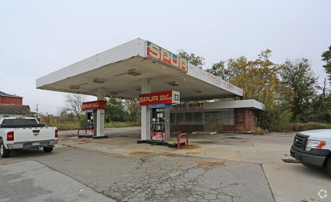
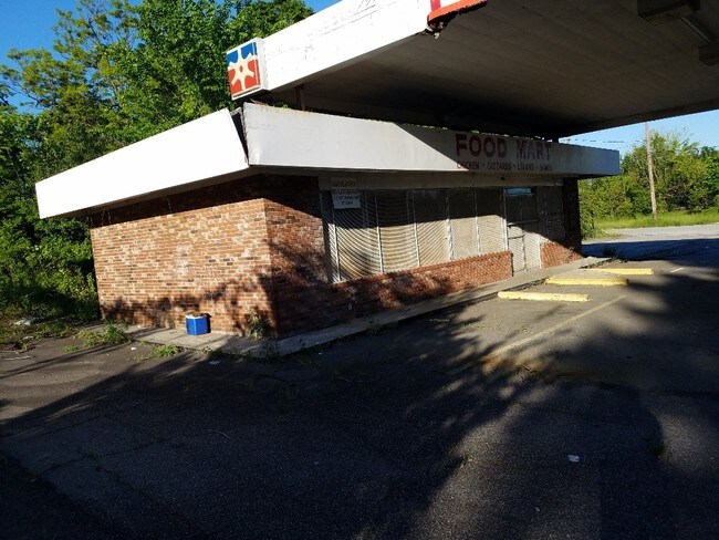
Property Record
711 Laney Walker Blvd, Augusta, GA 30901

Property Detail
711 Laney Walker Blvd
0592155000
711 LANEY WALKER BLVD
Commercialacreage
Richmond
B-2
Georgia
B and X Area of moderate flood hazard, usually the area between the limits of the 100-year and 500-year floods.
0.36 AC
2025
Downtown Augusta
2025
Augusta/Richmond County
000700
Augusta-Richmond County, GA-SC
800 SF
NEARBY LISTINGS FOR SALE OR LEASE
DEMOGRAPHICS near 711 Laney Walker Blvd
1 mile
3 mile
5 mile
2025 Total Population
6,615
41,672
99,205
2030 Population
6,854
42,791
101,253
Pop Growth 2025-2030
+ 3.61%
+ 2.69%
+ 2.06%
Average Age
44
40
40
2025 Total Households
3,145
18,544
42,670
HH Growth 2025-2030
+ 3.59%
+ 2.86%
+ 2.19%
Median Household Inc
$23,188
$36,175
$47,329
Avg Household Size
1.90
2.10
2.20
2025 Avg HH Vehicles
1.00
1.00
2.00
Median Home Value
$131,635
$173,558
$187,464
Median Year Built
1960
1959
1965
Nearby Places
Map Layers
Map Styles
 Street
 Aerial
Layers
 Traffic
 Biking
Places
Listings with unknown addresses are not visible on the map
- Restaurants
- Banks
- Shops
- Fitness
- Groceries
PUBLIC TRANSPORTATION
AIRPORT
Augusta Regional at Bush Field
Drive
Walk
Distance
Augusta Regional at Bush Field
14 min
7.6 mi
Freight Ports
Georgia Ports - Savannah
Drive
Walk
Distance
Georgia Ports - Savannah
1 min
104.0 mi
SALE & LEASE HISTORY
LISTING DATE
SALE/LEASE

Nov 15, 2017
For Sale
May 15, 2019
For Sale
Mar 29, 2017
For Sale
Nearby Properties
Address
Land Use
TOTAL SIZE
Lot Size
Zoning
Address
Land Use
TOTAL SIZE
Lot Size
Zoning
954,084 SF
18.30 AC
B-2
Address
Land Use
TOTAL SIZE
Lot Size
Zoning
52,025 SF
6.46 AC
Address
Land Use
TOTAL SIZE
Lot Size
Zoning
627,990 SF
20 AC
P-1
Address
Land Use
TOTAL SIZE
Lot Size
Zoning
87,336 SF
32.85 AC
Address
Land Use
TOTAL SIZE
Lot Size
Zoning
197,726 SF
2.93 AC
B-2
Address
Land Use
TOTAL SIZE
Lot Size
Zoning
169,662 SF
3.09 AC
B-2
Address
Land Use
TOTAL SIZE
Lot Size
Zoning
202,994 SF
19.25 AC
P-1
Address
Land Use
TOTAL SIZE
Lot Size
Zoning
179,743 SF
9.52 AC
007
Address
Land Use
TOTAL SIZE
Lot Size
Zoning
102,429 SF
7.31 AC
PUD
Address
Land Use
TOTAL SIZE
Lot Size
Zoning
255,834 SF
5.56 AC
B-1
Address
Land Use
TOTAL SIZE
Lot Size
Zoning
102,748 SF
22.60 AC
R-3B
Address
Land Use
TOTAL SIZE
Lot Size
Zoning
179,779 SF
5.91 AC
B-2
Address
Land Use
TOTAL SIZE
Lot Size
Zoning
1,000 SF
4.45 AC
Address
Land Use
TOTAL SIZE
Lot Size
Zoning
267,960 SF
2.13 AC
B-2
Address
Land Use
TOTAL SIZE
Lot Size
Zoning
152,352 SF
1.51 AC
Address
Land Use
TOTAL SIZE
Lot Size
Zoning
137,062 SF
4.45 AC
B-2
Address
Land Use
TOTAL SIZE
Lot Size
Zoning
127,728 SF
1.34 AC
B-2
Address
Land Use
TOTAL SIZE
Lot Size
Zoning
88,279 SF
19.63 AC
R-1C
Address
Land Use
TOTAL SIZE
Lot Size
Zoning
109,076 SF
4.23 AC
R-3C
Address
Land Use
TOTAL SIZE
Lot Size
Zoning
106,500 SF
1.41 AC
Address
Land Use
TOTAL SIZE
Lot Size
Zoning
21,615 SF
207.78 AC
R-1
Address
Land Use
TOTAL SIZE
Lot Size
Zoning
225,546 SF
1.28 AC
B-2
Address
Land Use
TOTAL SIZE
Lot Size
Zoning
90,447 SF
1.28 AC
B-1
Address
Land Use
TOTAL SIZE
Lot Size
Zoning
431,971 SF
21.07 AC
007
Address
Land Use
TOTAL SIZE
Lot Size
Zoning
17,954 SF
6.61 AC
LI
Address
Land Use
TOTAL SIZE
Lot Size
Zoning
94,850 SF
0.90 AC
B-2
Address
Land Use
TOTAL SIZE
Lot Size
Zoning
4,507 SF
56.06 AC
HI
Address
Land Use
TOTAL SIZE
Lot Size
Zoning
97,846 SF
1.85 AC
B-2
Address
Land Use
TOTAL SIZE
Lot Size
Zoning
73,064 SF
3.11 AC
B-1 SPEX
Address
Land Use
TOTAL SIZE
Lot Size
Zoning
5,544 SF
3.56 AC
PUD
The World's #1 Commercial Real Estate Marketplace
Connect with us
© 2026 CoStar Group
The information above has been obtained from sources believed reliable. While we do not doubt its accuracy we have not verified it and make no guarantee, warranty or representation about it. It is your responsibility to independently confirm its accuracy and completeness. Any projections, opinions, assumptions, or estimates used are for example only and do not represent the current or future performance of the property. The value of this transaction to you depends on tax and other factors which should be evaluated by your tax, financial, and legal advisors. You and your advisors should conduct a careful, independent investigation of the property to determine to your satisfaction the suitability of the property for your needs.