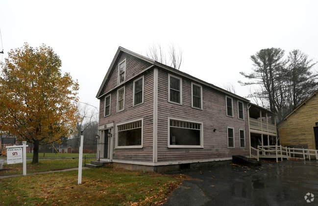
Property Record
711 Main St, Bolton, MA 01740

Save to a Folder
{{folder.Name}}
{{folder.ListingIds.length}} Properties
{{folder.ListingIds.length}} Property
Create a New Folder
Property Detail
711 Main St
BOLT-000001-000000-000004
Worcester
Commercialofficeresidentialmixeduse
Massachusetts
R1
4
AE The base floodplain where base flood elevations are provided. AE Zones are now used on new format FIRMs instead of A1-A30 Zones.
0.27 AC
2025
Outlying Worcester
2025
Boston
715100
Worcester, MA
3,909 SF
NEARBY LISTINGS FOR SALE OR LEASE
-
-
View all Bolton listings for sale on LoopNet.com
DEMOGRAPHICS near 711 Main St
1 mile
3 mile
5 mile
2025 Total Population
1,123
11,301
54,916
2030 Population
1,158
11,662
56,655
Pop Growth 2025-2030
+ 3.12%
+ 3.19%
+ 3.17%
Average Age
42
42
42
2025 Total Households
385
4,156
21,749
HH Growth 2025-2030
+ 3.12%
+ 3.22%
+ 3.22%
Median Household Inc
$187,499
$149,807
$114,751
Avg Household Size
2.90
2.70
2.50
2025 Avg HH Vehicles
2.00
2.00
2.00
Median Home Value
$767,723
$704,692
$545,915
Median Year Built
1986
1982
1970
Nearby Places
Map Layers
Map Styles
 Street
 Aerial
Layers
 Traffic
 Biking
Places
Listings with unknown addresses are not visible on the map
- Restaurants
- Banks
- Shops
- Fitness
- Groceries
PUBLIC TRANSPORTATION
COMMUTER RAIL
South Acton (Fitchburg/South Acton Line - Massachusetts Bay Transportation Authority Commuter Rail (Purple Line))
Drive
Walk
Distance
South Acton (Fitchburg/South Acton Line - Massachusetts Bay Transportation Authority Commuter Rail (Purple Line))
20 min
9.5 mi
AIRPORT
Worcester Regional
Drive
Walk
Distance
Worcester Regional
35 min
24.4 mi
Manchester Boston Regional
Drive
Walk
Distance
Manchester Boston Regional
64 min
44.7 mi
General Edward Lawrence Logan International
Drive
Walk
Distance
General Edward Lawrence Logan International
59 min
45.2 mi
Freight Ports
Port of Boston
Drive
Walk
Distance
Port of Boston
58 min
43.5 mi
Nearby Properties
Address
Land Use
TOTAL SIZE
Lot Size
Zoning
Address
Land Use
TOTAL SIZE
Lot Size
Zoning
12.42 AC
M1
Address
Land Use
TOTAL SIZE
Lot Size
Zoning
118,126 SF
82.89 AC
Address
Land Use
TOTAL SIZE
Lot Size
Zoning
119,850 SF
49.66 AC
LC1
Address
Land Use
TOTAL SIZE
Lot Size
Zoning
80,722 SF
27.01 AC
SA8
Address
Land Use
TOTAL SIZE
Lot Size
Zoning
10 AC
SA8
Address
Land Use
TOTAL SIZE
Lot Size
Zoning
138,734 SF
16.03 AC
LCI1
Address
Land Use
TOTAL SIZE
Lot Size
Zoning
134,550 SF
19.76 AC
R1
Address
Land Use
TOTAL SIZE
Lot Size
Zoning
274,042 SF
72.39 AC
I
Address
Land Use
TOTAL SIZE
Lot Size
Zoning
158,900 SF
80 AC
Address
Land Use
TOTAL SIZE
Lot Size
Zoning
884 SF
59.40 AC
R1
Address
Land Use
TOTAL SIZE
Lot Size
Zoning
104,219 SF
6.59 AC
C
Address
Land Use
TOTAL SIZE
Lot Size
Zoning
201,446 SF
47.61 AC
R1
Address
Land Use
TOTAL SIZE
Lot Size
Zoning
32,924 SF
1.80 AC
LCI1
Address
Land Use
TOTAL SIZE
Lot Size
Zoning
21,164 SF
2.66 AC
R1
Address
Land Use
TOTAL SIZE
Lot Size
Zoning
29,272 SF
11.45 AC
R1
Address
Land Use
TOTAL SIZE
Lot Size
Zoning
22,196 SF
101.91 AC
R1
Address
Land Use
TOTAL SIZE
Lot Size
Zoning
16,250 SF
1.84 AC
R1
Address
Land Use
TOTAL SIZE
Lot Size
Zoning
49,608 SF
4.85 AC
M1
Address
Land Use
TOTAL SIZE
Lot Size
Zoning
225 SF
19.57 AC
C
Address
Land Use
TOTAL SIZE
Lot Size
Zoning
43,218 SF
2.66 AC
C13
Address
Land Use
TOTAL SIZE
Lot Size
Zoning
488 SF
63.90 AC
R1
Address
Land Use
TOTAL SIZE
Lot Size
Zoning
936 SF
6.90 AC
R1
Address
Land Use
TOTAL SIZE
Lot Size
Zoning
39,281 SF
7.19 AC
R1
Address
Land Use
TOTAL SIZE
Lot Size
Zoning
23,134 SF
4.40 AC
M1
Address
Land Use
TOTAL SIZE
Lot Size
Zoning
1,185 SF
146.50 AC
R1
Address
Land Use
TOTAL SIZE
Lot Size
Zoning
15,358 SF
2.64 AC
C
Address
Land Use
TOTAL SIZE
Lot Size
Zoning
10,378 SF
1.91 AC
SA8
Address
Land Use
TOTAL SIZE
Lot Size
Zoning
17,158 SF
3.16 AC
C
Address
Land Use
TOTAL SIZE
Lot Size
Zoning
17,716 SF
0.80 AC
LCI1
Address
Land Use
TOTAL SIZE
Lot Size
Zoning
7,260 SF
5.17 AC
SA8
The World's #1 Commercial Real Estate Marketplace
Connect with us
© 2026 CoStar Group
The information above has been obtained from sources believed reliable. While we do not doubt its accuracy we have not verified it and make no guarantee, warranty or representation about it. It is your responsibility to independently confirm its accuracy and completeness. Any projections, opinions, assumptions, or estimates used are for example only and do not represent the current or future performance of the property. The value of this transaction to you depends on tax and other factors which should be evaluated by your tax, financial, and legal advisors. You and your advisors should conduct a careful, independent investigation of the property to determine to your satisfaction the suitability of the property for your needs.