Property Record
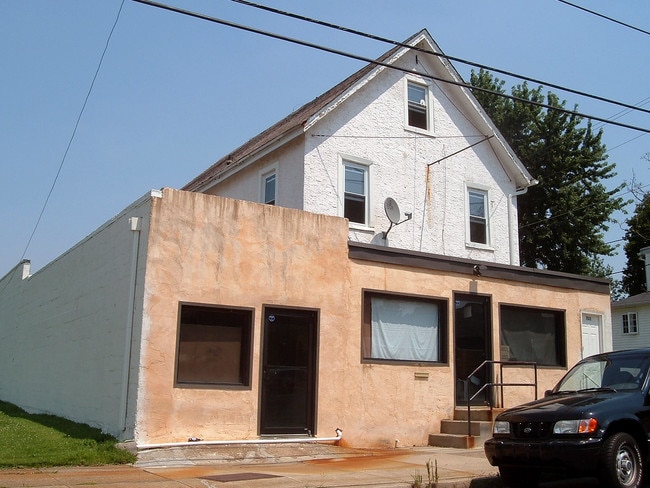
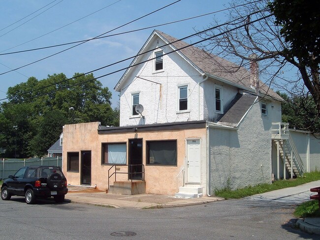
711 Main St, Marcus Hook, PA 19061

Property Detail
711 Main St
46-00-00299-00
2 STY HSE APT 1 STY LEAN TO
Restaurantbuilding
Delaware
AE The base floodplain where base flood elevations are provided. AE Zones are now used on new format FIRMs instead of A1-A30 Zones.
Pennsylvania
2025
0.13 AC
2025
Delaware County
406500
Philadelphia
5,562 SF
Philadelphia-Camden-Wilmington, PA-NJ-DE-MD
NEARBY LISTINGS FOR SALE OR LEASE
DEMOGRAPHICS near 711 Main St
1 mile
3 mile
5 mile
2025 Total Population
13,442
69,255
163,776
2030 Population
13,934
71,261
167,650
Pop Growth 2025-2030
+ 3.66%
+ 2.90%
+ 2.37%
Average Age
37
40
40
2025 Total Households
5,016
27,317
63,263
HH Growth 2025-2030
+ 3.77%
+ 2.95%
+ 2.44%
Median Household Inc
$50,913
$63,504
$74,565
Avg Household Size
2.60
2.50
2.50
2025 Avg HH Vehicles
1.00
1.00
2.00
Median Home Value
$110,879
$223,957
$290,439
Median Year Built
1949
1959
1962
Nearby Places
Map Layers
Map Styles
 Street
 Aerial
Layers
 Traffic
 Biking
Places
Listings with unknown addresses are not visible on the map
- Restaurants
- Banks
- Shops
- Fitness
- Groceries
PUBLIC TRANSPORTATION
COMMUTER RAIL
Highland Avenue (R2 - Southeastern Pennsylvania Transportation Authority Regional Rail (SEPTA Regional Rail))
Drive
Walk
Distance
Highland Avenue (R2 - Southeastern Pennsylvania Transportation Authority Regional Rail (SEPTA Regional Rail))
2 min
1.1 mi
Marcus Hook (R2 - Southeastern Pennsylvania Transportation Authority Regional Rail (SEPTA Regional Rail))
Drive
Walk
Distance
Marcus Hook (R2 - Southeastern Pennsylvania Transportation Authority Regional Rail (SEPTA Regional Rail))
2 min
20 min
1.1 mi
AIRPORT
Philadelphia International
Drive
Walk
Distance
Philadelphia International
18 min
10.7 mi
Freight Ports
Port of Wilmington, RI
Drive
Walk
Distance
Port of Wilmington, RI
20 min
12.8 mi
Nearby Properties
Address
Land Use
TOTAL SIZE
Lot Size
Zoning
Address
Land Use
TOTAL SIZE
Lot Size
Zoning
Address
Land Use
TOTAL SIZE
Lot Size
Zoning
496,028 SF
0.53 AC
Address
Land Use
TOTAL SIZE
Lot Size
Zoning
237,414 SF
27.22 AC
Address
Land Use
TOTAL SIZE
Lot Size
Zoning
26,424 SF
341 AC
Address
Land Use
TOTAL SIZE
Lot Size
Zoning
141,978 SF
2.11 AC
Address
Land Use
TOTAL SIZE
Lot Size
Zoning
167.83 AC
LI
Address
Land Use
TOTAL SIZE
Lot Size
Zoning
36.50 AC
Address
Land Use
TOTAL SIZE
Lot Size
Zoning
74,532 SF
2.15 AC
Address
Land Use
TOTAL SIZE
Lot Size
Zoning
359,520 SF
28.18 AC
HI
Address
Land Use
TOTAL SIZE
Lot Size
Zoning
258.38 AC
HI
Address
Land Use
TOTAL SIZE
Lot Size
Zoning
492,750 SF
11.50 AC
Address
Land Use
TOTAL SIZE
Lot Size
Zoning
164,862 SF
10.70 AC
Address
Land Use
TOTAL SIZE
Lot Size
Zoning
297,333 SF
11.95 AC
NCAP
Address
Land Use
TOTAL SIZE
Lot Size
Zoning
5,200 SF
6.47 AC
Address
Land Use
TOTAL SIZE
Lot Size
Zoning
297,108 SF
5.74 AC
NCAP
Address
Land Use
TOTAL SIZE
Lot Size
Zoning
282,932 SF
20.12 AC
NCAP
Address
Land Use
TOTAL SIZE
Lot Size
Zoning
15,880 SF
27.07 AC
Address
Land Use
TOTAL SIZE
Lot Size
Zoning
23,179 SF
2 AC
Address
Land Use
TOTAL SIZE
Lot Size
Zoning
161,707 SF
56 AC
Address
Land Use
TOTAL SIZE
Lot Size
Zoning
95,760 SF
20 AC
Address
Land Use
TOTAL SIZE
Lot Size
Zoning
22,140 SF
16 AC
Address
Land Use
TOTAL SIZE
Lot Size
Zoning
114,192 SF
7.84 AC
CR
Address
Land Use
TOTAL SIZE
Lot Size
Zoning
254,414 SF
18.10 AC
Address
Land Use
TOTAL SIZE
Lot Size
Zoning
401,000 SF
10 AC
Address
Land Use
TOTAL SIZE
Lot Size
Zoning
232,890 SF
4.30 AC
NCAP
Address
Land Use
TOTAL SIZE
Lot Size
Zoning
148,451 SF
22.82 AC
Address
Land Use
TOTAL SIZE
Lot Size
Zoning
37,216 SF
7.68 AC
Address
Land Use
TOTAL SIZE
Lot Size
Zoning
88,396 SF
58 AC
Address
Land Use
TOTAL SIZE
Lot Size
Zoning
10,716 SF
14.34 AC
Address
Land Use
TOTAL SIZE
Lot Size
Zoning
208,352 SF
21 AC
The World's #1 Commercial Real Estate Marketplace
Connect with us
© 2026 CoStar Group
The information above has been obtained from sources believed reliable. While we do not doubt its accuracy we have not verified it and make no guarantee, warranty or representation about it. It is your responsibility to independently confirm its accuracy and completeness. Any projections, opinions, assumptions, or estimates used are for example only and do not represent the current or future performance of the property. The value of this transaction to you depends on tax and other factors which should be evaluated by your tax, financial, and legal advisors. You and your advisors should conduct a careful, independent investigation of the property to determine to your satisfaction the suitability of the property for your needs.