Property Record
711 Old Ritchie Rd, Capitol Heights, MD 20743
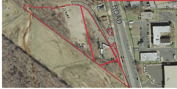


Property Detail
711 Old Ritchie Rd
18-2110138
PT CONCORD
Industrialgeneral
PRINCE GEORGE'S
IE
Maryland
B and X Area of moderate flood hazard, usually the area between the limits of the 100-year and 500-year floods.
1.03 AC
2024
Landover/Largo/Captl Hts
2025
Washington, DC
802803
Washington-Arlington-Alexandria, DC-VA-MD-WV
1,120 SF
NEARBY LISTINGS FOR SALE OR LEASE
DEMOGRAPHICS near 711 Old Ritchie Rd
1 mile
3 mile
5 mile
2025 Total Population
3,620
100,095
290,509
2030 Population
3,649
101,418
297,794
Pop Growth 2025-2030
+ 0.80%
+ 1.32%
+ 2.51%
Average Age
42
41
40
2025 Total Households
1,283
38,967
110,507
HH Growth 2025-2030
+ 0.86%
+ 1.46%
+ 2.70%
Median Household Inc
$121,276
$92,803
$88,697
Avg Household Size
2.70
2.50
2.60
2025 Avg HH Vehicles
2.00
2.00
2.00
Median Home Value
$382,507
$351,197
$375,782
Median Year Built
1975
1981
1976
Nearby Places
Map Layers
Map Styles
 Street
 Aerial
Layers
 Traffic
 Biking
Places
Listings with unknown addresses are not visible on the map
- Restaurants
- Banks
- Shops
- Fitness
- Groceries
PUBLIC TRANSPORTATION
COMMUTER RAIL
New Carrollton (Penn Line - Maryland Area Regional Commuter Trains (The MARC))
Drive
Walk
Distance
New Carrollton (Penn Line - Maryland Area Regional Commuter Trains (The MARC))
13 min
8.1 mi
Drive
Walk
Distance
14 min
8.1 mi
AIRPORT
Ronald Reagan Washington Ntl
Drive
Walk
Distance
Ronald Reagan Washington Ntl
28 min
15.1 mi
Baltimore/Washington International Thurgood Marshall
Drive
Walk
Distance
Baltimore/Washington International Thurgood Marshall
44 min
29.3 mi
Washington Dulles International
Drive
Walk
Distance
Washington Dulles International
62 min
37.8 mi
Freight Ports
Port of Baltimore
Drive
Walk
Distance
Port of Baltimore
52 min
35.6 mi
SALE & LEASE HISTORY
LISTING DATE
SALE/LEASE

Oct 15, 2018
For Lease
Nov 13, 2017
For Sale
May 13, 2017
For Lease
May 13, 2017
For Sale
Mar 29, 2017
For Sale
Jun 13, 2025
For Lease
Jun 12, 2019
For Sale
Aug 19, 2022
For Lease
Nearby Properties
Address
Land Use
TOTAL SIZE
Lot Size
Zoning
Address
Land Use
TOTAL SIZE
Lot Size
Zoning
35.03 AC
LTOE
Address
Land Use
TOTAL SIZE
Lot Size
Zoning
177,081 SF
23.22 AC
LCD
Address
Land Use
TOTAL SIZE
Lot Size
Zoning
5.10 AC
RTOHC
Address
Land Use
TOTAL SIZE
Lot Size
Zoning
12.60 AC
LTOC
Address
Land Use
TOTAL SIZE
Lot Size
Zoning
129,712 SF
150.08 AC
RR
Address
Land Use
TOTAL SIZE
Lot Size
Zoning
7.72 AC
CGO
Address
Land Use
TOTAL SIZE
Lot Size
Zoning
100 SF
4.78 AC
RTOHC
Address
Land Use
TOTAL SIZE
Lot Size
Zoning
315 SF
6.62 AC
RTOHE
Address
Land Use
TOTAL SIZE
Lot Size
Zoning
386,775 SF
45.40 AC
RMF20
Address
Land Use
TOTAL SIZE
Lot Size
Zoning
456,950 SF
52.92 AC
CGO
Address
Land Use
TOTAL SIZE
Lot Size
Zoning
262 SF
24.86 AC
RMF20
Address
Land Use
TOTAL SIZE
Lot Size
Zoning
344 SF
23.70 AC
RMF12
Address
Land Use
TOTAL SIZE
Lot Size
Zoning
491,397 SF
6.20 AC
RTOHE
Address
Land Use
TOTAL SIZE
Lot Size
Zoning
386,326 SF
62.74 AC
IE
Address
Land Use
TOTAL SIZE
Lot Size
Zoning
9.67 AC
RMF48
Address
Land Use
TOTAL SIZE
Lot Size
Zoning
4,704 SF
7.20 AC
RMF48
Address
Land Use
TOTAL SIZE
Lot Size
Zoning
217,500 SF
12.95 AC
RTOHE
Address
Land Use
TOTAL SIZE
Lot Size
Zoning
34.38 AC
RMF12
Address
Land Use
TOTAL SIZE
Lot Size
Zoning
14.36 AC
RMF48
Address
Land Use
TOTAL SIZE
Lot Size
Zoning
223,600 SF
13.34 AC
IE
Address
Land Use
TOTAL SIZE
Lot Size
Zoning
5.58 AC
CGO
Address
Land Use
TOTAL SIZE
Lot Size
Zoning
259,911 SF
24.14 AC
RTOHE
Address
Land Use
TOTAL SIZE
Lot Size
Zoning
57,288 SF
6.94 AC
TACE
Address
Land Use
TOTAL SIZE
Lot Size
Zoning
26 SF
9.44 AC
RTOHE
Address
Land Use
TOTAL SIZE
Lot Size
Zoning
219,287 SF
24.46 AC
CGO
Address
Land Use
TOTAL SIZE
Lot Size
Zoning
182,000 SF
3.69 AC
RTOHE
Address
Land Use
TOTAL SIZE
Lot Size
Zoning
238,785 SF
12.79 AC
CGO
Address
Land Use
TOTAL SIZE
Lot Size
Zoning
125,000 SF
1.03 AC
RTOHC
Address
Land Use
TOTAL SIZE
Lot Size
Zoning
133,840 SF
33.35 AC
IE
Address
Land Use
TOTAL SIZE
Lot Size
Zoning
159,120 SF
10.25 AC
IE
The World's #1 Commercial Real Estate Marketplace
Connect with us
© 2026 CoStar Group
The information above has been obtained from sources believed reliable. While we do not doubt its accuracy we have not verified it and make no guarantee, warranty or representation about it. It is your responsibility to independently confirm its accuracy and completeness. Any projections, opinions, assumptions, or estimates used are for example only and do not represent the current or future performance of the property. The value of this transaction to you depends on tax and other factors which should be evaluated by your tax, financial, and legal advisors. You and your advisors should conduct a careful, independent investigation of the property to determine to your satisfaction the suitability of the property for your needs.