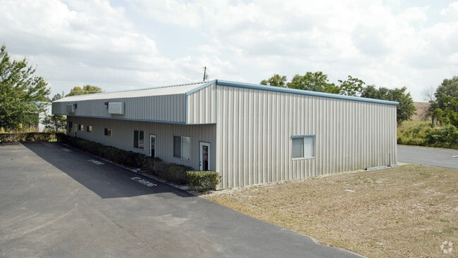
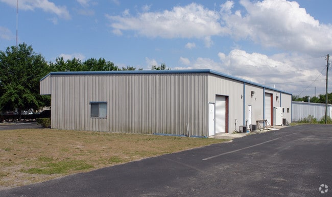
Property Record
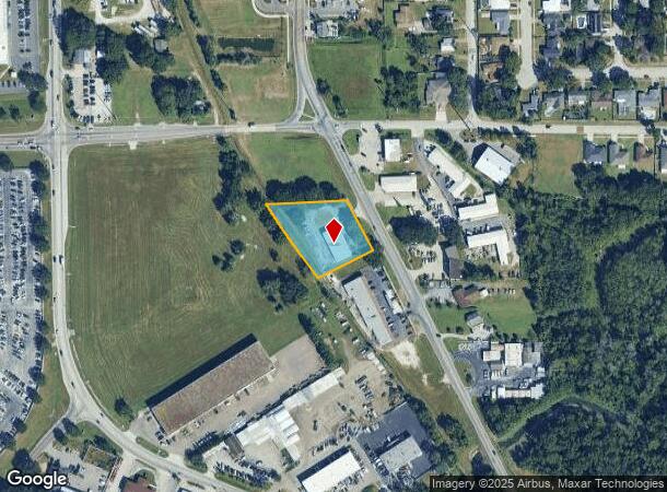
711 S Bluford Ave, Ocoee, FL 34761
NEARBY LISTINGS FOR SALE OR LEASE
Property Detail
711 S Bluford Ave
Orlando-Kissimmee-Sanford, FL
Courtleigh Park
19-2228-0000-00-070
COMM NE COR OF SE1/4 RUN S 88 DEG W 484.73 FT TH S 25 DEG E 419.27 FT TO WLY R/W OF BLUFORD AV FOR POB TH S 64 DEG W 182 .34 FT TO C/L OF RR R/W TH CONT S 64 DEG W 30.46 FT TO WLY L
Warehouse
Orange
AE
Florida
12095C0220H
70
2025
1.11 AC
2025
West Colonial
014906
Orlando
5,036 SF
DEMOGRAPHICS near 711 S Bluford Ave
1 mile
3 mile
5 mile
2024 Total Population
4,316
70,199
176,742
2029 Population
4,386
72,182
182,031
Pop Growth 2024-2029
+ 1.62%
+ 2.82%
+ 2.99%
Average Age
42
40
39
2024 Total Households
1,544
24,153
60,565
HH Growth 2024-2029
+ 1.42%
+ 2.82%
+ 3.03%
Median Household Inc
$81,229
$72,224
$70,403
Avg Household Size
2.70
2.80
2.90
2024 Avg HH Vehicles
2.00
2.00
2.00
Median Home Value
$339,598
$325,158
$329,220
Median Year Built
1993
1994
1993
Nearby Places
Map Layers
Map Styles
 Street
 Aerial
Transit
 Traffic
 Biking
Places
Listings with unknown addresses are not visible on the map
- Restaurants
- Banks
- Shops
- Fitness
- Groceries
PUBLIC TRANSPORTATION
AIRPORT
Orlando International
Drive
Walk
Distance
Orlando International
32 min
23.0 mi
Orlando Sanford International
Drive
Walk
Distance
Orlando Sanford International
49 min
37.8 mi
Nearby Properties
Address
Land Use
TOTAL SIZE
Lot Size
Zoning
Address
Land Use
TOTAL SIZE
Lot Size
Zoning
840,260 SF
65.85 AC
C-2
Address
Land Use
TOTAL SIZE
Lot Size
Zoning
481,795 SF
16.56 AC
I-1
Address
Land Use
TOTAL SIZE
Lot Size
Zoning
669,041 SF
43.79 AC
I-1
Address
Land Use
TOTAL SIZE
Lot Size
Zoning
782,050 SF
44.78 AC
A-1
Address
Land Use
TOTAL SIZE
Lot Size
Zoning
321,759 SF
PUD-HD
Address
Land Use
TOTAL SIZE
Lot Size
Zoning
693,608 SF
24.41 AC
PUD-HD
Address
Land Use
TOTAL SIZE
Lot Size
Zoning
387,922 SF
27.44 AC
P-D
Address
Land Use
TOTAL SIZE
Lot Size
Zoning
368,910 SF
14.02 AC
CAPUD
Address
Land Use
TOTAL SIZE
Lot Size
Zoning
342,875 SF
11.35 AC
PUD-COMM
Address
Land Use
TOTAL SIZE
Lot Size
Zoning
446,425 SF
25.15 AC
PUD-IND
Address
Land Use
TOTAL SIZE
Lot Size
Zoning
347,605 SF
9.10 AC
C-2
Address
Land Use
TOTAL SIZE
Lot Size
Zoning
347,506 SF
3.55 AC
PUD-MD
Address
Land Use
TOTAL SIZE
Lot Size
Zoning
167,285 SF
164.77 AC
C-3
Address
Land Use
TOTAL SIZE
Lot Size
Zoning
314,643 SF
38.04 AC
PUD
Address
Land Use
TOTAL SIZE
Lot Size
Zoning
263,067 SF
41.46 AC
P-D
Address
Land Use
TOTAL SIZE
Lot Size
Zoning
265,223 SF
1.89 AC
R-3
Address
Land Use
TOTAL SIZE
Lot Size
Zoning
209,545 SF
20.04 AC
R-3
Address
Land Use
TOTAL SIZE
Lot Size
Zoning
203,729 SF
11.46 AC
PUD-HD
Address
Land Use
TOTAL SIZE
Lot Size
Zoning
196,924 SF
2.53 AC
P-S
Address
Land Use
TOTAL SIZE
Lot Size
Zoning
221,959 SF
10.82 AC
P-D
Address
Land Use
TOTAL SIZE
Lot Size
Zoning
493,556 SF
28.89 AC
I-2
Address
Land Use
TOTAL SIZE
Lot Size
Zoning
167,486 SF
14.70 AC
R-1A
Address
Land Use
TOTAL SIZE
Lot Size
Zoning
80,744 SF
9.40 AC
R-2
Address
Land Use
TOTAL SIZE
Lot Size
Zoning
352,671 SF
25.54 AC
P-D
Address
Land Use
TOTAL SIZE
Lot Size
Zoning
173,880 SF
30.87 AC
P-D
Address
Land Use
TOTAL SIZE
Lot Size
Zoning
179,371 SF
21.52 AC
A-1
Address
Land Use
TOTAL SIZE
Lot Size
Zoning
261,608 SF
21.73 AC
C-2
Address
Land Use
TOTAL SIZE
Lot Size
Zoning
183,582 SF
16.82 AC
C-2
Address
Land Use
TOTAL SIZE
Lot Size
Zoning
169,734 SF
2.46 AC
R-3
Address
Land Use
TOTAL SIZE
Lot Size
Zoning
151,838 SF
7.15 AC
R-1
The World's #1 Commercial Real Estate Marketplace
Connect with us
© 2026 CoStar Group
The information above has been obtained from sources believed reliable. While we do not doubt its accuracy we have not verified it and make no guarantee, warranty or representation about it. It is your responsibility to independently confirm its accuracy and completeness. Any projections, opinions, assumptions, or estimates used are for example only and do not represent the current or future performance of the property. The value of this transaction to you depends on tax and other factors which should be evaluated by your tax, financial, and legal advisors. You and your advisors should conduct a careful, independent investigation of the property to determine to your satisfaction the suitability of the property for your needs.