Property Record
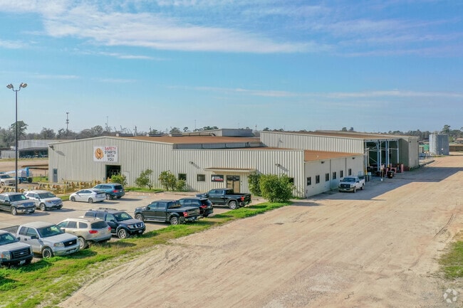
711 Shields St, Channelview, TX 77530


Property Detail
711 Shields St
1308990030001
RES C BLK 3 LABARGE PIPE & STEEL COMPANY SEC 1
Warehouse
HARRIS
B and X Area of moderate flood hazard, usually the area between the limits of the 100-year and 500-year floods.
Texas
2024
62.49 AC
2025
Northeast Hwy 90
252602
Houston
88,843 SF
Houston-Pasadena-The Woodlands, TX
NEARBY LISTINGS FOR SALE OR LEASE
DEMOGRAPHICS near 711 Shields St
1 mile
3 mile
5 mile
2025 Total Population
2,664
32,767
98,675
2030 Population
2,866
34,736
104,410
Pop Growth 2025-2030
+ 7.58%
+ 6.01%
+ 5.81%
Average Age
35
34
35
2025 Total Households
817
10,158
30,375
HH Growth 2025-2030
+ 7.83%
+ 6.11%
+ 5.96%
Median Household Inc
$44,901
$62,767
$65,762
Avg Household Size
3.10
3.20
3.20
2025 Avg HH Vehicles
2.00
2.00
2.00
Median Home Value
$171,290
$208,980
$217,278
Median Year Built
1987
1986
1988
Nearby Places
Map Layers
Map Styles
 Street
 Aerial
Layers
 Traffic
 Biking
Places
Listings with unknown addresses are not visible on the map
- Restaurants
- Banks
- Shops
- Fitness
- Groceries
PUBLIC TRANSPORTATION
AIRPORT
William P Hobby
Drive
Walk
Distance
William P Hobby
38 min
23.0 mi
George Bush Intcntl/Houston
Drive
Walk
Distance
George Bush Intcntl/Houston
35 min
27.1 mi
Freight Ports
Port of Houston
Drive
Walk
Distance
Port of Houston
25 min
14.9 mi
SALE & LEASE HISTORY
LISTING DATE
SALE/LEASE

Apr 27, 2023
For Lease
Apr 19, 2022
For Lease
Nearby Properties
Address
Land Use
TOTAL SIZE
Lot Size
Zoning
Address
Land Use
TOTAL SIZE
Lot Size
Zoning
Address
Land Use
TOTAL SIZE
Lot Size
Zoning
330.90 AC
Address
Land Use
TOTAL SIZE
Lot Size
Zoning
9,585,990 SF
122.92 AC
Address
Land Use
TOTAL SIZE
Lot Size
Zoning
409.44 AC
Address
Land Use
TOTAL SIZE
Lot Size
Zoning
1,056.36 AC
Address
Land Use
TOTAL SIZE
Lot Size
Zoning
183.58 AC
Address
Land Use
TOTAL SIZE
Lot Size
Zoning
315.64 AC
Address
Land Use
TOTAL SIZE
Lot Size
Zoning
338.08 AC
Address
Land Use
TOTAL SIZE
Lot Size
Zoning
33.93 AC
Address
Land Use
TOTAL SIZE
Lot Size
Zoning
760,851 SF
41.87 AC
Address
Land Use
TOTAL SIZE
Lot Size
Zoning
56.69 AC
Address
Land Use
TOTAL SIZE
Lot Size
Zoning
1,306,874 SF
6.76 AC
Address
Land Use
TOTAL SIZE
Lot Size
Zoning
485,662 SF
48.80 AC
Address
Land Use
TOTAL SIZE
Lot Size
Zoning
315.64 AC
Address
Land Use
TOTAL SIZE
Lot Size
Zoning
498,770 SF
25.23 AC
Address
Land Use
TOTAL SIZE
Lot Size
Zoning
392.95 AC
Address
Land Use
TOTAL SIZE
Lot Size
Zoning
75,870 SF
42.32 AC
Address
Land Use
TOTAL SIZE
Lot Size
Zoning
570,883 SF
33.27 AC
Address
Land Use
TOTAL SIZE
Lot Size
Zoning
168,200 SF
15 AC
Address
Land Use
TOTAL SIZE
Lot Size
Zoning
35,629 SF
50.01 AC
Address
Land Use
TOTAL SIZE
Lot Size
Zoning
392.95 AC
Address
Land Use
TOTAL SIZE
Lot Size
Zoning
181,200 SF
10.51 AC
Address
Land Use
TOTAL SIZE
Lot Size
Zoning
27,907 SF
69.57 AC
Address
Land Use
TOTAL SIZE
Lot Size
Zoning
144,000 SF
18 AC
Address
Land Use
TOTAL SIZE
Lot Size
Zoning
171,332 SF
124.91 AC
Address
Land Use
TOTAL SIZE
Lot Size
Zoning
97,429 SF
23.88 AC
Address
Land Use
TOTAL SIZE
Lot Size
Zoning
Address
Land Use
TOTAL SIZE
Lot Size
Zoning
294,674 SF
Address
Land Use
TOTAL SIZE
Lot Size
Zoning
90,500 SF
50 AC
Address
Land Use
TOTAL SIZE
Lot Size
Zoning
212,200 SF
17 AC
The World's #1 Commercial Real Estate Marketplace
Connect with us
© 2026 CoStar Group
The information above has been obtained from sources believed reliable. While we do not doubt its accuracy we have not verified it and make no guarantee, warranty or representation about it. It is your responsibility to independently confirm its accuracy and completeness. Any projections, opinions, assumptions, or estimates used are for example only and do not represent the current or future performance of the property. The value of this transaction to you depends on tax and other factors which should be evaluated by your tax, financial, and legal advisors. You and your advisors should conduct a careful, independent investigation of the property to determine to your satisfaction the suitability of the property for your needs.