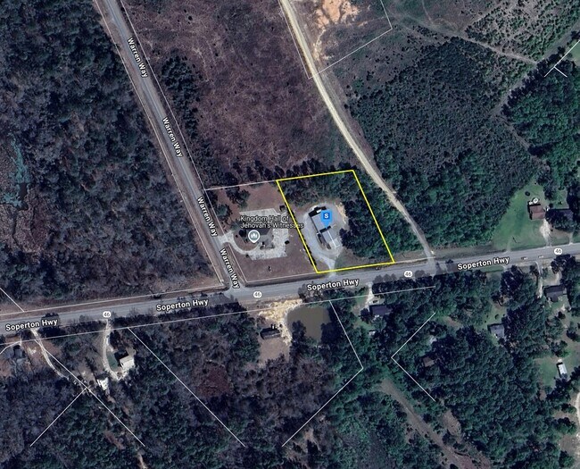
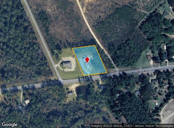
Property Record
711 Soperton Hwy, Eastman, GA 31023
NEARBY LISTINGS FOR SALE OR LEASE
-
-
View all Eastman listings for sale on LoopNet.com
Property Detail
711 Soperton Hwy
0060B-00000-091-B00
Map 60B Comm
Publicstorage
LL 278 LD 16 2 AC
X
Dodge
13091C0185C
Georgia
2025
278
2025
2 AC
960400
Georgia South Area
4,840 SF
Other Market Areas
DEMOGRAPHICS near 711 Soperton Hwy
1 Mile
3 Mile
5 Mile
2024 Total Population
1,816
8,046
9,890
2029 Population
1,735
7,849
9,651
Pop Growth 2024-2029
(4.46%)
(2.45%)
(2.42%)
Average Age
40
41
41
2024 Total Households
674
3,167
3,878
HH Growth 2024-2029
(4.60%)
(2.34%)
(2.32%)
Median Household Inc
$38,555
$37,717
$39,475
Avg Household Size
2.50
2.40
2.40
2024 Avg HH Vehicles
2.00
2.00
2.00
Median Home Value
$104,825
$108,640
$119,982
Median Year Built
1967
1973
1974
Nearby Places
Map Layers
Map Styles
 Street
 Aerial
- Restaurants
- Banks
- Shops
- Fitness
- Groceries
Nearby Properties
Address
Land Use
TOTAL SIZE
Lot Size
Zoning
Address
Land Use
TOTAL SIZE
Lot Size
Zoning
9.14 AC
Address
Land Use
TOTAL SIZE
Lot Size
Zoning
161,156 SF
28.19 AC
Address
Land Use
TOTAL SIZE
Lot Size
Zoning
2,176 SF
10 AC
001
Address
Land Use
TOTAL SIZE
Lot Size
Zoning
20.34 AC
001
Address
Land Use
TOTAL SIZE
Lot Size
Zoning
22,952 SF
50 AC
001
Address
Land Use
TOTAL SIZE
Lot Size
Zoning
3,276 SF
5.97 AC
001
Address
Land Use
TOTAL SIZE
Lot Size
Zoning
54,312 SF
6.55 AC
001
Address
Land Use
TOTAL SIZE
Lot Size
Zoning
24,756 SF
10.22 AC
002
Address
Land Use
TOTAL SIZE
Lot Size
Zoning
17,248 SF
0.89 AC
001
Address
Land Use
TOTAL SIZE
Lot Size
Zoning
21,488 SF
1.68 AC
001
Address
Land Use
TOTAL SIZE
Lot Size
Zoning
18,264 SF
3.56 AC
Address
Land Use
TOTAL SIZE
Lot Size
Zoning
4,838 SF
2 AC
Address
Land Use
TOTAL SIZE
Lot Size
Zoning
121,880 SF
12.09 AC
003
Address
Land Use
TOTAL SIZE
Lot Size
Zoning
5,250 SF
Address
Land Use
TOTAL SIZE
Lot Size
Zoning
13,225 SF
12.80 AC
Address
Land Use
TOTAL SIZE
Lot Size
Zoning
2,720 SF
9.98 AC
001
Address
Land Use
TOTAL SIZE
Lot Size
Zoning
11,274 SF
1.24 AC
001
Address
Land Use
TOTAL SIZE
Lot Size
Zoning
15,054 SF
0.84 AC
001
Address
Land Use
TOTAL SIZE
Lot Size
Zoning
10,000 SF
10 AC
001
Address
Land Use
TOTAL SIZE
Lot Size
Zoning
5,368 SF
1.01 AC
001
Address
Land Use
TOTAL SIZE
Lot Size
Zoning
10,836 SF
1.30 AC
002
Address
Land Use
TOTAL SIZE
Lot Size
Zoning
69,804 SF
12.09 AC
003
Address
Land Use
TOTAL SIZE
Lot Size
Zoning
14,480 SF
1 AC
Address
Land Use
TOTAL SIZE
Lot Size
Zoning
2,476 SF
3.69 AC
002
Address
Land Use
TOTAL SIZE
Lot Size
Zoning
16,000 SF
5 AC
The World's #1 Commercial Real Estate Marketplace
Connect with us
© 2026 CoStar Group
The information above has been obtained from sources believed reliable. While we do not doubt its accuracy we have not verified it and make no guarantee, warranty or representation about it. It is your responsibility to independently confirm its accuracy and completeness. Any projections, opinions, assumptions, or estimates used are for example only and do not represent the current or future performance of the property. The value of this transaction to you depends on tax and other factors which should be evaluated by your tax, financial, and legal advisors. You and your advisors should conduct a careful, independent investigation of the property to determine to your satisfaction the suitability of the property for your needs.