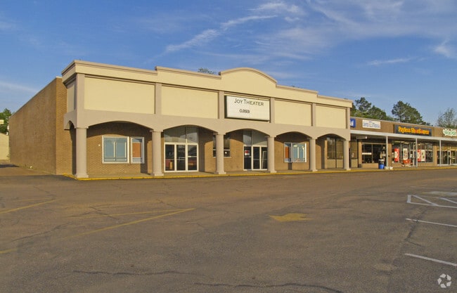
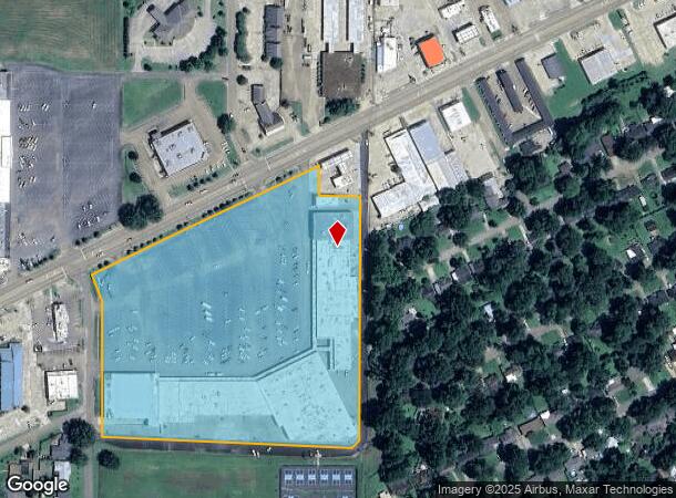
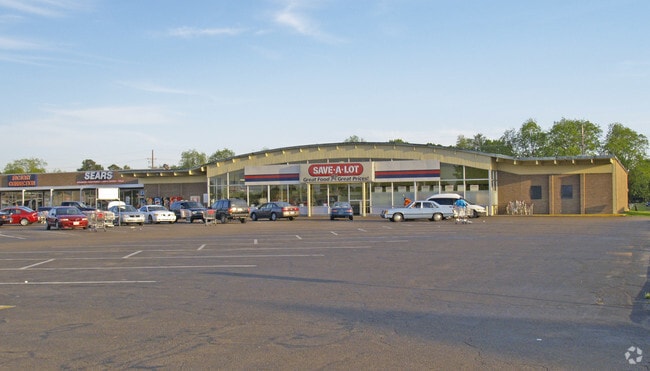
Property Record
701 W Park Ave, Greenwood, MS 38930
NEARBY LISTINGS FOR SALE OR LEASE
-
-
View all Greenwood listings for lease on LoopNet.com
Property Detail
701 W Park Ave
08509020400100
Park Subd
Storebuilding
BLOCK C LESS PART DESC DB 288 PG 484 HIGHLAND PARK SUBD (SHOPPING CENTER)
X
Leflore
28015C0125C
Mississippi
2025
11.70 AC
2025
Vicksburg/Central Area
950600
Other Market Areas
1,728 SF
Greenwood, MS
DEMOGRAPHICS near 701 W Park Ave
1 Mile
3 Mile
5 Mile
2024 Total Population
4,382
15,101
19,912
2029 Population
4,059
14,101
18,483
Pop Growth 2024-2029
(7.37%)
(6.62%)
(7.18%)
Average Age
41
38
38
2024 Total Households
1,795
6,095
7,909
HH Growth 2024-2029
(6.57%)
(5.76%)
(6.32%)
Median Household Inc
$45,040
$28,935
$29,967
Avg Household Size
2.30
2.40
2.40
2024 Avg HH Vehicles
2.00
1.00
2.00
Median Home Value
$103,021
$83,668
$84,630
Median Year Built
1965
1972
1974
Nearby Places
Map Layers
Map Styles
 Street
 Aerial
- Restaurants
- Banks
- Shops
- Fitness
- Groceries
PUBLIC TRANSPORTATION
COMMUTER RAIL
Greenwood Amtrak Station (City of New Orleans - Amtrak)
DRIVE
WALK
Distance
Greenwood Amtrak Station (City of New Orleans - Amtrak)
4 min
2.2 mi
Freight Ports
Port of Shreveport
DRIVE
WALK
Distance
Port of Shreveport
326 min
273.7 mi
SALE & LEASE HISTORY
LISTING DATE
SALE/LEASE

Sep 25, 2016
For Lease
Nearby Properties
Address
Land Use
TOTAL SIZE
Lot Size
Zoning
Address
Land Use
TOTAL SIZE
Lot Size
Zoning
193,398 SF
20.45 AC
Address
Land Use
TOTAL SIZE
Lot Size
Zoning
52,320 SF
0.64 AC
Address
Land Use
TOTAL SIZE
Lot Size
Zoning
9,830 SF
18.43 AC
Address
Land Use
TOTAL SIZE
Lot Size
Zoning
3,406 SF
26.20 AC
Address
Land Use
TOTAL SIZE
Lot Size
Zoning
828 SF
2.93 AC
Address
Land Use
TOTAL SIZE
Lot Size
Zoning
12,962 SF
12.15 AC
Address
Land Use
TOTAL SIZE
Lot Size
Zoning
7,356 SF
0.03 AC
Address
Land Use
TOTAL SIZE
Lot Size
Zoning
14,462 SF
15.93 AC
Address
Land Use
TOTAL SIZE
Lot Size
Zoning
10,701 SF
13.40 AC
Address
Land Use
TOTAL SIZE
Lot Size
Zoning
64,116 SF
6 AC
Address
Land Use
TOTAL SIZE
Lot Size
Zoning
56,250 SF
6.30 AC
Address
Land Use
TOTAL SIZE
Lot Size
Zoning
13,772 SF
69.80 AC
Address
Land Use
TOTAL SIZE
Lot Size
Zoning
12,102 SF
4.20 AC
Address
Land Use
TOTAL SIZE
Lot Size
Zoning
42,860 SF
1.94 AC
Address
Land Use
TOTAL SIZE
Lot Size
Zoning
6,039 SF
7.31 AC
Address
Land Use
TOTAL SIZE
Lot Size
Zoning
41,779 SF
1.36 AC
Address
Land Use
TOTAL SIZE
Lot Size
Zoning
6,535 SF
8.83 AC
Address
Land Use
TOTAL SIZE
Lot Size
Zoning
31,119 SF
7.90 AC
Address
Land Use
TOTAL SIZE
Lot Size
Zoning
33,398 SF
4 AC
Address
Land Use
TOTAL SIZE
Lot Size
Zoning
50,183 SF
8.30 AC
Address
Land Use
TOTAL SIZE
Lot Size
Zoning
39,234 SF
2.21 AC
Address
Land Use
TOTAL SIZE
Lot Size
Zoning
271,600 SF
63.60 AC
Address
Land Use
TOTAL SIZE
Lot Size
Zoning
2,896 SF
5.20 AC
Address
Land Use
TOTAL SIZE
Lot Size
Zoning
34,158 SF
4 AC
Address
Land Use
TOTAL SIZE
Lot Size
Zoning
8,254 SF
6.20 AC
Address
Land Use
TOTAL SIZE
Lot Size
Zoning
15,690 SF
1.64 AC
Address
Land Use
TOTAL SIZE
Lot Size
Zoning
17,640 SF
2.60 AC
Address
Land Use
TOTAL SIZE
Lot Size
Zoning
4,534 SF
2 AC
The World's #1 Commercial Real Estate Marketplace
Connect with us
© 2026 CoStar Group
The information above has been obtained from sources believed reliable. While we do not doubt its accuracy we have not verified it and make no guarantee, warranty or representation about it. It is your responsibility to independently confirm its accuracy and completeness. Any projections, opinions, assumptions, or estimates used are for example only and do not represent the current or future performance of the property. The value of this transaction to you depends on tax and other factors which should be evaluated by your tax, financial, and legal advisors. You and your advisors should conduct a careful, independent investigation of the property to determine to your satisfaction the suitability of the property for your needs.