Property Record
7110 Ditmars Blvd, East Elmhurst, NY 11370
NEARBY LISTINGS FOR SALE OR LEASE
-
-
-
-
-
-
-
-
-
-
-
-
-
-
-
-
-
-
-
No Photo
-
-
View all East Elmhurst listings for sale on LoopNet.com
Property Detail
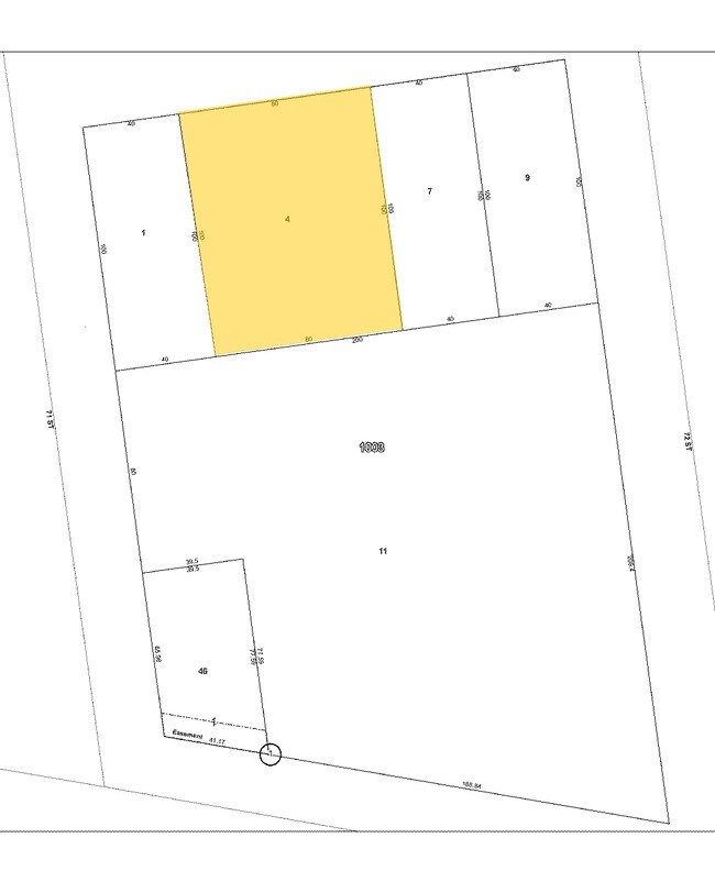
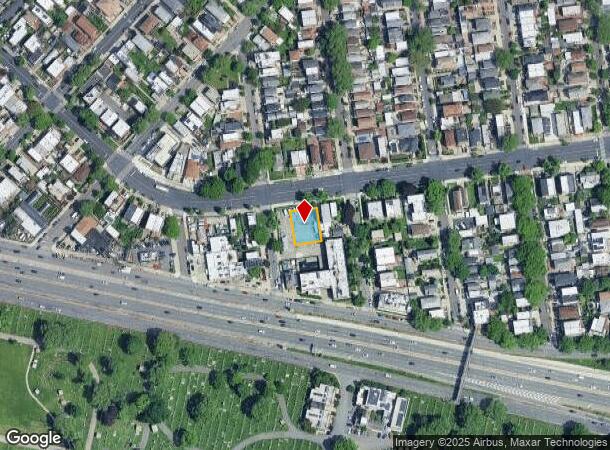
7110 Ditmars Blvd
01003-0004
Queens
Parkinglot
New York
X
4
3604970094F
0.18 AC
2024
Northeast Queens
2025
Long Island (New York)
030904
New York-Jersey City-White Plains, NY-NJ
440 SF
DEMOGRAPHICS near 7110 Ditmars Blvd
1 Mile
3 Mile
5 Mile
2024 Total Population
75,444
828,852
2,737,873
2029 Population
69,599
774,991
2,551,647
Pop Growth 2024-2029
(7.75%)
(6.50%)
(6.80%)
Average Age
40
40
40
2024 Total Households
29,527
319,413
1,125,417
HH Growth 2024-2029
(7.97%)
(6.58%)
(7.08%)
Median Household Inc
$78,230
$72,727
$71,857
Avg Household Size
2.50
2.50
2.30
2024 Avg HH Vehicles
1.00
1.00
.00
Median Home Value
$790,602
$726,048
$801,131
Median Year Built
1948
1955
1955
Nearby Places
- Restaurants
- Banks
- Shops
- Fitness
- Groceries
PUBLIC TRANSPORTATION
TRANSIT/SUBWAY
Astoria-Ditmars Boulevard (N - New York MTA Subway (The Subway), Q - New York MTA Subway (The Subway))
DRIVE
WALK
Distance
Astoria-Ditmars Boulevard (N - New York MTA Subway (The Subway), Q - New York MTA Subway (The Subway))
6 min
20 min
1.0 mi
COMMUTER RAIL
Woodside Station (Babylon Branch - Long Island Rail Road, Far Rockaway Branch - Long Island Rail Road, Hempstead Branch - Long Island Rail Road, Long Beach Branch - Long Island Rail Road, Montauk Branch - Long Island Rail Road, Port Jefferson Branch - Long Island Rail Road, Port Washington Branch - Long Island Rail Road, Ronkonkoma Branch - Long Island Rail Road)
DRIVE
WALK
Distance
Woodside Station (Babylon Branch - Long Island Rail Road, Far Rockaway Branch - Long Island Rail Road, Hempstead Branch - Long Island Rail Road, Long Beach Branch - Long Island Rail Road, Montauk Branch - Long Island Rail Road, Port Jefferson Branch - Long Island Rail Road, Port Washington Branch - Long Island Rail Road, Ronkonkoma Branch - Long Island Rail Road)
7 min
2.5 mi
Hunterspoint Avenue Station (Hempstead Branch - Long Island Rail Road, Oyster Bay Branch - Long Island Rail Road)
DRIVE
WALK
Distance
Hunterspoint Avenue Station (Hempstead Branch - Long Island Rail Road, Oyster Bay Branch - Long Island Rail Road)
12 min
5.6 mi
AIRPORT
LaGuardia
DRIVE
WALK
Distance
LaGuardia
6 min
2.3 mi
John F Kennedy International
DRIVE
WALK
Distance
John F Kennedy International
20 min
13.4 mi
Newark Liberty International
DRIVE
WALK
Distance
Newark Liberty International
36 min
28.8 mi
Nearby Properties
Address
Land Use
TOTAL SIZE
Lot Size
Zoning
Address
Land Use
TOTAL SIZE
Lot Size
Zoning
5,519,372 SF
409.21 AC
C8-2
Address
Land Use
TOTAL SIZE
Lot Size
Zoning
2,230,742 SF
6.33 AC
R9
Address
Land Use
TOTAL SIZE
Lot Size
Zoning
1,258,350 SF
410.24 AC
PARK
Address
Land Use
TOTAL SIZE
Lot Size
Zoning
1,200,000 SF
10.24 AC
R9
Address
Land Use
TOTAL SIZE
Lot Size
Zoning
1,065,915 SF
2.13 AC
M16R10
Address
Land Use
TOTAL SIZE
Lot Size
Zoning
757,439 SF
0.91 AC
C1-9
Address
Land Use
TOTAL SIZE
Lot Size
Zoning
1,502,532 SF
6.35 AC
R7B
Address
Land Use
TOTAL SIZE
Lot Size
Zoning
1,075,000 SF
6.74 AC
R7-2
Address
Land Use
TOTAL SIZE
Lot Size
Zoning
772,163 SF
5.24 AC
C4-5X
Address
Land Use
TOTAL SIZE
Lot Size
Zoning
407,259 SF
0.93 AC
C5-2
Address
Land Use
TOTAL SIZE
Lot Size
Zoning
661,538 SF
11.26 AC
R7-2
Address
Land Use
TOTAL SIZE
Lot Size
Zoning
1,359,110 SF
1.89 AC
C5-3
Address
Land Use
TOTAL SIZE
Lot Size
Zoning
527,900 SF
0.57 AC
R10
Address
Land Use
TOTAL SIZE
Lot Size
Zoning
908,799 SF
2.13 AC
R10
Address
Land Use
TOTAL SIZE
Lot Size
Zoning
234,891 SF
3.17 AC
C4-5X
Address
Land Use
TOTAL SIZE
Lot Size
Zoning
804,200 SF
5.28 AC
R7-2
Address
Land Use
TOTAL SIZE
Lot Size
Zoning
207.09 AC
PARK
Address
Land Use
TOTAL SIZE
Lot Size
Zoning
882,579 SF
0.51 AC
M16R10
Address
Land Use
TOTAL SIZE
Lot Size
Zoning
648,703 SF
1.45 AC
C28A
Address
Land Use
TOTAL SIZE
Lot Size
Zoning
505,416 SF
M16R10
Address
Land Use
TOTAL SIZE
Lot Size
Zoning
710,860 SF
1.52 AC
M15R9
Address
Land Use
TOTAL SIZE
Lot Size
Zoning
507,265 SF
4.04 AC
C4-4
Address
Land Use
TOTAL SIZE
Lot Size
Zoning
948 SF
282.37 AC
PARK
Address
Land Use
TOTAL SIZE
Lot Size
Zoning
465,294 SF
0.82 AC
C1-9
Address
Land Use
TOTAL SIZE
Lot Size
Zoning
422,128 SF
0.83 AC
R9
Address
Land Use
TOTAL SIZE
Lot Size
Zoning
94,247 SF
8.63 AC
M1-4
Address
Land Use
TOTAL SIZE
Lot Size
Zoning
217,951 SF
0.91 AC
R6
Address
Land Use
TOTAL SIZE
Lot Size
Zoning
863,800 SF
2.71 AC
M1-4
Address
Land Use
TOTAL SIZE
Lot Size
Zoning
753,206 SF
5.30 AC
R6
Address
Land Use
TOTAL SIZE
Lot Size
Zoning
682,549 SF
1.12 AC
M16R10
The World's #1 Commercial Real Estate Marketplace
Connect with us
© 2025 CoStar Group
The information above has been obtained from sources believed reliable. While we do not doubt its accuracy we have not verified it and make no guarantee, warranty or representation about it. It is your responsibility to independently confirm its accuracy and completeness. Any projections, opinions, assumptions, or estimates used are for example only and do not represent the current or future performance of the property. The value of this transaction to you depends on tax and other factors which should be evaluated by your tax, financial, and legal advisors. You and your advisors should conduct a careful, independent investigation of the property to determine to your satisfaction the suitability of the property for your needs.