Property Record
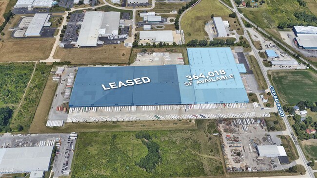
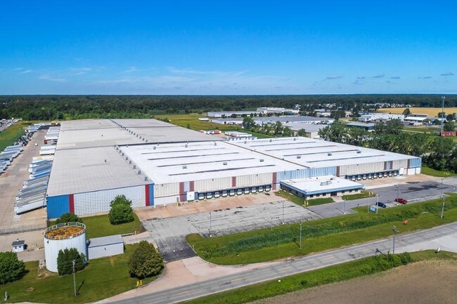
7111 Crabb Rd, Temperance, MI 48182
NEARBY LISTINGS FOR SALE OR LEASE
Property Detail
7111 Crabb Rd
02-035-010-10
S2 NE4 T08S R07E
Officebuilding
Monroe
X
Michigan
39095C0081F
13.97 AC
2025
Monroe County
2025
Detroit
833500
Monroe, MI
302,338 SF
DEMOGRAPHICS near 7111 Crabb Rd
1 Mile
3 Mile
5 Mile
2024 Total Population
3,251
37,057
126,749
2029 Population
3,312
37,203
125,761
Pop Growth 2024-2029
+ 1.88%
+ 0.39%
(0.78%)
Average Age
45
41
40
2024 Total Households
1,403
15,920
53,171
HH Growth 2024-2029
+ 2.00%
+ 0.36%
(0.84%)
Median Household Inc
$49,761
$57,359
$55,997
Avg Household Size
2.20
2.30
2.30
2024 Avg HH Vehicles
2.00
2.00
2.00
Median Home Value
$233,255
$152,184
$128,152
Median Year Built
1999
1971
1957
Nearby Places
Map Layers
Map Styles
 Street
 Aerial
- Restaurants
- Banks
- Shops
- Fitness
- Groceries
PUBLIC TRANSPORTATION
AIRPORT
Eugene F Kranz Toledo Express
DRIVE
WALK
Distance
Eugene F Kranz Toledo Express
47 min
27.8 mi
Freight Ports
Port of Toledo
DRIVE
WALK
Distance
Port of Toledo
27 min
14.0 mi
SALE & LEASE HISTORY
LISTING DATE
SALE/LEASE

Sep 25, 2016
For Lease
Sep 24, 2016
For Sale
Sep 23, 2016
For Sale
Jun 26, 2017
For Lease
Jun 02, 2017
For Sale
Aug 25, 2017
For Sale
Nearby Properties
Address
Land Use
TOTAL SIZE
Lot Size
Zoning
Address
Land Use
TOTAL SIZE
Lot Size
Zoning
1,972,579 SF
76.32 AC
10-IG
Address
Land Use
TOTAL SIZE
Lot Size
Zoning
693,900 SF
76.32 AC
10-IG
Address
Land Use
TOTAL SIZE
Lot Size
Zoning
76.32 AC
10-IG
Address
Land Use
TOTAL SIZE
Lot Size
Zoning
223,900 SF
17.26 AC
Address
Land Use
TOTAL SIZE
Lot Size
Zoning
163,962 SF
10.13 AC
Address
Land Use
TOTAL SIZE
Lot Size
Zoning
90,113 SF
11.83 AC
10-RS6
Address
Land Use
TOTAL SIZE
Lot Size
Zoning
450,000 SF
37.30 AC
Address
Land Use
TOTAL SIZE
Lot Size
Zoning
18.70 AC
Address
Land Use
TOTAL SIZE
Lot Size
Zoning
230,400 SF
18 AC
10-CR
Address
Land Use
TOTAL SIZE
Lot Size
Zoning
6.58 AC
Address
Land Use
TOTAL SIZE
Lot Size
Zoning
Address
Land Use
TOTAL SIZE
Lot Size
Zoning
20.67 AC
10-MX
Address
Land Use
TOTAL SIZE
Lot Size
Zoning
47,600 SF
5.04 AC
Address
Land Use
TOTAL SIZE
Lot Size
Zoning
175,978 SF
10.02 AC
10-IL
Address
Land Use
TOTAL SIZE
Lot Size
Zoning
87,898 SF
9.17 AC
Address
Land Use
TOTAL SIZE
Lot Size
Zoning
170,528 SF
15 AC
Address
Land Use
TOTAL SIZE
Lot Size
Zoning
117,635 SF
5.30 AC
Address
Land Use
TOTAL SIZE
Lot Size
Zoning
90,507 SF
9 AC
10-CRSO
Address
Land Use
TOTAL SIZE
Lot Size
Zoning
106.75 AC
AC = AG
Address
Land Use
TOTAL SIZE
Lot Size
Zoning
75,127 SF
5.86 AC
Address
Land Use
TOTAL SIZE
Lot Size
Zoning
159,798 SF
8.32 AC
10-IL
Address
Land Use
TOTAL SIZE
Lot Size
Zoning
123,258 SF
23.59 AC
Address
Land Use
TOTAL SIZE
Lot Size
Zoning
86.45 AC
10-IG
Address
Land Use
TOTAL SIZE
Lot Size
Zoning
125,840 SF
10.50 AC
Address
Land Use
TOTAL SIZE
Lot Size
Zoning
132,601 SF
14.41 AC
10-MX
Address
Land Use
TOTAL SIZE
Lot Size
Zoning
191,297 SF
28.74 AC
10-CRSO
Address
Land Use
TOTAL SIZE
Lot Size
Zoning
2 AC
10-CR
Address
Land Use
TOTAL SIZE
Lot Size
Zoning
123,295 SF
13.22 AC
10-CR
Address
Land Use
TOTAL SIZE
Lot Size
Zoning
48,427 SF
20.29 AC
The World's #1 Commercial Real Estate Marketplace
Connect with us
© 2025 CoStar Group
The information above has been obtained from sources believed reliable. While we do not doubt its accuracy we have not verified it and make no guarantee, warranty or representation about it. It is your responsibility to independently confirm its accuracy and completeness. Any projections, opinions, assumptions, or estimates used are for example only and do not represent the current or future performance of the property. The value of this transaction to you depends on tax and other factors which should be evaluated by your tax, financial, and legal advisors. You and your advisors should conduct a careful, independent investigation of the property to determine to your satisfaction the suitability of the property for your needs.