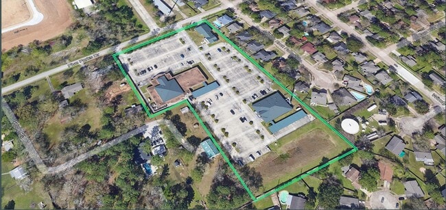
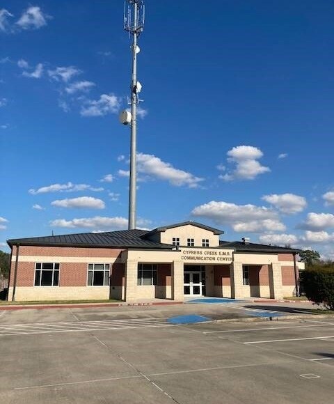
Property Record
7111 Five Forks Dr, Spring, TX 77379

Property Detail
7111 Five Forks Dr
1308260010001
RES A BLK 1 CYPRESS CREEK EMS DISPATCH AND TRAINING CNTR
Publicschool
HARRIS
B and X Area of moderate flood hazard, usually the area between the limits of the 100-year and 500-year floods.
Texas
2024
6.29 AC
2025
FM 1960/Champions
553804
Houston
32,997 SF
Houston-Pasadena-The Woodlands, TX
NEARBY LISTINGS FOR SALE OR LEASE
DEMOGRAPHICS near 7111 Five Forks Dr
1 mile
3 mile
5 mile
2025 Total Population
12,974
97,496
288,290
2030 Population
13,592
103,691
306,831
Pop Growth 2025-2030
+ 4.76%
+ 6.35%
+ 6.43%
Average Age
38
40
38
2025 Total Households
4,368
33,495
101,891
HH Growth 2025-2030
+ 5.01%
+ 6.55%
+ 6.61%
Median Household Inc
$92,385
$105,078
$89,825
Avg Household Size
2.90
2.90
2.80
2025 Avg HH Vehicles
2.00
2.00
2.00
Median Home Value
$338,147
$347,925
$318,314
Median Year Built
1987
1994
1997
Nearby Places
Map Layers
Map Styles
 Street
 Aerial
Transit
 Traffic
 Biking
Places
Listings with unknown addresses are not visible on the map
- Restaurants
- Banks
- Shops
- Fitness
- Groceries
PUBLIC TRANSPORTATION
AIRPORT
George Bush Intcntl/Houston
Drive
Walk
Distance
George Bush Intcntl/Houston
28 min
19.0 mi
Freight Ports
Port of Houston
Drive
Walk
Distance
Port of Houston
48 min
30.1 mi
SALE & LEASE HISTORY
LISTING DATE
SALE/LEASE

Feb 22, 2022
For Sale
Nearby Properties
Address
Land Use
TOTAL SIZE
Lot Size
Zoning
Address
Land Use
TOTAL SIZE
Lot Size
Zoning
341,895 SF
17.53 AC
Address
Land Use
TOTAL SIZE
Lot Size
Zoning
507,035 SF
24.90 AC
Address
Land Use
TOTAL SIZE
Lot Size
Zoning
394,700 SF
17.34 AC
Address
Land Use
TOTAL SIZE
Lot Size
Zoning
322,733 SF
18.40 AC
Address
Land Use
TOTAL SIZE
Lot Size
Zoning
332,688 SF
24.57 AC
Address
Land Use
TOTAL SIZE
Lot Size
Zoning
413,131 SF
12.52 AC
Address
Land Use
TOTAL SIZE
Lot Size
Zoning
267,082 SF
11.13 AC
Address
Land Use
TOTAL SIZE
Lot Size
Zoning
80,004 SF
4.41 AC
Address
Land Use
TOTAL SIZE
Lot Size
Zoning
348,658 SF
16.72 AC
Address
Land Use
TOTAL SIZE
Lot Size
Zoning
148,450 SF
18.26 AC
Address
Land Use
TOTAL SIZE
Lot Size
Zoning
297,961 SF
18.04 AC
Address
Land Use
TOTAL SIZE
Lot Size
Zoning
173,371 SF
5.17 AC
Address
Land Use
TOTAL SIZE
Lot Size
Zoning
222,479 SF
4.82 AC
Address
Land Use
TOTAL SIZE
Lot Size
Zoning
218,967 SF
14.11 AC
Address
Land Use
TOTAL SIZE
Lot Size
Zoning
145,051 SF
6.10 AC
Address
Land Use
TOTAL SIZE
Lot Size
Zoning
214,862 SF
14.92 AC
Address
Land Use
TOTAL SIZE
Lot Size
Zoning
224,669 SF
15.40 AC
Address
Land Use
TOTAL SIZE
Lot Size
Zoning
202,323 SF
9.37 AC
Address
Land Use
TOTAL SIZE
Lot Size
Zoning
148,611 SF
5.84 AC
Address
Land Use
TOTAL SIZE
Lot Size
Zoning
215,011 SF
12.16 AC
Address
Land Use
TOTAL SIZE
Lot Size
Zoning
82,892 SF
8.91 AC
Address
Land Use
TOTAL SIZE
Lot Size
Zoning
167,616 SF
9.18 AC
Address
Land Use
TOTAL SIZE
Lot Size
Zoning
152,390 SF
5.56 AC
Address
Land Use
TOTAL SIZE
Lot Size
Zoning
91,806 SF
4.10 AC
Address
Land Use
TOTAL SIZE
Lot Size
Zoning
157,511 SF
6.30 AC
Address
Land Use
TOTAL SIZE
Lot Size
Zoning
122,558 SF
8.31 AC
Address
Land Use
TOTAL SIZE
Lot Size
Zoning
139,970 SF
6.03 AC
Address
Land Use
TOTAL SIZE
Lot Size
Zoning
118,855 SF
10.19 AC
Address
Land Use
TOTAL SIZE
Lot Size
Zoning
91,365 SF
5.83 AC
Address
Land Use
TOTAL SIZE
Lot Size
Zoning
103,882 SF
4.30 AC
The World's #1 Commercial Real Estate Marketplace
Connect with us
© 2026 CoStar Group
The information above has been obtained from sources believed reliable. While we do not doubt its accuracy we have not verified it and make no guarantee, warranty or representation about it. It is your responsibility to independently confirm its accuracy and completeness. Any projections, opinions, assumptions, or estimates used are for example only and do not represent the current or future performance of the property. The value of this transaction to you depends on tax and other factors which should be evaluated by your tax, financial, and legal advisors. You and your advisors should conduct a careful, independent investigation of the property to determine to your satisfaction the suitability of the property for your needs.