Property Record
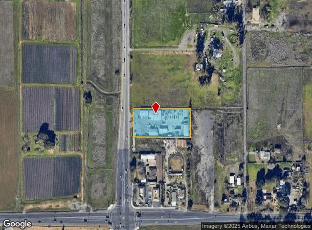
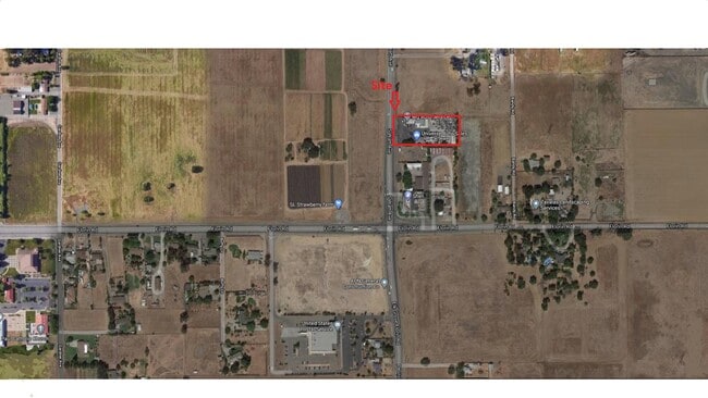
7111 S Watt Ave, Sacramento, CA 95829
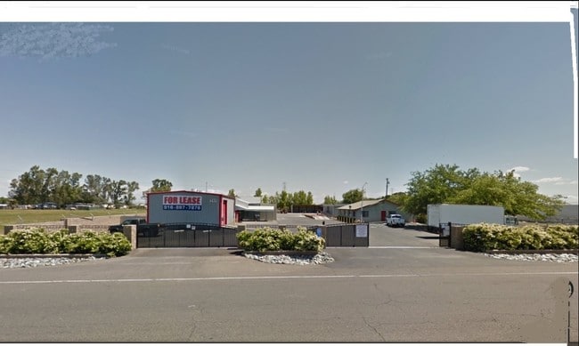

This Property Is For Sale
NEARBY LISTINGS FOR SALE OR LEASE
Property Detail
7111 S Watt Ave
064-0080-056
POR SEC 31, T8N, R6E, MDB&M DES AS BEG AT A PT LOC N00%2700W485 FT FR SW COR OF SD SEC 31; TH N00%2700W 175 FT;
Lightindustrial
Sacramento
X
California
06067C0326H
1.38 AC
2024
Power Inn
2025
Sacramento
009201
Sacramento--Roseville--Arden-Arcade, CA
1,512 SF
DEMOGRAPHICS near 7111 S Watt Ave
1 Mile
3 Mile
5 Mile
2024 Total Population
3,743
84,683
297,826
2029 Population
3,756
85,099
299,639
Pop Growth 2024-2029
+ 0.35%
+ 0.49%
+ 0.61%
Average Age
40
38
37
2024 Total Households
1,282
24,894
94,554
HH Growth 2024-2029
+ 0.16%
+ 0.45%
+ 0.62%
Median Household Inc
$71,210
$74,114
$70,900
Avg Household Size
2.80
3.30
3.00
2024 Avg HH Vehicles
2.00
2.00
2.00
Median Home Value
$342,050
$392,838
$400,331
Median Year Built
1982
1986
1981
Nearby Places
Map Layers
Map Styles
 Street
 Aerial
- Restaurants
- Banks
- Shops
- Fitness
- Groceries
PUBLIC TRANSPORTATION
AIRPORT
Sacramento International
DRIVE
WALK
Distance
Sacramento International
32 min
22.7 mi
Freight Ports
Port of Stockton
DRIVE
WALK
Distance
Port of Stockton
58 min
47.7 mi
Nearby Properties
Address
Land Use
TOTAL SIZE
Lot Size
Zoning
Address
Land Use
TOTAL SIZE
Lot Size
Zoning
7,742 SF
12.66 AC
M-1S-SWR
Address
Land Use
TOTAL SIZE
Lot Size
Zoning
2,317,288 SF
220.58 AC
M-2-SPD
Address
Land Use
TOTAL SIZE
Lot Size
Zoning
45.93 AC
M-2S
Address
Land Use
TOTAL SIZE
Lot Size
Zoning
149,566 SF
9.68 AC
M-2S
Address
Land Use
TOTAL SIZE
Lot Size
Zoning
119,380 SF
18.92 AC
M-2S
Address
Land Use
TOTAL SIZE
Lot Size
Zoning
187,080 SF
10.01 AC
SPA M-1
Address
Land Use
TOTAL SIZE
Lot Size
Zoning
40.67 AC
M-2-SPD
Address
Land Use
TOTAL SIZE
Lot Size
Zoning
584,820 SF
29.12 AC
M-2S
Address
Land Use
TOTAL SIZE
Lot Size
Zoning
198,112 SF
19.62 AC
M-1 M-1 (N
Address
Land Use
TOTAL SIZE
Lot Size
Zoning
7.55 AC
SPA
Address
Land Use
TOTAL SIZE
Lot Size
Zoning
281,404 SF
21.43 AC
M-2
Address
Land Use
TOTAL SIZE
Lot Size
Zoning
261,350 SF
14.41 AC
M-2S
Address
Land Use
TOTAL SIZE
Lot Size
Zoning
319,485 SF
16.35 AC
M-2S
Address
Land Use
TOTAL SIZE
Lot Size
Zoning
158,710 SF
14.02 AC
M-1 (NPA)
Address
Land Use
TOTAL SIZE
Lot Size
Zoning
204,290 SF
11.86 AC
RD-20
Address
Land Use
TOTAL SIZE
Lot Size
Zoning
138,779 SF
44.77 AC
M-2S
Address
Land Use
TOTAL SIZE
Lot Size
Zoning
120,868 SF
53.03 AC
SPA
Address
Land Use
TOTAL SIZE
Lot Size
Zoning
188,144 SF
16.90 AC
M-2S
Address
Land Use
TOTAL SIZE
Lot Size
Zoning
Address
Land Use
TOTAL SIZE
Lot Size
Zoning
55,344 SF
4.75 AC
M-2S
Address
Land Use
TOTAL SIZE
Lot Size
Zoning
143,004 SF
8.81 AC
M-2S
Address
Land Use
TOTAL SIZE
Lot Size
Zoning
12.04 AC
M-1S-R
Address
Land Use
TOTAL SIZE
Lot Size
Zoning
161,834 SF
15.23 AC
LC
Address
Land Use
TOTAL SIZE
Lot Size
Zoning
5.29 AC
M-2S
Address
Land Use
TOTAL SIZE
Lot Size
Zoning
6.90 AC
RD-20
Address
Land Use
TOTAL SIZE
Lot Size
Zoning
447,342 SF
29.41 AC
M-1S-SWR M
Address
Land Use
TOTAL SIZE
Lot Size
Zoning
5,574 SF
10.34 AC
M-2S
Address
Land Use
TOTAL SIZE
Lot Size
Zoning
167,152 SF
7.53 AC
RD-20
Address
Land Use
TOTAL SIZE
Lot Size
Zoning
273,000 SF
14.38 AC
M-1S-SWR
Address
Land Use
TOTAL SIZE
Lot Size
Zoning
75,765 SF
19.04 AC
M-1S-R
The World's #1 Commercial Real Estate Marketplace
Connect with us
© 2025 CoStar Group
The information above has been obtained from sources believed reliable. While we do not doubt its accuracy we have not verified it and make no guarantee, warranty or representation about it. It is your responsibility to independently confirm its accuracy and completeness. Any projections, opinions, assumptions, or estimates used are for example only and do not represent the current or future performance of the property. The value of this transaction to you depends on tax and other factors which should be evaluated by your tax, financial, and legal advisors. You and your advisors should conduct a careful, independent investigation of the property to determine to your satisfaction the suitability of the property for your needs.