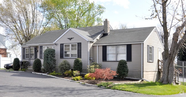
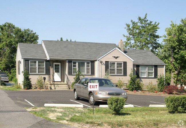
Property Record
7113 Windsor Mill Rd, Windsor Mill, MD 21244
NEARBY LISTINGS FOR SALE OR LEASE
Property Detail
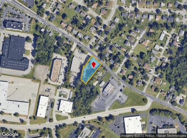
7113 Windsor Mill Rd
02-0219640510
20,737 SQ FT
Officebuilding
Baltimore
X
Maryland
2400100378G
0.48 AC
2024
Woodlawn
2025
Baltimore
402407
Baltimore-Columbia-Towson, MD
1,972 SF
DEMOGRAPHICS near 7113 Windsor Mill Rd
1 Mile
3 Mile
5 Mile
2024 Total Population
16,274
110,461
315,496
2029 Population
16,032
108,357
308,390
Pop Growth 2024-2029
(1.49%)
(1.90%)
(2.25%)
Average Age
40
41
41
2024 Total Households
6,309
42,705
124,400
HH Growth 2024-2029
(1.55%)
(2.02%)
(2.41%)
Median Household Inc
$67,500
$67,588
$67,296
Avg Household Size
2.50
2.50
2.40
2024 Avg HH Vehicles
2.00
2.00
2.00
Median Home Value
$242,672
$246,906
$263,427
Median Year Built
1973
1966
1963
Nearby Places
Map Layers
Map Styles
 Street
 Aerial
- Restaurants
- Banks
- Shops
- Fitness
- Groceries
PUBLIC TRANSPORTATION
COMMUTER RAIL
West Baltimore (Penn Line - Maryland Area Regional Commuter Trains (The MARC))
DRIVE
WALK
Distance
West Baltimore (Penn Line - Maryland Area Regional Commuter Trains (The MARC))
19 min
7.3 mi
Penn Station (Penn Line - Maryland Area Regional Commuter Trains (The MARC))
DRIVE
WALK
Distance
Penn Station (Penn Line - Maryland Area Regional Commuter Trains (The MARC))
23 min
8.6 mi
AIRPORT
Baltimore/Washington International Thurgood Marshall
DRIVE
WALK
Distance
Baltimore/Washington International Thurgood Marshall
25 min
14.0 mi
Ronald Reagan Washington Ntl
DRIVE
WALK
Distance
Ronald Reagan Washington Ntl
73 min
46.2 mi
Freight Ports
Port of Baltimore
DRIVE
WALK
Distance
Port of Baltimore
24 min
9.8 mi
Nearby Properties
Address
Land Use
TOTAL SIZE
Lot Size
Zoning
Address
Land Use
TOTAL SIZE
Lot Size
Zoning
941,727 SF
36.89 AC
TOD-3
Address
Land Use
TOTAL SIZE
Lot Size
Zoning
1,809,709 SF
50 AC
DR3.5
Address
Land Use
TOTAL SIZE
Lot Size
Zoning
883,140 SF
57.77 AC
MLR
Address
Land Use
TOTAL SIZE
Lot Size
Zoning
608,642 SF
56.37 AC
DR3.5
Address
Land Use
TOTAL SIZE
Lot Size
Zoning
271,096 SF
6 AC
02
Address
Land Use
TOTAL SIZE
Lot Size
Zoning
173,057 SF
17.22 AC
Address
Land Use
TOTAL SIZE
Lot Size
Zoning
278,271 SF
55.16 AC
DR5.5
Address
Land Use
TOTAL SIZE
Lot Size
Zoning
233,082 SF
10.98 AC
Address
Land Use
TOTAL SIZE
Lot Size
Zoning
29.11 AC
DR16
Address
Land Use
TOTAL SIZE
Lot Size
Zoning
26.14 AC
DR16
Address
Land Use
TOTAL SIZE
Lot Size
Zoning
27.75 AC
DR16
Address
Land Use
TOTAL SIZE
Lot Size
Zoning
184,320 SF
13.37 AC
DR5.5
Address
Land Use
TOTAL SIZE
Lot Size
Zoning
16.75 AC
MLR02
Address
Land Use
TOTAL SIZE
Lot Size
Zoning
325,203 SF
6.24 AC
DR5.5
Address
Land Use
TOTAL SIZE
Lot Size
Zoning
16.70 AC
Address
Land Use
TOTAL SIZE
Lot Size
Zoning
26.88 AC
DR16
Address
Land Use
TOTAL SIZE
Lot Size
Zoning
29.14 AC
DR16
Address
Land Use
TOTAL SIZE
Lot Size
Zoning
19.10 AC
DR16
Address
Land Use
TOTAL SIZE
Lot Size
Zoning
3,032 SF
87 SF
H
Address
Land Use
TOTAL SIZE
Lot Size
Zoning
14.41 AC
Address
Land Use
TOTAL SIZE
Lot Size
Zoning
118,460 SF
17.85 AC
O2
Address
Land Use
TOTAL SIZE
Lot Size
Zoning
22.99 AC
DR16
Address
Land Use
TOTAL SIZE
Lot Size
Zoning
194,844 SF
14.33 AC
ML
Address
Land Use
TOTAL SIZE
Lot Size
Zoning
19.35 AC
DR16
Address
Land Use
TOTAL SIZE
Lot Size
Zoning
12.07 AC
DR16
Address
Land Use
TOTAL SIZE
Lot Size
Zoning
140,286 SF
11.71 AC
BR
Address
Land Use
TOTAL SIZE
Lot Size
Zoning
13.68 AC
DR16
Address
Land Use
TOTAL SIZE
Lot Size
Zoning
162,386 SF
30.68 AC
DR5.5
Address
Land Use
TOTAL SIZE
Lot Size
Zoning
116,645 SF
9.86 AC
Address
Land Use
TOTAL SIZE
Lot Size
Zoning
12.69 AC
DR16
The World's #1 Commercial Real Estate Marketplace
Connect with us
© 2026 CoStar Group
The information above has been obtained from sources believed reliable. While we do not doubt its accuracy we have not verified it and make no guarantee, warranty or representation about it. It is your responsibility to independently confirm its accuracy and completeness. Any projections, opinions, assumptions, or estimates used are for example only and do not represent the current or future performance of the property. The value of this transaction to you depends on tax and other factors which should be evaluated by your tax, financial, and legal advisors. You and your advisors should conduct a careful, independent investigation of the property to determine to your satisfaction the suitability of the property for your needs.