Property Record
7115 Mc Cracken Rd, Westley, CA 95387
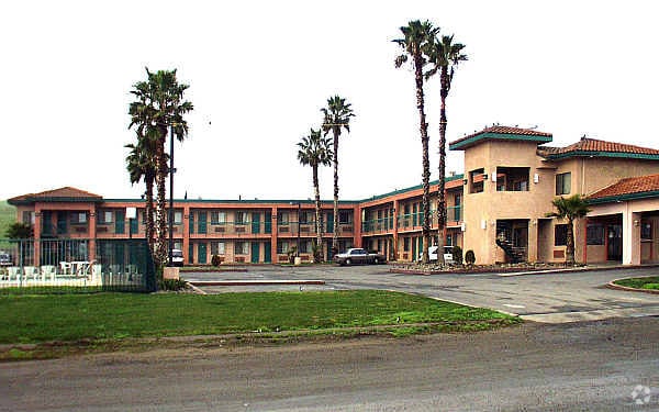


Property Detail
7115 Mc Cracken Rd
016-36-15
STANISLAUS
Hotel
California
B and X Area of moderate flood hazard, usually the area between the limits of the 100-year and 500-year floods.
a
2025
2 AC
2025
Stockton/Modesto
003300
Stockton/Modesto
10,780 SF
Modesto, CA
NEARBY LISTINGS FOR SALE OR LEASE
-
-
View all Westley listings for sale on LoopNet.com
DEMOGRAPHICS near 7115 Mc Cracken Rd
1 mile
3 mile
5 mile
2025 Total Population
0
9
313
2030 Population
0
9
302
Pop Growth 2025-2030
0.00%
0.00%
(3.51%)
Average Age
0
32
37
2025 Total Households
0
3
96
HH Growth 2025-2030
0.00%
0.00%
(3.13%)
Median Household Inc
$0
$87,500
$89,999
Avg Household Size
.00
2.50
3.30
2025 Avg HH Vehicles
.00
2.00
3.00
Median Home Value
$0
$499,999
$590,909
Median Year Built
0
2002
1999
Nearby Places
Map Layers
Map Styles
 Street
 Aerial
Layers
 Traffic
 Biking
Places
Listings with unknown addresses are not visible on the map
- Restaurants
- Banks
- Shops
- Fitness
- Groceries
PUBLIC TRANSPORTATION
AIRPORT
Stockton Metro
Drive
Walk
Distance
Stockton Metro
36 min
30.5 mi
Freight Ports
Port of Stockton
Drive
Walk
Distance
Port of Stockton
39 min
33.8 mi
SALE & LEASE HISTORY
LISTING DATE
SALE/LEASE

Feb 22, 2023
For Sale
Feb 21, 2024
For Sale
Nearby Properties
Address
Land Use
TOTAL SIZE
Lot Size
Zoning
Address
Land Use
TOTAL SIZE
Lot Size
Zoning
25,625 SF
11.80 AC
PC
Address
Land Use
TOTAL SIZE
Lot Size
Zoning
10,269 SF
2.24 AC
COUPD
Address
Land Use
TOTAL SIZE
Lot Size
Zoning
6,276 SF
430 AC
Address
Land Use
TOTAL SIZE
Lot Size
Zoning
11,952 SF
2 AC
Address
Land Use
TOTAL SIZE
Lot Size
Zoning
4,370 SF
10 AC
Address
Land Use
TOTAL SIZE
Lot Size
Zoning
83.93 AC
Address
Land Use
TOTAL SIZE
Lot Size
Zoning
1,192 SF
252.50 AC
A340
Address
Land Use
TOTAL SIZE
Lot Size
Zoning
3,017 SF
1.94 AC
Address
Land Use
TOTAL SIZE
Lot Size
Zoning
280,000 SF
52.11 AC
A340
Address
Land Use
TOTAL SIZE
Lot Size
Zoning
4,178 SF
1.21 AC
Address
Land Use
TOTAL SIZE
Lot Size
Zoning
59.56 AC
A240
Address
Land Use
TOTAL SIZE
Lot Size
Zoning
209.69 AC
Address
Land Use
TOTAL SIZE
Lot Size
Zoning
130 AC
A240
Address
Land Use
TOTAL SIZE
Lot Size
Zoning
1,752 SF
50 AC
A240
Address
Land Use
TOTAL SIZE
Lot Size
Zoning
Address
Land Use
TOTAL SIZE
Lot Size
Zoning
4,038 SF
67.60 AC
A240
Address
Land Use
TOTAL SIZE
Lot Size
Zoning
112 AC
Address
Land Use
TOTAL SIZE
Lot Size
Zoning
105.30 AC
Address
Land Use
TOTAL SIZE
Lot Size
Zoning
1,882 SF
94.39 AC
A240
Address
Land Use
TOTAL SIZE
Lot Size
Zoning
Address
Land Use
TOTAL SIZE
Lot Size
Zoning
Address
Land Use
TOTAL SIZE
Lot Size
Zoning
97.10 AC
Address
Land Use
TOTAL SIZE
Lot Size
Zoning
185.87 AC
Address
Land Use
TOTAL SIZE
Lot Size
Zoning
712 SF
178.72 AC
A240
Address
Land Use
TOTAL SIZE
Lot Size
Zoning
816 SF
162.71 AC
A340
Address
Land Use
TOTAL SIZE
Lot Size
Zoning
66.41 AC
Address
Land Use
TOTAL SIZE
Lot Size
Zoning
60.81 AC
Address
Land Use
TOTAL SIZE
Lot Size
Zoning
141.50 AC
A240
Address
Land Use
TOTAL SIZE
Lot Size
Zoning
40.50 AC
The World's #1 Commercial Real Estate Marketplace
Connect with us
© 2026 CoStar Group
The information above has been obtained from sources believed reliable. While we do not doubt its accuracy we have not verified it and make no guarantee, warranty or representation about it. It is your responsibility to independently confirm its accuracy and completeness. Any projections, opinions, assumptions, or estimates used are for example only and do not represent the current or future performance of the property. The value of this transaction to you depends on tax and other factors which should be evaluated by your tax, financial, and legal advisors. You and your advisors should conduct a careful, independent investigation of the property to determine to your satisfaction the suitability of the property for your needs.