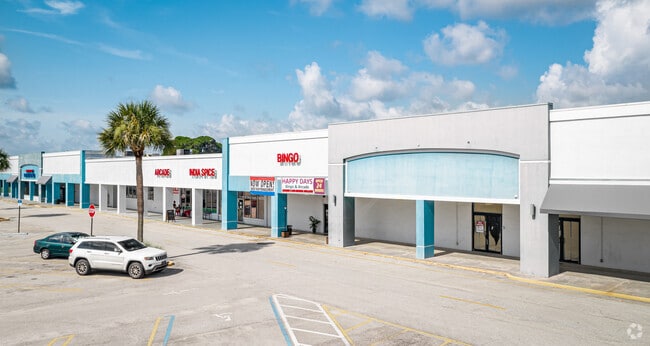
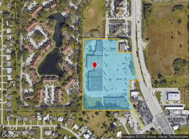
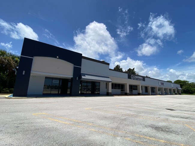
Property Record
7115 S Us Highway 1, Port Saint Lucie, FL 34952
Current Lease Availabilities
General Retail LEASE
$12.00 - $14.00 SF/YR
8,300 - 21,126 SF
NEARBY LISTINGS FOR SALE OR LEASE
Property Detail
7115 S Us Highway 1
34-22-211-0010-0006
Metes And Bounds
Regionalshoppingcenterormallwithanchorstore
22 36 40 BEG AT SE COR OF NE 1/4 OF NW 1/4 RUN S 27 DEG 38 MIN E 210 FT TO N LI OF RIO MAR DR, TH S 62 DEG 22 MIN W 30 FT, TH N 27 DEG 38 MIN W 225.83 FT, TH N 89 DEG 49 MIN W 555.72 FT M/L, TH N 00 DEG 07 MIN E 800 FT, TH S 89 DEG 49 MIN E 400 FT, T
X
St Lucie
12111C0279K
Florida
2024
9.96 AC
2025
Port St Lucie
381802
Port St Lucie/Fort Pierce
93,988 SF
Port St Lucie, FL
DEMOGRAPHICS near 7115 S Us Highway 1
1 Mile
3 Mile
5 Mile
2024 Total Population
5,361
55,648
137,928
2029 Population
6,443
66,664
165,699
Pop Growth 2024-2029
+ 20.18%
+ 19.80%
+ 20.13%
Average Age
45
44
43
2024 Total Households
2,447
22,298
54,284
HH Growth 2024-2029
+ 19.62%
+ 19.39%
+ 19.77%
Median Household Inc
$58,543
$56,128
$60,962
Avg Household Size
2.20
2.40
2.50
2024 Avg HH Vehicles
2.00
2.00
2.00
Median Home Value
$227,765
$231,034
$248,527
Median Year Built
1992
1988
1993
Nearby Places
- Restaurants
- Banks
- Shops
- Fitness
- Groceries
Nearby Properties
Address
Land Use
TOTAL SIZE
Lot Size
Zoning
Address
Land Use
TOTAL SIZE
Lot Size
Zoning
230,294 SF
40.59 AC
Address
Land Use
TOTAL SIZE
Lot Size
Zoning
117,007 SF
31.76 AC
RM-5 - COU
Address
Land Use
TOTAL SIZE
Lot Size
Zoning
136,270 SF
49.75 AC
RM-9 COUNT
Address
Land Use
TOTAL SIZE
Lot Size
Zoning
54,810 SF
10.14 AC
GENERAL CO
Address
Land Use
TOTAL SIZE
Lot Size
Zoning
112,457 SF
22.73 AC
PUD
Address
Land Use
TOTAL SIZE
Lot Size
Zoning
88,317 SF
34.81 AC
RM-5 - COU
Address
Land Use
TOTAL SIZE
Lot Size
Zoning
106,711 SF
16.73 AC
PUD
Address
Land Use
TOTAL SIZE
Lot Size
Zoning
112,014 SF
18.15 AC
GENERAL CO
Address
Land Use
TOTAL SIZE
Lot Size
Zoning
176,981 SF
27.58 AC
INSTITUTIO
Address
Land Use
TOTAL SIZE
Lot Size
Zoning
73,609 SF
16.96 AC
Address
Land Use
TOTAL SIZE
Lot Size
Zoning
82,896 SF
8.48 AC
COMM GENRA
Address
Land Use
TOTAL SIZE
Lot Size
Zoning
42,801 SF
2.39 AC
CS SERVIC
Address
Land Use
TOTAL SIZE
Lot Size
Zoning
47,154 SF
19.96 AC
RM-5 - COU
Address
Land Use
TOTAL SIZE
Lot Size
Zoning
53,326 SF
4.85 AC
COMM GENRA
Address
Land Use
TOTAL SIZE
Lot Size
Zoning
66,333 SF
9.88 AC
PUD
Address
Land Use
TOTAL SIZE
Lot Size
Zoning
79,484 SF
26.63 AC
Address
Land Use
TOTAL SIZE
Lot Size
Zoning
155,994 SF
25.13 AC
Address
Land Use
TOTAL SIZE
Lot Size
Zoning
48,561 SF
9.42 AC
COMM GENRA
Address
Land Use
TOTAL SIZE
Lot Size
Zoning
67,518 SF
27.60 AC
INSTITUTIO
Address
Land Use
TOTAL SIZE
Lot Size
Zoning
31,078 SF
7.92 AC
GENERAL CO
Address
Land Use
TOTAL SIZE
Lot Size
Zoning
106,188 SF
10.87 AC
GENERAL CO
Address
Land Use
TOTAL SIZE
Lot Size
Zoning
45,639 SF
6.96 AC
GENERAL CO
Address
Land Use
TOTAL SIZE
Lot Size
Zoning
93,280 SF
13.70 AC
COMM GENRA
Address
Land Use
TOTAL SIZE
Lot Size
Zoning
22,494 SF
7.05 AC
GENERAL CO
Address
Land Use
TOTAL SIZE
Lot Size
Zoning
96,600 SF
5.05 AC
COMM GENRA
Address
Land Use
TOTAL SIZE
Lot Size
Zoning
93,222 SF
27.10 AC
U-PSL
Address
Land Use
TOTAL SIZE
Lot Size
Zoning
38,273 SF
7.65 AC
GENERAL CO
Address
Land Use
TOTAL SIZE
Lot Size
Zoning
30,926 SF
1.04 AC
CS SERVIC
Address
Land Use
TOTAL SIZE
Lot Size
Zoning
87,827 SF
4.15 AC
COMM GENRA
The World's #1 Commercial Real Estate Marketplace
Connect with us
© 2025 CoStar Group
The information above has been obtained from sources believed reliable. While we do not doubt its accuracy we have not verified it and make no guarantee, warranty or representation about it. It is your responsibility to independently confirm its accuracy and completeness. Any projections, opinions, assumptions, or estimates used are for example only and do not represent the current or future performance of the property. The value of this transaction to you depends on tax and other factors which should be evaluated by your tax, financial, and legal advisors. You and your advisors should conduct a careful, independent investigation of the property to determine to your satisfaction the suitability of the property for your needs.