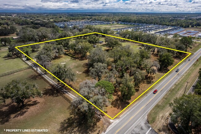
Property Record
7115 Sw 80Th Ave, Ocala, FL 34481


NEARBY LISTINGS FOR SALE OR LEASE
Property Detail
7115 Sw 80Th Ave
35467-000-01
SEC 07 TWP 16 RGE 21 SW 1/4 OF SW 1/4 OF NW 1/4 DESC AS: BEGIN AT THE SW COR OF NW 1/4 OF SEC 7 TH N 00-16-05 E 660.63 FT TH S 89-58-37 E 748.13 FT TH S 00-08-46 W 660.98 FT TH N 89-58-36 W 749.54 FT TO THE POB EXC S 20 FT THEREOF
Pasture
Marion
X
Florida
12083C0682E
10.71 AC
2024
Outlying Marion County
2024
Ocala
002505
Ocala, FL
2,470 SF
DEMOGRAPHICS near 7115 Sw 80Th Ave
1 Mile
3 Mile
5 Mile
2024 Total Population
2,574
28,700
67,594
2029 Population
3,432
37,800
88,623
Pop Growth 2024-2029
+ 33.33%
+ 31.71%
+ 31.11%
Average Age
52
61
54
2024 Total Households
1,160
14,584
32,045
HH Growth 2024-2029
+ 33.79%
+ 32.06%
+ 31.47%
Median Household Inc
$56,379
$56,214
$58,971
Avg Household Size
2.20
1.90
2.10
2024 Avg HH Vehicles
2.00
1.00
2.00
Median Home Value
$231,982
$217,690
$211,264
Median Year Built
2005
2002
1999
Nearby Places
Map Layers
Map Styles
 Street
 Aerial
- Restaurants
- Banks
- Shops
- Fitness
- Groceries
SALE & LEASE HISTORY
LISTING DATE
SALE/LEASE

May 22, 2025
For Lease
Nearby Properties
Address
Land Use
TOTAL SIZE
Lot Size
Zoning
Address
Land Use
TOTAL SIZE
Lot Size
Zoning
189,662 SF
25.54 AC
B2
Address
Land Use
TOTAL SIZE
Lot Size
Zoning
155,077 SF
40.05 AC
PUD
Address
Land Use
TOTAL SIZE
Lot Size
Zoning
322,193 SF
70.13 AC
INST
Address
Land Use
TOTAL SIZE
Lot Size
Zoning
96,094 SF
13.66 AC
B2
Address
Land Use
TOTAL SIZE
Lot Size
Zoning
62,253 SF
6.52 AC
PUD
Address
Land Use
TOTAL SIZE
Lot Size
Zoning
74,928 SF
7.80 AC
PUD
Address
Land Use
TOTAL SIZE
Lot Size
Zoning
95,496 SF
25.25 AC
R3
Address
Land Use
TOTAL SIZE
Lot Size
Zoning
18,035 SF
3.33 AC
B2
Address
Land Use
TOTAL SIZE
Lot Size
Zoning
55,985 SF
21.78 AC
B4
Address
Land Use
TOTAL SIZE
Lot Size
Zoning
139,728 SF
22.86 AC
B4
Address
Land Use
TOTAL SIZE
Lot Size
Zoning
84,004 SF
9.77 AC
SC
Address
Land Use
TOTAL SIZE
Lot Size
Zoning
65,060 SF
11.90 AC
B2
Address
Land Use
TOTAL SIZE
Lot Size
Zoning
98,205 SF
13.41 AC
B2
Address
Land Use
TOTAL SIZE
Lot Size
Zoning
42,673 SF
13.72 AC
A1
Address
Land Use
TOTAL SIZE
Lot Size
Zoning
42,159 SF
5.95 AC
B2
Address
Land Use
TOTAL SIZE
Lot Size
Zoning
48,518 SF
84.49 AC
A1
Address
Land Use
TOTAL SIZE
Lot Size
Zoning
47,600 SF
735.53 AC
PD
Address
Land Use
TOTAL SIZE
Lot Size
Zoning
99,045 SF
7.19 AC
B2
Address
Land Use
TOTAL SIZE
Lot Size
Zoning
82,465 SF
6.13 AC
B2
Address
Land Use
TOTAL SIZE
Lot Size
Zoning
47,378 SF
23.26 AC
A1
Address
Land Use
TOTAL SIZE
Lot Size
Zoning
286.80 AC
PUD
Address
Land Use
TOTAL SIZE
Lot Size
Zoning
58,381 SF
5.12 AC
R3
Address
Land Use
TOTAL SIZE
Lot Size
Zoning
13,943 SF
0.43 AC
B2
Address
Land Use
TOTAL SIZE
Lot Size
Zoning
25,128 SF
4.38 AC
PD
Address
Land Use
TOTAL SIZE
Lot Size
Zoning
16,214 SF
4.91 AC
B2
Address
Land Use
TOTAL SIZE
Lot Size
Zoning
27,862 SF
17.04 AC
A1
Address
Land Use
TOTAL SIZE
Lot Size
Zoning
38,062 SF
3.07 AC
B2
Address
Land Use
TOTAL SIZE
Lot Size
Zoning
31,182 SF
7.07 AC
GU
Address
Land Use
TOTAL SIZE
Lot Size
Zoning
35,280 SF
4.02 AC
B2
The World's #1 Commercial Real Estate Marketplace
Connect with us
© 2025 CoStar Group
The information above has been obtained from sources believed reliable. While we do not doubt its accuracy we have not verified it and make no guarantee, warranty or representation about it. It is your responsibility to independently confirm its accuracy and completeness. Any projections, opinions, assumptions, or estimates used are for example only and do not represent the current or future performance of the property. The value of this transaction to you depends on tax and other factors which should be evaluated by your tax, financial, and legal advisors. You and your advisors should conduct a careful, independent investigation of the property to determine to your satisfaction the suitability of the property for your needs.