Property Record
7116 Choctaw Ct, Browns Summit, NC 27214
Property Detail
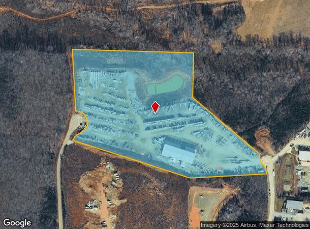
7116 Choctaw Ct
0128107
3 LOTS COMBINED 6 - 8 PL:158-122
Industrialgeneral
GUILFORD
HI
North Carolina
B and X Area of moderate flood hazard, usually the area between the limits of the 100-year and 500-year floods.
94
2024
14.26 AC
2025
NE Guilford County
015602
Greensboro/Winston-Salem
15,180 SF
Greensboro-High Point, NC
NEARBY LISTINGS FOR SALE OR LEASE
DEMOGRAPHICS near 7116 Choctaw Ct
1 mile
3 mile
5 mile
2025 Total Population
1,536
10,635
34,395
2030 Population
1,642
11,182
35,898
Pop Growth 2025-2030
+ 6.90%
+ 5.14%
+ 4.37%
Average Age
36
39
39
2025 Total Households
523
3,906
12,492
HH Growth 2025-2030
+ 7.27%
+ 5.22%
+ 4.48%
Median Household Inc
$73,775
$85,420
$78,868
Avg Household Size
2.80
2.60
2.70
2025 Avg HH Vehicles
2.00
2.00
2.00
Median Home Value
$278,312
$262,836
$272,769
Median Year Built
2004
2001
1998
Nearby Places
Map Layers
Map Styles
 Street
 Aerial
Layers
 Traffic
 Biking
Places
Listings with unknown addresses are not visible on the map
- Restaurants
- Banks
- Shops
- Fitness
- Groceries
PUBLIC TRANSPORTATION
AIRPORT
Piedmont Triad International
Drive
Walk
Distance
Piedmont Triad International
32 min
18.9 mi
Freight Ports
Virginia Port Authority - Richmond
Drive
Walk
Distance
Virginia Port Authority - Richmond
229 min
176.3 mi
Nearby Properties
Address
Land Use
TOTAL SIZE
Lot Size
Zoning
Address
Land Use
TOTAL SIZE
Lot Size
Zoning
1,587,604 SF
285.58 AC
HI
Address
Land Use
TOTAL SIZE
Lot Size
Zoning
807,600 SF
93.09 AC
PUD
Address
Land Use
TOTAL SIZE
Lot Size
Zoning
500,160 SF
52.97 AC
LI
Address
Land Use
TOTAL SIZE
Lot Size
Zoning
504,000 SF
42.01 AC
HI
Address
Land Use
TOTAL SIZE
Lot Size
Zoning
584,848 SF
32.91 AC
HI
Address
Land Use
TOTAL SIZE
Lot Size
Zoning
25,679 SF
366.35 AC
PI
Address
Land Use
TOTAL SIZE
Lot Size
Zoning
236,322 SF
19.64 AC
HI
Address
Land Use
TOTAL SIZE
Lot Size
Zoning
257,713 SF
24.07 AC
HI
Address
Land Use
TOTAL SIZE
Lot Size
Zoning
243,880 SF
29.56 AC
HI
Address
Land Use
TOTAL SIZE
Lot Size
Zoning
84,289 SF
18.36 AC
PUD
Address
Land Use
TOTAL SIZE
Lot Size
Zoning
218,130 SF
49.82 AC
HI
Address
Land Use
TOTAL SIZE
Lot Size
Zoning
87,514 SF
47.09 AC
AG
Address
Land Use
TOTAL SIZE
Lot Size
Zoning
94,412 SF
11.58 AC
HI
Address
Land Use
TOTAL SIZE
Lot Size
Zoning
87,592 SF
11.95 AC
LI
Address
Land Use
TOTAL SIZE
Lot Size
Zoning
138,573 SF
74.67 AC
PI
Address
Land Use
TOTAL SIZE
Lot Size
Zoning
29,540 SF
6.54 AC
C-L
Address
Land Use
TOTAL SIZE
Lot Size
Zoning
156.66 AC
HI
Address
Land Use
TOTAL SIZE
Lot Size
Zoning
66,661 SF
19.83 AC
PI
Address
Land Use
TOTAL SIZE
Lot Size
Zoning
784 SF
263.60 AC
R-3
Address
Land Use
TOTAL SIZE
Lot Size
Zoning
5,960 SF
121.18 AC
PI
Address
Land Use
TOTAL SIZE
Lot Size
Zoning
72,100 SF
8.25 AC
HI
Address
Land Use
TOTAL SIZE
Lot Size
Zoning
83,696 SF
7.08 AC
HI
Address
Land Use
TOTAL SIZE
Lot Size
Zoning
476.23 AC
CU-GB
Address
Land Use
TOTAL SIZE
Lot Size
Zoning
28,810 SF
181.26 AC
R-3
Address
Land Use
TOTAL SIZE
Lot Size
Zoning
76,860 SF
3.06 AC
HI
Address
Land Use
TOTAL SIZE
Lot Size
Zoning
526.03 AC
R-3
Address
Land Use
TOTAL SIZE
Lot Size
Zoning
97,368 SF
6.40 AC
LI
Address
Land Use
TOTAL SIZE
Lot Size
Zoning
53,097 SF
118.96 AC
PI
Address
Land Use
TOTAL SIZE
Lot Size
Zoning
6,556 SF
6.37 AC
C-M
Address
Land Use
TOTAL SIZE
Lot Size
Zoning
52,766 SF
8.40 AC
HI
The World's #1 Commercial Real Estate Marketplace
Connect with us
© 2026 CoStar Group
The information above has been obtained from sources believed reliable. While we do not doubt its accuracy we have not verified it and make no guarantee, warranty or representation about it. It is your responsibility to independently confirm its accuracy and completeness. Any projections, opinions, assumptions, or estimates used are for example only and do not represent the current or future performance of the property. The value of this transaction to you depends on tax and other factors which should be evaluated by your tax, financial, and legal advisors. You and your advisors should conduct a careful, independent investigation of the property to determine to your satisfaction the suitability of the property for your needs.