Property Record
7117 Crane Ave, Jacksonville, FL 32216

This Property Is For Sale
NEARBY LISTINGS FOR SALE OR LEASE
Property Detail
7117 Crane Ave
136166-0000
Section Land
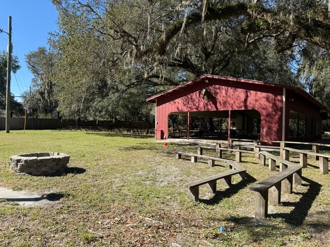
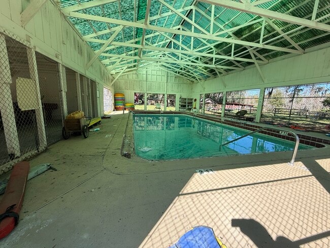
Daycare
50-2S-27E 7.152 PT JOHN B RICHARD GRANT & PT F RICHARD GRANT RECD O/R 17957-994 BEING PARCELS A,B,C
AE
Duval
12031C0387J
Florida
2025
8.51 AC
2026
Southside
015803
Jacksonville (Florida)
19,532 SF
Jacksonville, FL
DEMOGRAPHICS near 7117 Crane Ave
1 Mile
3 Mile
5 Mile
2024 Total Population
13,354
97,890
243,457
2029 Population
14,676
108,189
269,233
Pop Growth 2024-2029
+ 9.90%
+ 10.52%
+ 10.59%
Average Age
38
38
38
2024 Total Households
5,730
39,936
99,914
HH Growth 2024-2029
+ 10.38%
+ 10.99%
+ 11.22%
Median Household Inc
$59,786
$55,566
$61,269
Avg Household Size
2.30
2.40
2.30
2024 Avg HH Vehicles
2.00
2.00
2.00
Median Home Value
$275,345
$258,477
$277,189
Median Year Built
1976
1972
1979
Nearby Places
Map Layers
Map Styles
 Street
 Aerial
- Restaurants
- Banks
- Shops
- Fitness
- Groceries
PUBLIC TRANSPORTATION
AIRPORT
Jacksonville International
DRIVE
WALK
Distance
Jacksonville International
30 min
19.8 mi
Freight Ports
Jacksonville Port
DRIVE
WALK
Distance
Jacksonville Port
15 min
7.3 mi
Nearby Properties
Address
Land Use
TOTAL SIZE
Lot Size
Zoning
Address
Land Use
TOTAL SIZE
Lot Size
Zoning
875,866 SF
22.33 AC
PBF-3
Address
Land Use
TOTAL SIZE
Lot Size
Zoning
565,202 SF
33.92 AC
RMD-D
Address
Land Use
TOTAL SIZE
Lot Size
Zoning
327,165 SF
25 AC
RMD-D
Address
Land Use
TOTAL SIZE
Lot Size
Zoning
203,763 SF
9.97 AC
PUD
Address
Land Use
TOTAL SIZE
Lot Size
Zoning
430,668 SF
27.20 AC
RMD-D
Address
Land Use
TOTAL SIZE
Lot Size
Zoning
323,318 SF
19.24 AC
PUD
Address
Land Use
TOTAL SIZE
Lot Size
Zoning
321,335 SF
19.83 AC
RMD-D
Address
Land Use
TOTAL SIZE
Lot Size
Zoning
410,225 SF
22.11 AC
PUD
Address
Land Use
TOTAL SIZE
Lot Size
Zoning
93,059 SF
8.54 AC
CCG-2
Address
Land Use
TOTAL SIZE
Lot Size
Zoning
302,406 SF
20.54 AC
RMD-D
Address
Land Use
TOTAL SIZE
Lot Size
Zoning
300,360 SF
14.44 AC
RMD-C
Address
Land Use
TOTAL SIZE
Lot Size
Zoning
232,520 SF
12.37 AC
RMD-D
Address
Land Use
TOTAL SIZE
Lot Size
Zoning
210,913 SF
10.32 AC
PUD
Address
Land Use
TOTAL SIZE
Lot Size
Zoning
225,282 SF
15.36 AC
RMD-D
Address
Land Use
TOTAL SIZE
Lot Size
Zoning
266,156 SF
11.54 AC
RMD-D
Address
Land Use
TOTAL SIZE
Lot Size
Zoning
275,005 SF
28.48 AC
PUD
Address
Land Use
TOTAL SIZE
Lot Size
Zoning
172,591 SF
8.40 AC
CRO
Address
Land Use
TOTAL SIZE
Lot Size
Zoning
164,330 SF
9.04 AC
PUD
Address
Land Use
TOTAL SIZE
Lot Size
Zoning
150,073 SF
11.23 AC
CCG-1
Address
Land Use
TOTAL SIZE
Lot Size
Zoning
125,088 SF
6.62 AC
RMD-D
Address
Land Use
TOTAL SIZE
Lot Size
Zoning
245,531 SF
17.37 AC
CCG-1
Address
Land Use
TOTAL SIZE
Lot Size
Zoning
182,393 SF
8.60 AC
RMD-D
Address
Land Use
TOTAL SIZE
Lot Size
Zoning
279,857 SF
12.71 AC
RMD-D
Address
Land Use
TOTAL SIZE
Lot Size
Zoning
180,180 SF
11.06 AC
CRO
Address
Land Use
TOTAL SIZE
Lot Size
Zoning
116,814 SF
11.77 AC
RMD-D
Address
Land Use
TOTAL SIZE
Lot Size
Zoning
211,429 SF
18.27 AC
PUD
Address
Land Use
TOTAL SIZE
Lot Size
Zoning
60,464 SF
8.13 AC
CCG-2
Address
Land Use
TOTAL SIZE
Lot Size
Zoning
180,528 SF
10.57 AC
RMD-D
Address
Land Use
TOTAL SIZE
Lot Size
Zoning
107,850 SF
14.39 AC
PBF-2
Address
Land Use
TOTAL SIZE
Lot Size
Zoning
155,310 SF
8.57 AC
RMD-D
The World's #1 Commercial Real Estate Marketplace
Connect with us
© 2026 CoStar Group
The information above has been obtained from sources believed reliable. While we do not doubt its accuracy we have not verified it and make no guarantee, warranty or representation about it. It is your responsibility to independently confirm its accuracy and completeness. Any projections, opinions, assumptions, or estimates used are for example only and do not represent the current or future performance of the property. The value of this transaction to you depends on tax and other factors which should be evaluated by your tax, financial, and legal advisors. You and your advisors should conduct a careful, independent investigation of the property to determine to your satisfaction the suitability of the property for your needs.