Property Record
7118 Bertner Ave, Houston, TX 77030


Current Lease Availabilities
Property Detail
7118 Bertner Ave
1372750010001
RES A BLK 1 BLOSSOM HOTEL & SUITES 2 R/P
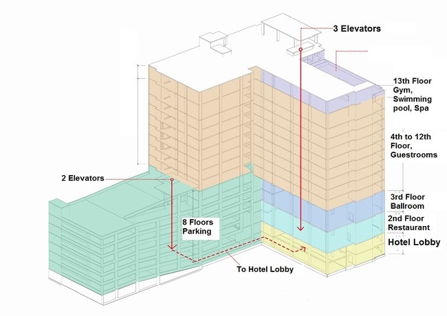
Hotel
Harris
C and X Area of minimal flood hazard, usually depicted on FIRMs as above the 500-year flood level.
Texas
2024
0.92 AC
2025
Houston Medical Ctr/NRG Stadium
314001
Houston
380,761 SF
Houston-Pasadena-The Woodlands, TX
NEARBY LISTINGS FOR SALE OR LEASE
DEMOGRAPHICS near 7118 Bertner Ave
1 mile
3 mile
5 mile
2025 Total Population
24,107
182,856
476,904
2030 Population
26,095
197,685
515,452
Pop Growth 2025-2030
+ 8.25%
+ 8.11%
+ 8.08%
Average Age
34
38
38
2025 Total Households
12,324
86,195
219,247
HH Growth 2025-2030
+ 8.84%
+ 8.47%
+ 8.57%
Median Household Inc
$66,052
$74,742
$82,348
Avg Household Size
1.80
2.00
2.00
2025 Avg HH Vehicles
1.00
1.00
1.00
Median Home Value
$315,507
$580,558
$466,862
Median Year Built
1991
1992
1994
Nearby Places
Map Layers
Map Styles
 Street
 Aerial
Layers
 Traffic
 Biking
Places
Listings with unknown addresses are not visible on the map
- Restaurants
- Banks
- Shops
- Fitness
- Groceries
PUBLIC TRANSPORTATION
TRANSIT/SUBWAY
Texas Medical Center Transit Center (METRORAIL RED LINE - Metropolitan Transit Authority of Harris County)
Drive
Walk
Distance
Texas Medical Center Transit Center (METRORAIL RED LINE - Metropolitan Transit Authority of Harris County)
3 min
9 min
0.5 mi
Smith Lands Stn Sb (METRORAIL RED LINE - Metropolitan Transit Authority of Harris County)
Drive
Walk
Distance
Smith Lands Stn Sb (METRORAIL RED LINE - Metropolitan Transit Authority of Harris County)
2 min
14 min
0.7 mi
Dryden/Tmc Stn Sb (METRORAIL RED LINE - Metropolitan Transit Authority of Harris County)
Drive
Walk
Distance
Dryden/Tmc Stn Sb (METRORAIL RED LINE - Metropolitan Transit Authority of Harris County)
2 min
15 min
0.8 mi
Dryden/Tmc Stn Nb (METRORAIL RED LINE - Metropolitan Transit Authority of Harris County)
Drive
Walk
Distance
Dryden/Tmc Stn Nb (METRORAIL RED LINE - Metropolitan Transit Authority of Harris County)
2 min
16 min
0.8 mi
COMMUTER RAIL
Houston (Sunset Limited - Amtrak)
Drive
Walk
Distance
Houston (Sunset Limited - Amtrak)
13 min
7.2 mi
AIRPORT
William P Hobby
Drive
Walk
Distance
William P Hobby
24 min
11.5 mi
George Bush Intcntl/Houston
Drive
Walk
Distance
George Bush Intcntl/Houston
33 min
24.5 mi
Freight Ports
Port of Houston
Drive
Walk
Distance
Port of Houston
21 min
13.5 mi
Nearby Properties
Address
Land Use
TOTAL SIZE
Lot Size
Zoning
Address
Land Use
TOTAL SIZE
Lot Size
Zoning
519,409 SF
1.52 AC
Address
Land Use
TOTAL SIZE
Lot Size
Zoning
1,252,274 SF
2.02 AC
Address
Land Use
TOTAL SIZE
Lot Size
Zoning
1,880,742 SF
20.77 AC
Address
Land Use
TOTAL SIZE
Lot Size
Zoning
704,249 SF
2.34 AC
Address
Land Use
TOTAL SIZE
Lot Size
Zoning
1,044,305 SF
3.16 AC
Address
Land Use
TOTAL SIZE
Lot Size
Zoning
1,359,194 SF
Address
Land Use
TOTAL SIZE
Lot Size
Zoning
402,467 SF
28.30 AC
Address
Land Use
TOTAL SIZE
Lot Size
Zoning
1,009,859 SF
28.73 AC
Address
Land Use
TOTAL SIZE
Lot Size
Zoning
464,134 SF
3.57 AC
Address
Land Use
TOTAL SIZE
Lot Size
Zoning
408,475 SF
1.05 AC
Address
Land Use
TOTAL SIZE
Lot Size
Zoning
701,043 SF
4.69 AC
Address
Land Use
TOTAL SIZE
Lot Size
Zoning
958,147 SF
16.60 AC
Address
Land Use
TOTAL SIZE
Lot Size
Zoning
507,499 SF
7.66 AC
Address
Land Use
TOTAL SIZE
Lot Size
Zoning
332,908 SF
0.91 AC
Address
Land Use
TOTAL SIZE
Lot Size
Zoning
310,967 SF
1.38 AC
Address
Land Use
TOTAL SIZE
Lot Size
Zoning
444,589 SF
11 AC
Address
Land Use
TOTAL SIZE
Lot Size
Zoning
577,327 SF
28.80 AC
Address
Land Use
TOTAL SIZE
Lot Size
Zoning
828,746 SF
7.76 AC
Address
Land Use
TOTAL SIZE
Lot Size
Zoning
607,893 SF
3.69 AC
Address
Land Use
TOTAL SIZE
Lot Size
Zoning
396,888 SF
2.02 AC
Address
Land Use
TOTAL SIZE
Lot Size
Zoning
1,279,489 SF
2.83 AC
Address
Land Use
TOTAL SIZE
Lot Size
Zoning
261,388 SF
1.56 AC
Address
Land Use
TOTAL SIZE
Lot Size
Zoning
171,997 SF
1.15 AC
Address
Land Use
TOTAL SIZE
Lot Size
Zoning
486,076 SF
3.79 AC
Address
Land Use
TOTAL SIZE
Lot Size
Zoning
565,246 SF
1.14 AC
Address
Land Use
TOTAL SIZE
Lot Size
Zoning
290,097 SF
2.61 AC
Address
Land Use
TOTAL SIZE
Lot Size
Zoning
552,795 SF
4.29 AC
Address
Land Use
TOTAL SIZE
Lot Size
Zoning
320,710 SF
1.19 AC
Address
Land Use
TOTAL SIZE
Lot Size
Zoning
517,548 SF
1.60 AC
Address
Land Use
TOTAL SIZE
Lot Size
Zoning
519,237 SF
1.73 AC
The World's #1 Commercial Real Estate Marketplace
Connect with us
© 2026 CoStar Group
The information above has been obtained from sources believed reliable. While we do not doubt its accuracy we have not verified it and make no guarantee, warranty or representation about it. It is your responsibility to independently confirm its accuracy and completeness. Any projections, opinions, assumptions, or estimates used are for example only and do not represent the current or future performance of the property. The value of this transaction to you depends on tax and other factors which should be evaluated by your tax, financial, and legal advisors. You and your advisors should conduct a careful, independent investigation of the property to determine to your satisfaction the suitability of the property for your needs.