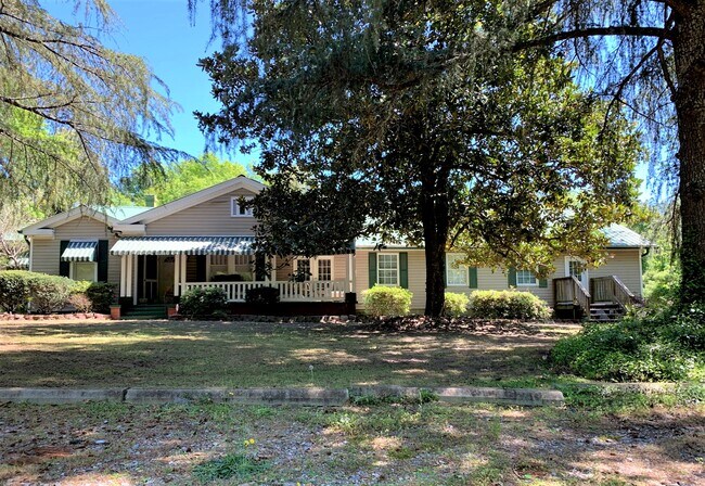
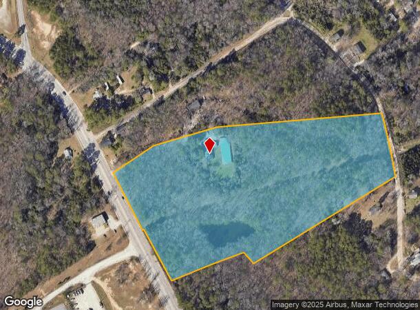
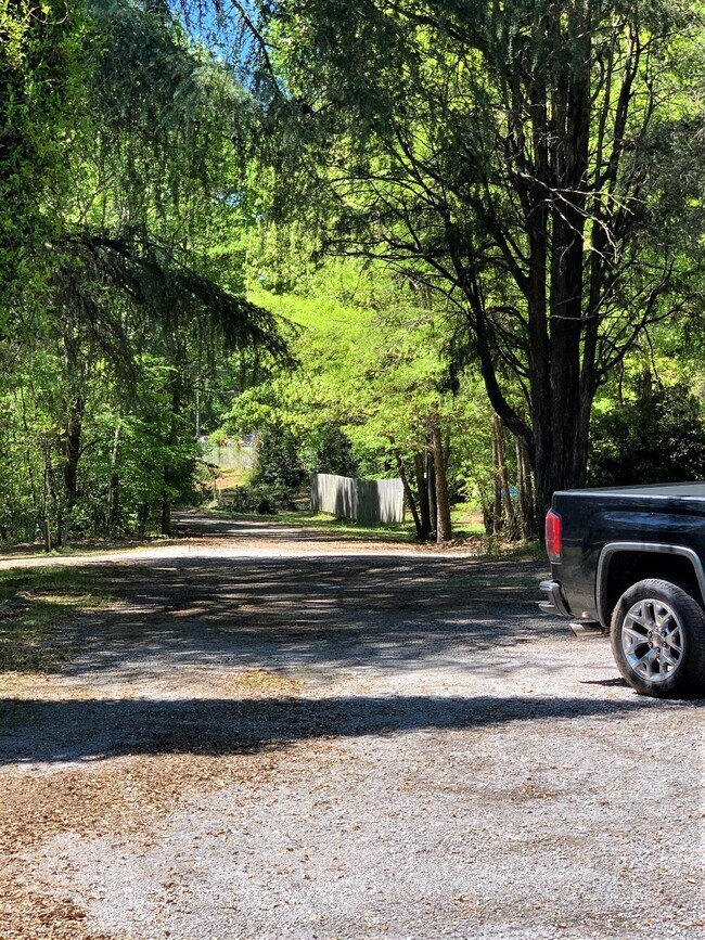
Property Record
7118 Monticello Rd, Columbia, SC 29203
NEARBY LISTINGS FOR SALE OR LEASE
-
-
View all Columbia listings for sale on LoopNet.com
Property Detail
7118 Monticello Rd
09404-02-03
Blue Ridge Terrace
Commercialnec
PARCEL PT B 360.6X225X307.8X773.6X41.8X 291.3X784.9X72.4X346.8X219X8 #PR 432-1294 575-2307
X
Richland
45079C0229L
South Carolina
2025
13.11 AC
2024
North Columbia
010701
Columbia
3,555 SF
Columbia, SC
DEMOGRAPHICS near 7118 Monticello Rd
1 Mile
3 Mile
5 Mile
2024 Total Population
1,594
25,714
90,425
2029 Population
1,627
26,104
92,766
Pop Growth 2024-2029
+ 2.07%
+ 1.52%
+ 2.59%
Average Age
38
39
39
2024 Total Households
640
9,421
39,213
HH Growth 2024-2029
+ 2.03%
+ 1.88%
+ 2.73%
Median Household Inc
$40,922
$38,292
$40,732
Avg Household Size
2.40
2.20
2.10
2024 Avg HH Vehicles
2.00
2.00
1.00
Median Home Value
$83,098
$102,008
$135,659
Median Year Built
1965
1971
1974
Nearby Places
Map Layers
Map Styles
 Street
 Aerial
- Restaurants
- Banks
- Shops
- Fitness
- Groceries
PUBLIC TRANSPORTATION
COMMUTER RAIL
Columbia Amtrak Station (Silver Star - Amtrak)
DRIVE
WALK
Distance
Columbia Amtrak Station (Silver Star - Amtrak)
16 min
7.1 mi
AIRPORT
Columbia Metro
DRIVE
WALK
Distance
Columbia Metro
29 min
16.4 mi
Freight Ports
North Charleston Terminal
DRIVE
WALK
Distance
North Charleston Terminal
129 min
112.7 mi
SALE & LEASE HISTORY
LISTING DATE
SALE/LEASE

Apr 06, 2020
For Sale
Nearby Properties
Address
Land Use
TOTAL SIZE
Lot Size
Zoning
Address
Land Use
TOTAL SIZE
Lot Size
Zoning
278,912 SF
23.24 AC
RM-HD
Address
Land Use
TOTAL SIZE
Lot Size
Zoning
207,112 SF
16.86 AC
RM-HD
Address
Land Use
TOTAL SIZE
Lot Size
Zoning
208,688 SF
13.02 AC
RM-HD
Address
Land Use
TOTAL SIZE
Lot Size
Zoning
2,268 SF
27.70 AC
RM-1
Address
Land Use
TOTAL SIZE
Lot Size
Zoning
195,550 SF
17.19 AC
GC
Address
Land Use
TOTAL SIZE
Lot Size
Zoning
169,278 SF
12.21 AC
RM-HD
Address
Land Use
TOTAL SIZE
Lot Size
Zoning
153,272 SF
9.63 AC
RM-HD
Address
Land Use
TOTAL SIZE
Lot Size
Zoning
127,063 SF
14.70 AC
RM-HD
Address
Land Use
TOTAL SIZE
Lot Size
Zoning
178,000 SF
11.71 AC
RM-1
Address
Land Use
TOTAL SIZE
Lot Size
Zoning
124,272 SF
7.06 AC
RM-HD
Address
Land Use
TOTAL SIZE
Lot Size
Zoning
63,842 SF
3.52 AC
C-3
Address
Land Use
TOTAL SIZE
Lot Size
Zoning
4,986 SF
5.74 AC
PUD-C
Address
Land Use
TOTAL SIZE
Lot Size
Zoning
98,436 SF
14 AC
INS-GEN
Address
Land Use
TOTAL SIZE
Lot Size
Zoning
141,468 SF
13.57 AC
RM-HD
Address
Land Use
TOTAL SIZE
Lot Size
Zoning
194,212 SF
15.10 AC
RG-2
Address
Land Use
TOTAL SIZE
Lot Size
Zoning
63,476 SF
3.95 AC
RM-HD
Address
Land Use
TOTAL SIZE
Lot Size
Zoning
31,218 SF
2.89 AC
RS-3
Address
Land Use
TOTAL SIZE
Lot Size
Zoning
190,561 SF
12.58 AC
RM-HD
Address
Land Use
TOTAL SIZE
Lot Size
Zoning
166,095 SF
9.70 AC
RM-2
Address
Land Use
TOTAL SIZE
Lot Size
Zoning
74,478 SF
8.02 AC
GC
Address
Land Use
TOTAL SIZE
Lot Size
Zoning
120,665 SF
9.50 AC
RM-2
Address
Land Use
TOTAL SIZE
Lot Size
Zoning
6.79 AC
RG-2
Address
Land Use
TOTAL SIZE
Lot Size
Zoning
100 SF
375.99 AC
INS-GEN
Address
Land Use
TOTAL SIZE
Lot Size
Zoning
25,408 SF
13.58 AC
C-3
Address
Land Use
TOTAL SIZE
Lot Size
Zoning
100 SF
1,152.66 AC
INS-GEN
Address
Land Use
TOTAL SIZE
Lot Size
Zoning
30,000 SF
3.47 AC
M-1
Address
Land Use
TOTAL SIZE
Lot Size
Zoning
58,315 SF
7.03 AC
M-1
Address
Land Use
TOTAL SIZE
Lot Size
Zoning
16,441 SF
25.36 AC
RS-MD
Address
Land Use
TOTAL SIZE
Lot Size
Zoning
16,760 SF
1.47 AC
RS-LD
Address
Land Use
TOTAL SIZE
Lot Size
Zoning
38,400 SF
3.60 AC
M-1
The World's #1 Commercial Real Estate Marketplace
Connect with us
© 2026 CoStar Group
The information above has been obtained from sources believed reliable. While we do not doubt its accuracy we have not verified it and make no guarantee, warranty or representation about it. It is your responsibility to independently confirm its accuracy and completeness. Any projections, opinions, assumptions, or estimates used are for example only and do not represent the current or future performance of the property. The value of this transaction to you depends on tax and other factors which should be evaluated by your tax, financial, and legal advisors. You and your advisors should conduct a careful, independent investigation of the property to determine to your satisfaction the suitability of the property for your needs.