Property Record
7118 N Highway 81, Duncan, OK 73533
NEARBY LISTINGS FOR SALE OR LEASE
-
-
View all Duncan listings for lease on LoopNet.com
Property Detail
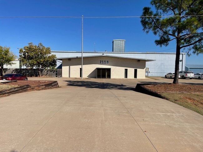
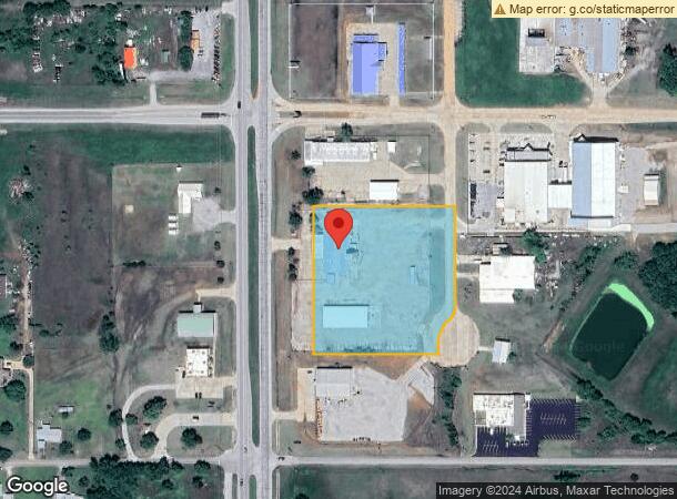
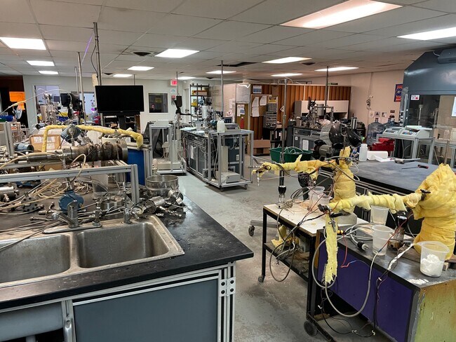
7118 N Highway 81
Duncan, OK
N/A
1999-05-01N-07W-3-004-00
5-1N-7W TR BEG 319N 134.8E OF SW/C SW N001700W431 E415.5 S000300E288.2 TH SWRLY ALG CURVE TO R HAV RADIUS OF 50 A DIST OF 42.
Privateutilityelectricwatergasnuclearsolarwindetc
Stephens
X
Oklahoma
40137C0225F
7w
2024
4 AC
2025
Oklahoma West Area
000800
Other Market Areas
7,800 SF
DEMOGRAPHICS near 7118 N Highway 81
1 Mile
3 Mile
5 Mile
2024 Total Population
99
3,742
18,250
2029 Population
96
3,836
18,835
Pop Growth 2024-2029
(3.03%)
+ 2.51%
+ 3.21%
Average Age
46
45
43
2024 Total Households
41
1,563
7,464
HH Growth 2024-2029
(2.44%)
+ 2.37%
+ 3.05%
Median Household Inc
$68,863
$75,072
$59,471
Avg Household Size
2.40
2.40
2.40
2024 Avg HH Vehicles
2.00
2.00
2.00
Median Home Value
$186,666
$196,659
$160,655
Median Year Built
1985
1982
1975
Nearby Places
- Restaurants
- Banks
- Shops
- Fitness
- Groceries
PUBLIC TRANSPORTATION
AIRPORT
Lawton-Fort Sill Regional
DRIVE
WALK
Distance
Lawton-Fort Sill Regional
39 min
29.1 mi
Freight Ports
Tulsa Port Of Catoosa
DRIVE
WALK
Distance
Tulsa Port Of Catoosa
216 min
198.0 mi
SALE & LEASE HISTORY
LISTING DATE
SALE/LEASE

Sep 20, 2024
For Lease
Oct 28, 2022
For Sale
Nearby Properties
Address
Land Use
TOTAL SIZE
Lot Size
Zoning
Address
Land Use
TOTAL SIZE
Lot Size
Zoning
154 SF
14 AC
Address
Land Use
TOTAL SIZE
Lot Size
Zoning
160 SF
43.16 AC
Address
Land Use
TOTAL SIZE
Lot Size
Zoning
5,037 SF
13.41 AC
Address
Land Use
TOTAL SIZE
Lot Size
Zoning
2,989 SF
13.49 AC
C2
Address
Land Use
TOTAL SIZE
Lot Size
Zoning
10,418 SF
3.39 AC
R1
Address
Land Use
TOTAL SIZE
Lot Size
Zoning
160 SF
6.70 AC
C2
Address
Land Use
TOTAL SIZE
Lot Size
Zoning
532 SF
40.47 AC
C1
Address
Land Use
TOTAL SIZE
Lot Size
Zoning
5,250 SF
4.17 AC
C1
Address
Land Use
TOTAL SIZE
Lot Size
Zoning
6,250 SF
5 AC
C1
Address
Land Use
TOTAL SIZE
Lot Size
Zoning
10,500 SF
1.91 AC
C2
Address
Land Use
TOTAL SIZE
Lot Size
Zoning
930 SF
7.92 AC
C1
Address
Land Use
TOTAL SIZE
Lot Size
Zoning
11,768 SF
1.38 AC
C2
Address
Land Use
TOTAL SIZE
Lot Size
Zoning
7,380 SF
8.61 AC
R1
Address
Land Use
TOTAL SIZE
Lot Size
Zoning
3,708 SF
3.79 AC
R1
Address
Land Use
TOTAL SIZE
Lot Size
Zoning
21,826 SF
5.35 AC
C2
Address
Land Use
TOTAL SIZE
Lot Size
Zoning
1,750 SF
5 AC
R1
Address
Land Use
TOTAL SIZE
Lot Size
Zoning
3,845 SF
2.37 AC
Address
Land Use
TOTAL SIZE
Lot Size
Zoning
28,025 SF
3.86 AC
C2
Address
Land Use
TOTAL SIZE
Lot Size
Zoning
13,800 SF
7.20 AC
C2
Address
Land Use
TOTAL SIZE
Lot Size
Zoning
30,000 SF
4.88 AC
C2
Address
Land Use
TOTAL SIZE
Lot Size
Zoning
1,200 SF
2.82 AC
R1
Address
Land Use
TOTAL SIZE
Lot Size
Zoning
1,782 SF
2.70 AC
R1
Address
Land Use
TOTAL SIZE
Lot Size
Zoning
7,200 SF
14.05 AC
C2
Address
Land Use
TOTAL SIZE
Lot Size
Zoning
138,230 SF
20.48 AC
C1
Address
Land Use
TOTAL SIZE
Lot Size
Zoning
3,848 SF
8.48 AC
C1
Address
Land Use
TOTAL SIZE
Lot Size
Zoning
966 SF
4.81 AC
C2
Address
Land Use
TOTAL SIZE
Lot Size
Zoning
3,985 SF
5 AC
C1
Address
Land Use
TOTAL SIZE
Lot Size
Zoning
1,800 SF
14.65 AC
C2
Address
Land Use
TOTAL SIZE
Lot Size
Zoning
3,600 SF
45.04 AC
The World's #1 Commercial Real Estate Marketplace
Connect with us
© 2025 CoStar Group
The information above has been obtained from sources believed reliable. While we do not doubt its accuracy we have not verified it and make no guarantee, warranty or representation about it. It is your responsibility to independently confirm its accuracy and completeness. Any projections, opinions, assumptions, or estimates used are for example only and do not represent the current or future performance of the property. The value of this transaction to you depends on tax and other factors which should be evaluated by your tax, financial, and legal advisors. You and your advisors should conduct a careful, independent investigation of the property to determine to your satisfaction the suitability of the property for your needs.