Property Record
712 Marshall Rd, Valley Park, MO 63088

Save to a Folder
{{folder.Name}}
{{folder.ListingIds.length}} Properties
{{folder.ListingIds.length}} Property
Create a New Folder
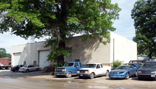
Property Detail
712 Marshall Rd
St. Louis, MO-IL
VALLEY PARK LOTS 3 & 4 4 15 81
26P-53-1143
ST. LOUIS
Warehouse
Missouri
58PDI
3,4
2024
0.30 AC
2025
West County
218104
St. Louis
4,500 SF
NEARBY LISTINGS FOR SALE OR LEASE
DEMOGRAPHICS near 712 Marshall Rd
1 mile
3 mile
5 mile
2025 Total Population
2,304
54,845
147,873
2030 Population
2,271
53,942
146,232
Pop Growth 2025-2030
(1.43%)
(1.65%)
(1.11%)
Average Age
41
42
42
2025 Total Households
1,162
22,662
59,008
HH Growth 2025-2030
(1.81%)
(1.65%)
(1.11%)
Median Household Inc
$67,028
$105,831
$112,030
Avg Household Size
1.90
2.40
2.50
2025 Avg HH Vehicles
1.00
2.00
2.00
Median Home Value
$214,527
$339,063
$359,604
Median Year Built
1987
1981
1978
Nearby Places
Map Layers
Map Styles
 Street
 Aerial
Layers
 Traffic
 Biking
Places
Listings with unknown addresses are not visible on the map
- Restaurants
- Banks
- Shops
- Fitness
- Groceries
PUBLIC TRANSPORTATION
COMMUTER RAIL
Kirkwood Amtrak Station (Lincoln Service Missouri River Runner - Amtrak, Missouri River Runner - Amtrak)
Drive
Walk
Distance
Kirkwood Amtrak Station (Lincoln Service Missouri River Runner - Amtrak, Missouri River Runner - Amtrak)
12 min
5.3 mi
AIRPORT
St Louis Lambert International
Drive
Walk
Distance
St Louis Lambert International
34 min
23.0 mi
Freight Ports
Tulsa Port of Inola
Drive
Walk
Distance
Tulsa Port of Inola
403 min
367.0 mi
Nearby Properties
Address
Land Use
TOTAL SIZE
Lot Size
Zoning
Address
Land Use
TOTAL SIZE
Lot Size
Zoning
429,212 SF
53.13 AC
C-8
Address
Land Use
TOTAL SIZE
Lot Size
Zoning
96.62 AC
R3
Address
Land Use
TOTAL SIZE
Lot Size
Zoning
862,067 SF
40.98 AC
C-8
Address
Land Use
TOTAL SIZE
Lot Size
Zoning
633,127 SF
51.20 AC
NU
Address
Land Use
TOTAL SIZE
Lot Size
Zoning
228,889 SF
43.21 AC
A
Address
Land Use
TOTAL SIZE
Lot Size
Zoning
256,956 SF
23.68 AC
21IP-1
Address
Land Use
TOTAL SIZE
Lot Size
Zoning
62.50 AC
NU
Address
Land Use
TOTAL SIZE
Lot Size
Zoning
534,280 SF
23.37 AC
21IP-1
Address
Land Use
TOTAL SIZE
Lot Size
Zoning
474,239 SF
34.85 AC
R4
Address
Land Use
TOTAL SIZE
Lot Size
Zoning
105.49 AC
Address
Land Use
TOTAL SIZE
Lot Size
Zoning
284,400 SF
10.72 AC
55RSING
Address
Land Use
TOTAL SIZE
Lot Size
Zoning
460,421 SF
34.91 AC
21BP-2
Address
Land Use
TOTAL SIZE
Lot Size
Zoning
194,252 SF
10.66 AC
21IP-1
Address
Land Use
TOTAL SIZE
Lot Size
Zoning
68,441 SF
26.01 AC
58PDC
Address
Land Use
TOTAL SIZE
Lot Size
Zoning
19.25 AC
55INSTU
Address
Land Use
TOTAL SIZE
Lot Size
Zoning
117.18 AC
FPPS
Address
Land Use
TOTAL SIZE
Lot Size
Zoning
112,840 SF
0.54 AC
C-8
Address
Land Use
TOTAL SIZE
Lot Size
Zoning
159,696 SF
10.52 AC
21IP-1
Address
Land Use
TOTAL SIZE
Lot Size
Zoning
157,584 SF
13.60 AC
21IP-1
Address
Land Use
TOTAL SIZE
Lot Size
Zoning
10.41 AC
21IP-1
Address
Land Use
TOTAL SIZE
Lot Size
Zoning
26.56 AC
NU
Address
Land Use
TOTAL SIZE
Lot Size
Zoning
375,522 SF
42.58 AC
C-8
Address
Land Use
TOTAL SIZE
Lot Size
Zoning
148,800 SF
26.31 AC
21IP-1
Address
Land Use
TOTAL SIZE
Lot Size
Zoning
206,018 SF
18.78 AC
R1
Address
Land Use
TOTAL SIZE
Lot Size
Zoning
224,872 SF
34.78 AC
21BP-2
Address
Land Use
TOTAL SIZE
Lot Size
Zoning
8.84 AC
21IP-1
Address
Land Use
TOTAL SIZE
Lot Size
Zoning
246,426 SF
8.87 AC
94R-6
Address
Land Use
TOTAL SIZE
Lot Size
Zoning
182,616 SF
15.86 AC
21IP-1
Address
Land Use
TOTAL SIZE
Lot Size
Zoning
69,910 SF
8.62 AC
M3
Address
Land Use
TOTAL SIZE
Lot Size
Zoning
9.63 AC
21IP-1
The World's #1 Commercial Real Estate Marketplace
Connect with us
© 2026 CoStar Group
The information above has been obtained from sources believed reliable. While we do not doubt its accuracy we have not verified it and make no guarantee, warranty or representation about it. It is your responsibility to independently confirm its accuracy and completeness. Any projections, opinions, assumptions, or estimates used are for example only and do not represent the current or future performance of the property. The value of this transaction to you depends on tax and other factors which should be evaluated by your tax, financial, and legal advisors. You and your advisors should conduct a careful, independent investigation of the property to determine to your satisfaction the suitability of the property for your needs.