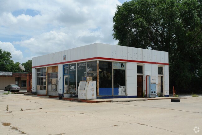
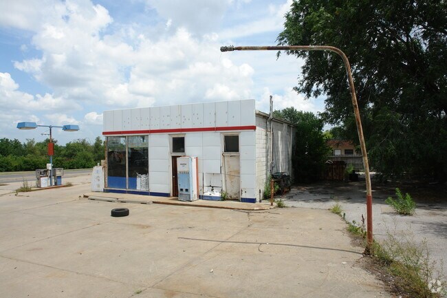
Property Record
7121 Harrison St, La Vista, NE 68128

NEARBY LISTINGS FOR SALE OR LEASE
Property Detail
7121 Harrison St
Omaha-Council Bluffs, NE-IA
La Vista Replat
010331794
LOT 1C EX PT TO RD LA VISTA REPLAT
Commercialnec
Sarpy
X
Nebraska
31153C0060G
1c
2024
0.36 AC
2025
Sarpy East
010615
Omaha/Council Bluffs
DEMOGRAPHICS near 7121 Harrison St
1 Mile
3 Mile
5 Mile
2024 Total Population
9,138
87,299
219,569
2029 Population
9,651
90,881
227,709
Pop Growth 2024-2029
+ 5.61%
+ 4.10%
+ 3.71%
Average Age
39
39
38
2024 Total Households
3,728
35,215
85,844
HH Growth 2024-2029
+ 5.55%
+ 4.02%
+ 3.73%
Median Household Inc
$65,926
$66,090
$69,933
Avg Household Size
2.40
2.40
2.50
2024 Avg HH Vehicles
2.00
2.00
2.00
Median Home Value
$175,977
$209,361
$218,359
Median Year Built
1975
1977
1973
Nearby Places
Map Layers
Map Styles
 Street
 Aerial
- Restaurants
- Banks
- Shops
- Fitness
- Groceries
PUBLIC TRANSPORTATION
COMMUTER RAIL
Omaha Amtrak Station (California Zephyr - Amtrak)
DRIVE
WALK
Distance
Omaha Amtrak Station (California Zephyr - Amtrak)
14 min
8.7 mi
Omaha Amtrak Station (California Zephyr - Amtrak)
DRIVE
WALK
Distance
Omaha Amtrak Station (California Zephyr - Amtrak)
15 min
8.9 mi
AIRPORT
Eppley Airfield
DRIVE
WALK
Distance
Eppley Airfield
23 min
12.7 mi
Freight Ports
Tulsa Port Of Catoosa
DRIVE
WALK
Distance
Tulsa Port Of Catoosa
464 min
417.7 mi
Nearby Properties
Address
Land Use
TOTAL SIZE
Lot Size
Zoning
Address
Land Use
TOTAL SIZE
Lot Size
Zoning
25,204 SF
2.34 AC
R4
Address
Land Use
TOTAL SIZE
Lot Size
Zoning
341,667 SF
24.15 AC
Address
Land Use
TOTAL SIZE
Lot Size
Zoning
503,886 SF
25.40 AC
Address
Land Use
TOTAL SIZE
Lot Size
Zoning
317,277 SF
20.12 AC
Address
Land Use
TOTAL SIZE
Lot Size
Zoning
28,913 SF
2.04 AC
Address
Land Use
TOTAL SIZE
Lot Size
Zoning
897,738 SF
52.16 AC
Address
Land Use
TOTAL SIZE
Lot Size
Zoning
354,299 SF
22.85 AC
R6
Address
Land Use
TOTAL SIZE
Lot Size
Zoning
294,672 SF
15.06 AC
Address
Land Use
TOTAL SIZE
Lot Size
Zoning
646,213 SF
37.22 AC
Address
Land Use
TOTAL SIZE
Lot Size
Zoning
354,615 SF
18.13 AC
R6
Address
Land Use
TOTAL SIZE
Lot Size
Zoning
13,930 SF
1.04 AC
Address
Land Use
TOTAL SIZE
Lot Size
Zoning
199,152 SF
13.44 AC
R6
Address
Land Use
TOTAL SIZE
Lot Size
Zoning
271,344 SF
9.78 AC
Address
Land Use
TOTAL SIZE
Lot Size
Zoning
271,404 SF
17.51 AC
Address
Land Use
TOTAL SIZE
Lot Size
Zoning
309,162 SF
15.54 AC
Address
Land Use
TOTAL SIZE
Lot Size
Zoning
97,617 SF
49.05 AC
Address
Land Use
TOTAL SIZE
Lot Size
Zoning
2,610 SF
9.96 AC
Address
Land Use
TOTAL SIZE
Lot Size
Zoning
286,445 SF
16.18 AC
R6
Address
Land Use
TOTAL SIZE
Lot Size
Zoning
407,410 SF
4.03 AC
Address
Land Use
TOTAL SIZE
Lot Size
Zoning
237,171 SF
10.27 AC
R6
Address
Land Use
TOTAL SIZE
Lot Size
Zoning
225,009 SF
12.03 AC
Address
Land Use
TOTAL SIZE
Lot Size
Zoning
14,019 SF
10.92 AC
Address
Land Use
TOTAL SIZE
Lot Size
Zoning
199,586 SF
2.93 AC
Address
Land Use
TOTAL SIZE
Lot Size
Zoning
108,554 SF
4.85 AC
Address
Land Use
TOTAL SIZE
Lot Size
Zoning
217,511 SF
25.06 AC
Address
Land Use
TOTAL SIZE
Lot Size
Zoning
149,713 SF
10.46 AC
Address
Land Use
TOTAL SIZE
Lot Size
Zoning
172,272 SF
7.48 AC
R6
Address
Land Use
TOTAL SIZE
Lot Size
Zoning
6,472 SF
4.58 AC
Address
Land Use
TOTAL SIZE
Lot Size
Zoning
170,665 SF
10.94 AC
Address
Land Use
TOTAL SIZE
Lot Size
Zoning
148,688 SF
10.85 AC
The World's #1 Commercial Real Estate Marketplace
Connect with us
© 2025 CoStar Group
The information above has been obtained from sources believed reliable. While we do not doubt its accuracy we have not verified it and make no guarantee, warranty or representation about it. It is your responsibility to independently confirm its accuracy and completeness. Any projections, opinions, assumptions, or estimates used are for example only and do not represent the current or future performance of the property. The value of this transaction to you depends on tax and other factors which should be evaluated by your tax, financial, and legal advisors. You and your advisors should conduct a careful, independent investigation of the property to determine to your satisfaction the suitability of the property for your needs.