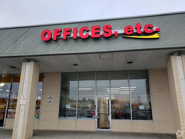
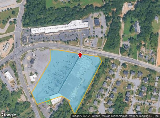
Property Record
7050 Allentown Rd, Temple Hills, MD 20748
Current Lease Availabilities
NEARBY LISTINGS FOR SALE OR LEASE
Property Detail
7050 Allentown Rd
09-0934240
PARCEL E
Regionalshoppingcenterormallwithanchorstore
Prince George's
X
Maryland
24033C0245E
7.98 AC
2024
Branch Avenue Corridor
2025
Washington, DC
801212
Washington-Arlington-Alexandria, DC-VA-MD-WV
71,178 SF
DEMOGRAPHICS near 7050 Allentown Rd
1 Mile
3 Mile
5 Mile
2024 Total Population
9,502
69,327
235,242
2029 Population
9,195
67,468
226,996
Pop Growth 2024-2029
(3.23%)
(2.68%)
(3.51%)
Average Age
44
41
40
2024 Total Households
3,222
26,357
91,393
HH Growth 2024-2029
(3.32%)
(2.74%)
(3.72%)
Median Household Inc
$112,015
$92,703
$75,367
Avg Household Size
2.90
2.60
2.50
2024 Avg HH Vehicles
2.00
2.00
2.00
Median Home Value
$363,159
$351,941
$345,397
Median Year Built
1967
1975
1972
Nearby Places
- Restaurants
- Banks
- Shops
- Fitness
- Groceries
PUBLIC TRANSPORTATION
AIRPORT
Ronald Reagan Washington Ntl
DRIVE
WALK
Distance
Ronald Reagan Washington Ntl
28 min
14.9 mi
Baltimore/Washington International Thurgood Marshall
DRIVE
WALK
Distance
Baltimore/Washington International Thurgood Marshall
54 min
36.1 mi
Freight Ports
Port of Baltimore
DRIVE
WALK
Distance
Port of Baltimore
64 min
42.7 mi
Nearby Properties
Address
Land Use
TOTAL SIZE
Lot Size
Zoning
Address
Land Use
TOTAL SIZE
Lot Size
Zoning
963,250 SF
10.71 AC
RTOLE
Address
Land Use
TOTAL SIZE
Lot Size
Zoning
417 SF
7.66 AC
RTOLE
Address
Land Use
TOTAL SIZE
Lot Size
Zoning
450 SF
20.72 AC
RMF20
Address
Land Use
TOTAL SIZE
Lot Size
Zoning
6 AC
RTOLE
Address
Land Use
TOTAL SIZE
Lot Size
Zoning
353,064 SF
53.19 AC
CGO
Address
Land Use
TOTAL SIZE
Lot Size
Zoning
111.87 AC
IE
Address
Land Use
TOTAL SIZE
Lot Size
Zoning
98.14 AC
IE
Address
Land Use
TOTAL SIZE
Lot Size
Zoning
29.24 AC
RMF20
Address
Land Use
TOTAL SIZE
Lot Size
Zoning
73.26 AC
IE
Address
Land Use
TOTAL SIZE
Lot Size
Zoning
701 SF
29.42 AC
RMF20
Address
Land Use
TOTAL SIZE
Lot Size
Zoning
450 SF
21.14 AC
RMF20
Address
Land Use
TOTAL SIZE
Lot Size
Zoning
336,465 SF
1.38 AC
CSC
Address
Land Use
TOTAL SIZE
Lot Size
Zoning
21.48 AC
RMF20
Address
Land Use
TOTAL SIZE
Lot Size
Zoning
223,219 SF
22 AC
CGO
Address
Land Use
TOTAL SIZE
Lot Size
Zoning
74.38 AC
IE
Address
Land Use
TOTAL SIZE
Lot Size
Zoning
300,005 SF
9.94 AC
RR
Address
Land Use
TOTAL SIZE
Lot Size
Zoning
7.65 AC
RMF20
Address
Land Use
TOTAL SIZE
Lot Size
Zoning
111.72 AC
IE
Address
Land Use
TOTAL SIZE
Lot Size
Zoning
36,272 SF
3.94 AC
RTOLE
Address
Land Use
TOTAL SIZE
Lot Size
Zoning
324 SF
8.52 AC
RMF48
Address
Land Use
TOTAL SIZE
Lot Size
Zoning
11.65 AC
RMF20
Address
Land Use
TOTAL SIZE
Lot Size
Zoning
138.27 AC
IE
Address
Land Use
TOTAL SIZE
Lot Size
Zoning
434,910 SF
0.46 AC
RR
Address
Land Use
TOTAL SIZE
Lot Size
Zoning
297 SF
13.58 AC
RMF20
Address
Land Use
TOTAL SIZE
Lot Size
Zoning
115,888 SF
12.36 AC
CGO
Address
Land Use
TOTAL SIZE
Lot Size
Zoning
160,870 SF
3.75 AC
RMF48
Address
Land Use
TOTAL SIZE
Lot Size
Zoning
174,894 SF
7.54 AC
CGO
Address
Land Use
TOTAL SIZE
Lot Size
Zoning
67.32 AC
IE
Address
Land Use
TOTAL SIZE
Lot Size
Zoning
8.43 AC
RTOLE
Address
Land Use
TOTAL SIZE
Lot Size
Zoning
169.75 AC
IE
The World's #1 Commercial Real Estate Marketplace
Connect with us
© 2025 CoStar Group
The information above has been obtained from sources believed reliable. While we do not doubt its accuracy we have not verified it and make no guarantee, warranty or representation about it. It is your responsibility to independently confirm its accuracy and completeness. Any projections, opinions, assumptions, or estimates used are for example only and do not represent the current or future performance of the property. The value of this transaction to you depends on tax and other factors which should be evaluated by your tax, financial, and legal advisors. You and your advisors should conduct a careful, independent investigation of the property to determine to your satisfaction the suitability of the property for your needs.